Home > Blog > Weather Today
Weather Today – February 10, 2015 | Typhoon Higos poses no threat in the PH
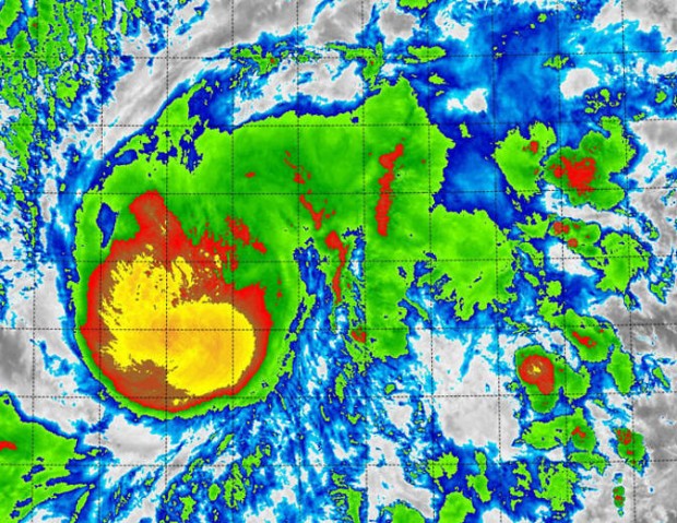
The tropical cyclone with international name “Higos: is now in typhoon category. Packing winds of 120 kph and gustiness of up to 150 kph, it slowly moves in a northwest direction.
State Meteorologist Manny Mendoza assures the public that Higos has a very slim chance of entering the Philippine Area of Responsibility.

Today, the northeast monsoon continues to prevail over Luzon, bringing cloudy skies and light rains over the regions of Cagayan Valley, Ilocos and Bicol as well as the provinces of Aurora and Quezon.
The rest of Luzon, including Metro Manila, will have isolated light rains. Visayas and Mindanao, on the other hand, will experience partly cloudy to cloudy skies with isolated rain showers or thunderstorms in the following hours.
Meanwhile, strong to gale force winds associated with the surge of the northeast monsoon brings rough to very rough sea conditions over the seaboards of Northern Luzon and the eastern seaboards of Central and Southern Luzon. Fishermen are advised against sea travel in these coasts today.
WEATHER 101
Temperature and relative humidity are always included in PAGASA’s weather forecast. How does it affect our daily living?
Let’s start by defining these terms. Temperature is the degree of how hot or cold the atmosphere. Meanwhile, relative humidity is the amount of atmospheric moisture or water vapor the air can hold at a particular temperature.
Mendoza explains if we have higher temperature and lower relative humidity, it means we are having warm and humid weather. This is usually associated with the easterlies or the winds coming from the Pacific Ocean. On the other hand, if we have lower temperatures and higher relative humidity, it results to cold and dry air –also experienced same as during the northeast monsoon season.
Latest Advisories
