Home > Blog > Weather Today
Weather Today – April 3, 2015 | Chedeng weakens, 7 areas in Luzon under Signal#1

Despite the cyclone’s weakening, PAGASA reminds the public to brace itself for the possible effects of Typhoon Chedeng this weekend.
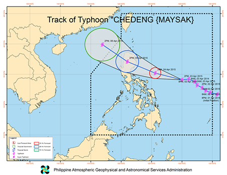
At 4 PM today, the eye of the typhoon was estimated at 845 kms. east-southeast of Casiguran, Aurora. Packing winds of 140 kph near the center and gustiness of up to 170 kph, Chedeng maintains its typhoon category. However, PAGASA claims it has a higher chance of further weakening as it moves closer to the archipelago. State Meteorologist Aldczar Aurelio says there is a possibility that Chedeng may be downgraded to tropical storm category before hitting the landmass.
One such factor of the typhoon’s weakening is the strong vertical wind shear or the wind strength along the cyclone. Aurelio likened it to a humming top or ‘trumpo’ where winds differ in the bottom and top areas of the cyclone. Chedeng may also weaken due to land interaction, especially in mountainous areas that may help break the cyclone’s wind formation.
In the latest run of the various weather forecasting models of the weather bureau, here’s what we can expect:
April 5 – Sunday
Morning: Chedeng to make landfall over the Aurora-Isabela area.
Evening: Chedeng to leave the landmass via Ilocos Sur.
April 6 – Monday
Morning: Chedeng to exit the Philippine Area of Responsibility.
Based on PAGASA’s latest weather bulletin, Public Storm Warning Signal number 1 is raised over Isabela, Aurora, Quezon including Polillo Island, Catanduanes, Camarines Norte and Camarines Sur.
These areas may still be experiencing good weather conditions now, but the effects of Chedeng may be felt in at least 36 hours, or in a day and a half.
PAGASA also mentions the possibility of hoisting the same warning signal over Cagayan, Nueva Ecija, Nueva Vizcaya and the Cordillera Administrative Region in the next 12 hours as Chedeng moves closer to Eastern Luzon.

In a press briefing held in PAGASA this afternoon, Aurelio explains that although the country is experiencing good weather today, rains with occasional gusty winds can be expected by late Saturday, escalating to stormy weather, particularly over the Central-Northern Luzon area come Sunday.
In the Greater Metro Manila Area, there is a poor chance of having a storm warning signal raised. However, expect occasional rains and gusty winds as Chedeng crosses the land. The remaining parts of the country, on the other hand, can expect warm and humid weather, Aurelio added.
As Chedeng threatens the country, officials remind the residents living in areas under signal #1 to be prepared against possible flash floods and landslides. Storm surges of up to 2 metes are also possible over the eastern coast of Aurora, Quezon and Isabela. Even fisherfolk over the eastern seaboard of Bicol Region and Visayas are advised against sea travel due to the rough to very rough sea conditions generated by Chedeng.
Latest Advisories
