Home > Blog > Weather Today
Weather Today – May 11, 2015 | #DODONGPH hits Sta. Ana, Cagayan
Lashing with heavy winds and moderate to intense rains, Dodong’s eye passed over Pananapan Point in Sta. Ana, Cagayan 4:45 this afternoon.
The typhoon made landfall, bearing maximum sustained winds of 185 kph near the center and gustiness of up to 220 kph. Once it made contact with the land, it slowed down a bit, moving north northwest at 17 kph.
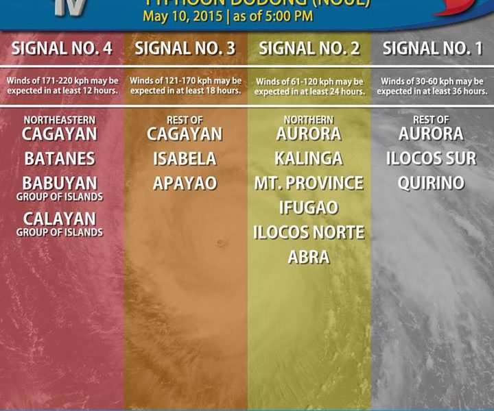
Based on PAGASA’s latest weather bulletin issued at 5 o’clock in the afternoon, here are the areas under public storm warning signals:

In a press briefing held late afternoon in PAGASA, State Meteorologist Aldczar Aurelio said that after Cagayan, Dodong will head towards the Batanes area in the following hours.
If it maintains its current speed and direction, the typhoon is expected to exit the Philippine Area of Responsibility by Tuesday morning and will continue to move towards Southern Japan.

As for the expected weather conditions in the country tonight, the areas under signal #4 will continue to experience a stormy weather due to the typhoon. The provinces under signal #3 can expect rains with gusty winds. On the other hand, areas under signal #1 and #2 will have light to moderate rain showers. The rest of the country can expect partly cloudy to cloudy skies with localized thunderstorms.
Meanwhile, PAGASA releases a new gale warning over the eastern seaboards of Southern Luzon. These coastal areas will experience strong to gale force winds and rough to very rough sea conditions generated by Typhoon Dodong. All fishermen are advised against sea travel in the following hours.

In other news, the Mines and Geosciences Bureau (MGB) released an advisory today pertaining to the highly susceptible barangays in Sta. Ana, Baggao and Gonzaga in Cagayan.
Here is the list:


Latest Advisories
