Are you enjoying the cold weather? The early days of February brought in chilly temperatures, thanks to the northeast monsoon or amihan, characterized by cold and dry air coming from Siberia or Mainland China. According to PAGASA, the amihan season will last until the third week of the month. But aside from the cool relief the weather brings, it also comes with risks.
Sipon or Common Colds. Research shows that the cold virus survives and reproduces more effectively during this season, making it easier for it to spread and infect people. To reduce the risk of getting a cold, observe proper hygiene, such as washing your hands often with soap and water. Avoid touching your eyes, nose, and mouth with unwashed hands, and stay away from people who are sick.
Trangkaso or Flu. To avoid flu, short for influenza, avoid close contact with people who are sick, cover your mouth and nose when coughing or sneezing, and disinfect frequently-touched surfaces at home.
Asthma. Cold weather triggers asthma attacks because cold and dry air irritates the airways, causing their muscles to spasm. To prevent this, outdoor exercise should be limited.
Sore throat. Cold air usually dries out throat tissues, causing severe irritation. To avoid sore throat, frequently wash hands and sanitize frequently-touched things. Always cover both neck and head when going outside.
Dry skin. During this season, our skin’s moisture easily evaporates, making skin tight, flaky, and dry. To lessen the dryness, use moisturizers and gentle soap, and avoid bathing in hot water.
Whatever the weather is, make sure to observe proper hygiene, and take precautionary measures to lessen your exposure to viruses that may trigger these illnesses.
In the meantime, enjoy the sweater weather while it lasts!
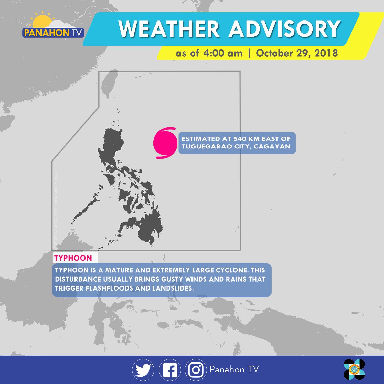
As of 5:00 a.m., Typhoon Rosita was spotted 540 kilometers (km) east of Tuguegarao City, Cagayan. It has maximum sustained winds of 170 kilometers per hour (kph) and gustiness of up to 210 kph. The Typhoon has slightly weakened as it moves westward at 15 kph. It will bring stormy weather or heavy rains with strong winds in Cagayan, Isabela, Quirino, Aurora and Polilio Island. Meanwhile, rains with gusty winds are expected in the Cordillera Administrative Region, Ilocos Region, the rest of Cagayan Valley and Central Luzon, and the provinces of Rizal and Camarines Norte. Due to its trough or extension, Metro Manila, the rest of CALABARZON and of Bicol Region will have cloudy skies with scattered rain showers and thunderstorms. Meanwhile, partly cloudy to cloudy skies with isolated rain showers will prevail in the rest of the country.
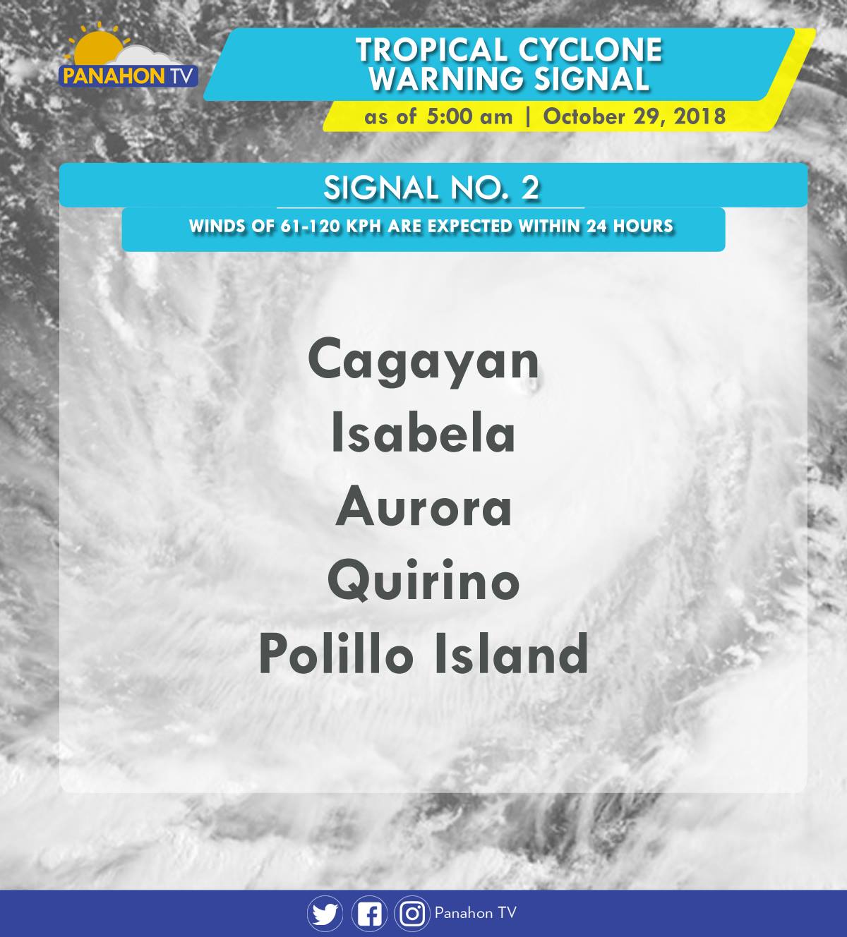
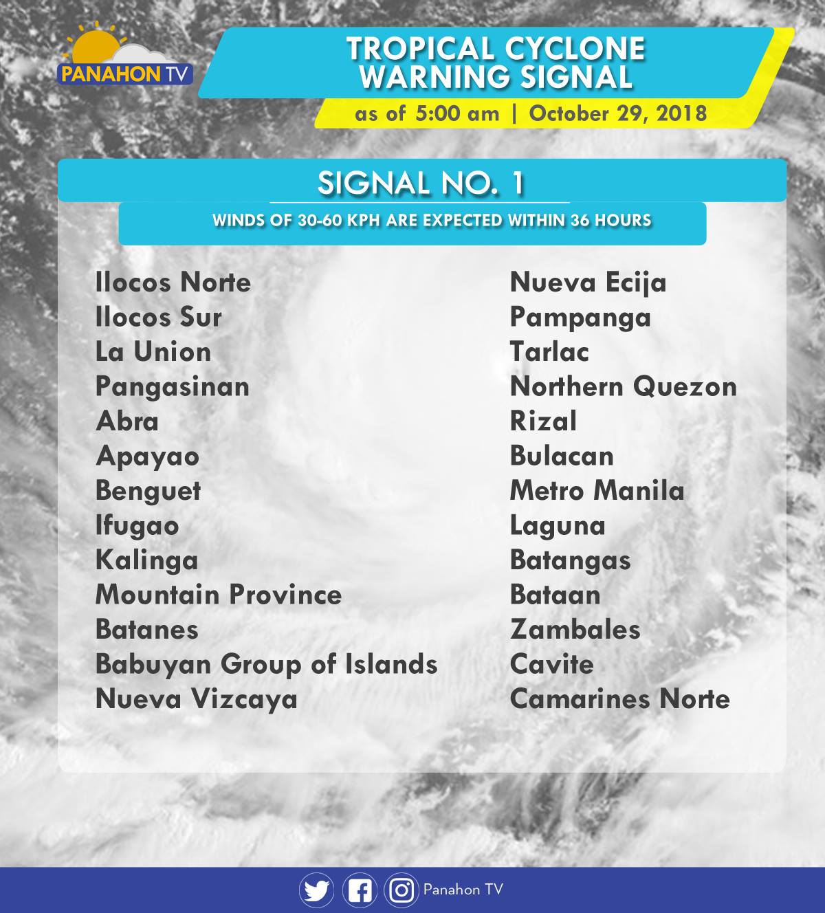
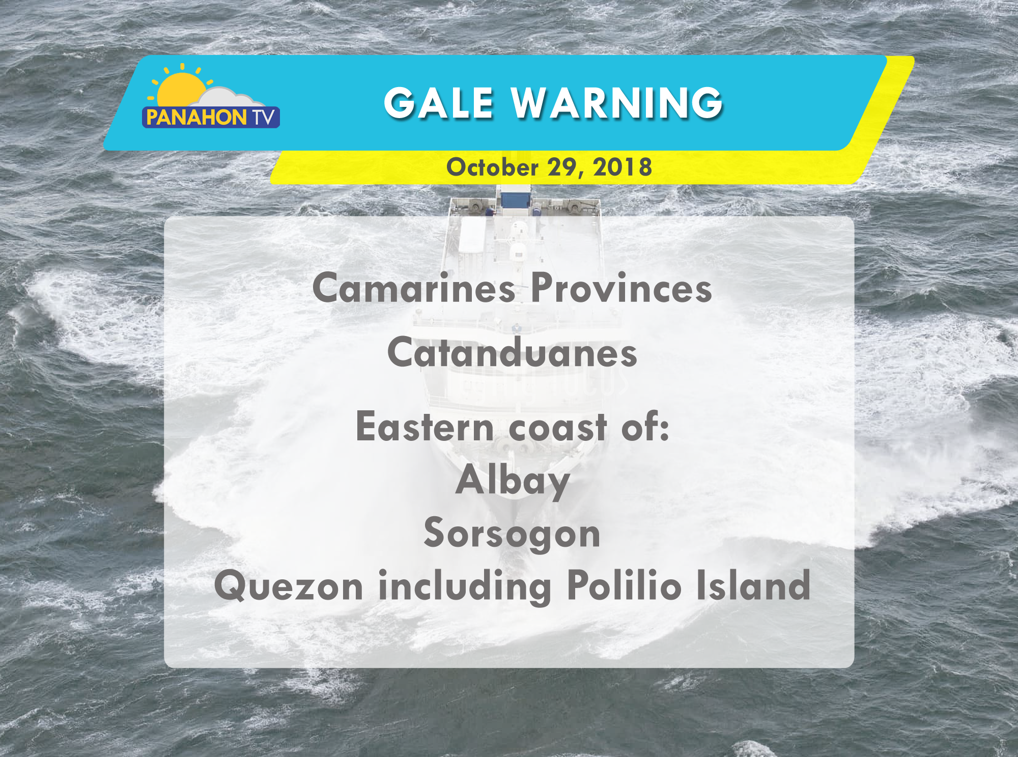
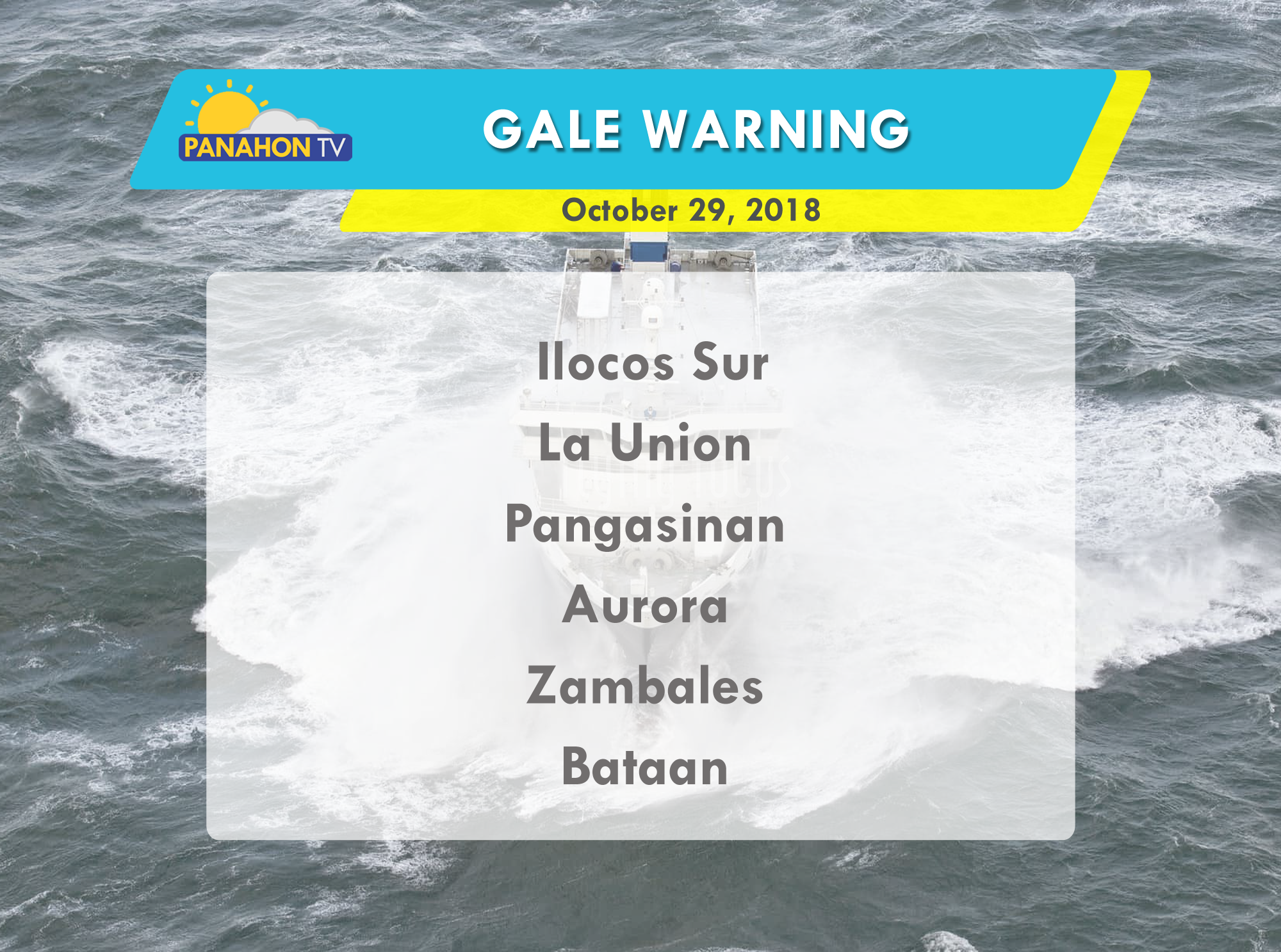
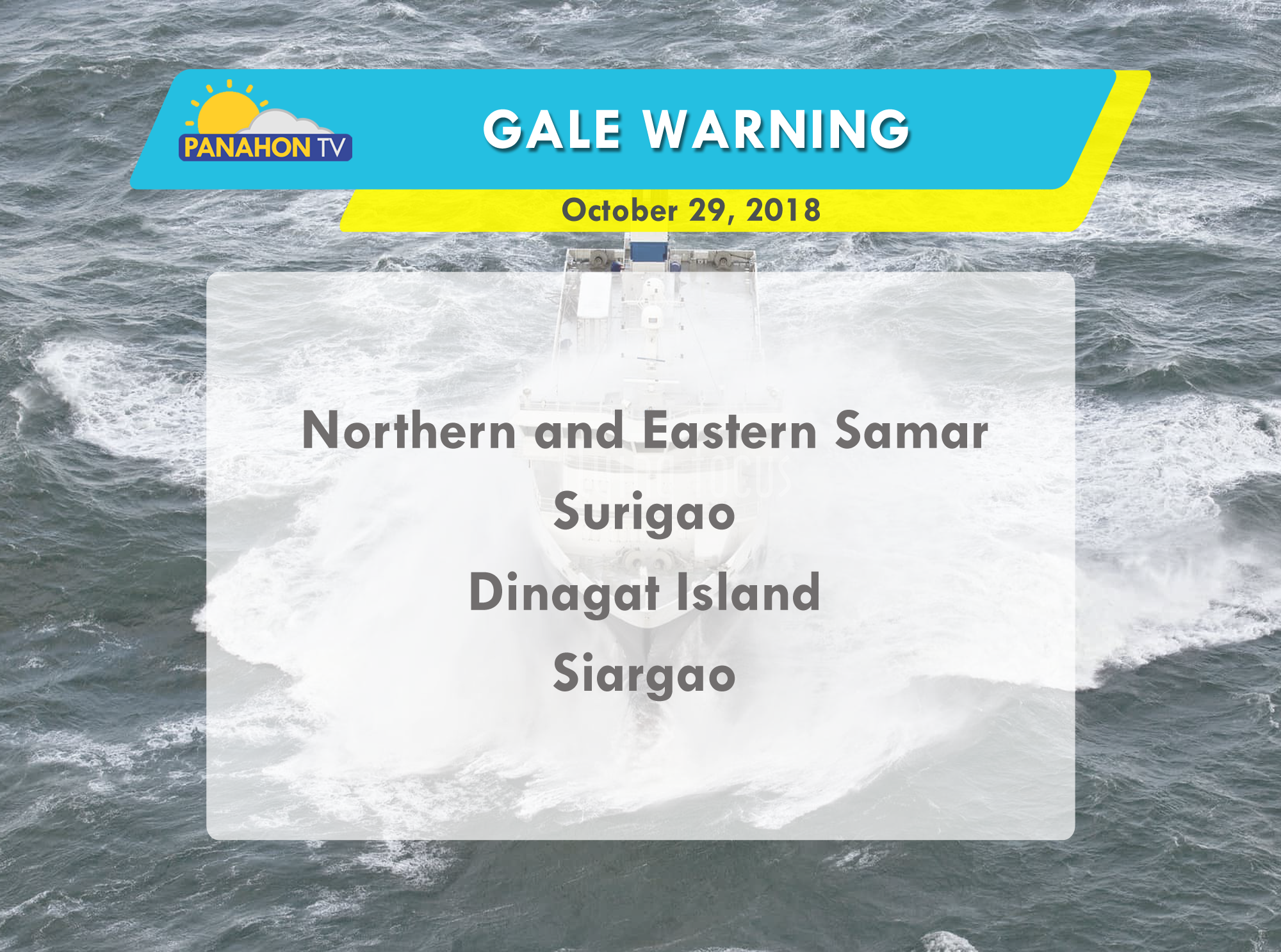
As Typhoon Rosita approaches the eastern section of Northern Luzon, Tropical Cyclone Warning Signals (TCWS) are raised by PAGASA in the following areas in preparation for incoming Typhoon.
In an Interview with PAGASA Weather Forecaster Ezra Bulquerin, he mentioned that the Typhoon may slightly weaken as it traverses the landmass of Northern Luzon. Although some parts of the country are already experiencing stormy weather, the Typhoon is expected to hit the landmass of Isabela-Cagayan later this evening. He also added that the Northeast Monsoon will not strengthen the Typhoon, but will only steer it toward Northern Luzon.
Due to strong waves brought by the Typhoon, gale warning is issued in the following areas:

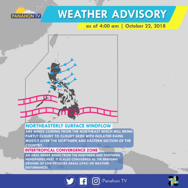
The Northeasterly Surface Windflow continues to affect Luzon, bringing cloudy skies with scattered rain showers and thunderstorms in Quezon, Bicol Region and the rest of MIMAROPA. Meanwhile, cloudy skies with scattered rain showers and thunderstorms are expected in Mindanao and Palawan caused by the Intertropical Convergence Zone (ITCZ), or the imaginary where winds from Northern and Southern Hemisphere meet. Metro Manila and the rest of the country will have partly cloudy to cloudy skies with isolated rain showers.
According to PAGASA Weather Forecaster Meno Mendoza, a Tropical Storm with international name “Yutu” was spotted outside the Philippine Area of Responsibility (PAR) 3,375 km east of Mindanao. It is expected to move northward, and will not enter PAR. He also added that cold air brought by the Amihan or Northeast Monsoon will be felt in the last week of October.
No gale warning is issued today.
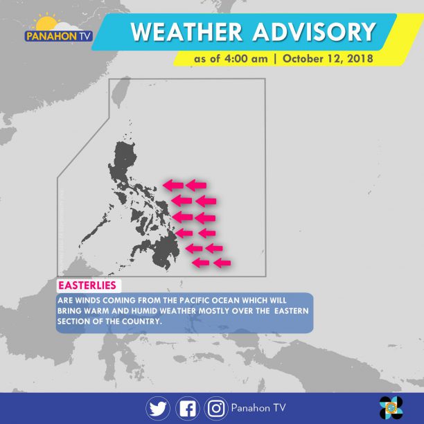
As of 4:00 a.m., Easterlies or winds coming from the Pacific Ocean, affect the eastern section of Southern Luzon, Visayas, and Mindanao. It will bring hot and humid air that may cause localized thunderstorms by afternoon or evening. Meanwhile, Metro Manila and the rest of the country will experience partly cloudy to cloudy skies with isolated rain showers
According to PAGASA Weather Forecaster Gener Quitlong, although the Amihan (Northeast Monsoon) is affecting the coastal tip of Northern Luzon, Easterlies remains the dominant weather system. Quitlong says we can expect storm-free weather in the next 2 -3 days.
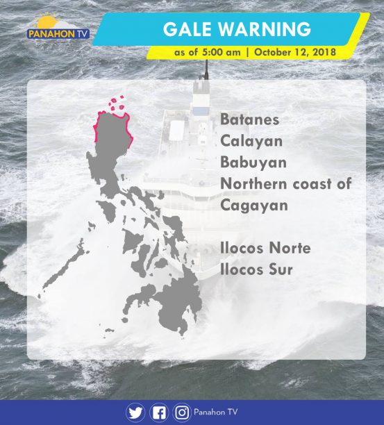
Due to the winds from the Northeast Monsoon, gale warning was issued in the following areas.
The Northeast Monsoon or Amihan has weakened, leaving Easterlies, the warm and humid aid from the Pacific as the dominant weather system.
With the presence of Easterlies, Caraga and Davao Region will have cloudy skies with scattered rain showers and thunderstorms. Meanwhile, the rest of the country including Metro Manila, can expect a generally fair weather only with chances of isolated rain showers.
Gale warning has also been lifted.

The Amihan or Northeast Monsoon, cold and dry air from Siberia, dominates the Extreme Northern Luzon.
In the next hours, Batanes, Cagayan, Apayao, and Ilocos Norte will experience cloudy skies with scattered rains. The remaining parts of Cagayan Valley, Cordillera, and Ilocos Region will have partly cloudy to cloudy skies with isolated rains. In the rest of Luzon, including Metro Manila, down to Visayas and Mindanao, partly cloudy to cloudy skies, or generally fair weather will prevail only with isolated rain showers.
With the continued presence of the Amihan, temperatures dropped at 15.5 degrees Celsius in Tanay, Rizal on Thursday, while Baguio City and Itbayat, Batanes recorded 16.0 and 18.5 degrees Celsius, accordingly.
Gale warning is still in effect in the northern seaboards of Northern Luzon. These include coasts of Batanes, Babuyan Group of Islands, and the northern coasts of Cagayan and of Ilocos Norte. Fishing boats and other small seacraft are prohibited from venturing, while larger sea vessels are alerted against rough to very rough seas.
Two weather systems will continue to bring lights rains to Northern and Central Luzon today.
According to PAGASA, the Northeast Monsoon or Amihan has intensified, bringing cloudy skies with light rains in Cordillera, Batanes, Babuyan, Cagayan and Isabela. In Eastern and Central Visayas, Bicol Region, Aurora and Quezon, cloudy skies with scattered rain showers and isolated thunderstorms will be experienced due to the Tail-End of a Cold Front. In Metro Manila, Ilocos Region and the rest of Central Luzon and Cagayan Valley, partly cloudy to cloudy skies will be experienced with light rains. In the remaining parts of the country, generally fair weather will be experienced only with isolated rain showers or thunderstorms.
Because of the surge of Amihan, gale warning is still in effect in the seaboards of Northern Luzon where wave height may reach up to 3.4 to 4.5 meters. Fishing boats and other small seacraft are advised not to venture out into the sea, while larger sea vessels are alerted against big waves in Batanes, Babuyan Group of Islands, Cagayan, the northern and western coasts of Ilocos Norte, the northern coast of Isabela, Ilocos Sur, La Union, Pangasinan, Aurora, and the eastern coast of Quezon including Polilio Island.
In an interview with PAGASA Weather Forecaster Mendoza, he said that the country is expected to remain storm-free in the next two to three days.
Some areas in Northern and Central Luzon will continue to experience lights rains today.
According to PAGASA, the Northeast Monsoon or Amihan prevails in Northern Luzon, bringing cloudy skies with light rains in Cordillera, Batanes, Babuyan, Cagayan and Ilocos Norte. In Isabela, Aurora and Quezon, cloudy skies with scattered rain showers and isolated thunderstorms will be experienced due to the Tail-End of a Cold Front. In the rest of the country, including Metro Manila, partly cloudy to cloudy skies will be experienced but localized thunderstorms are still possible.
Because of the surge of Amihan, gale warning is still in effect off the seaboards of Northern Luzon where wave height may reach up to 3.4 to 4.5 meters. Fishing boats and other small seacraft are advised not to venture out into the sea, while larger sea vessels are alerted against big waves in Batanes, the Babuyan Group of Islands, Ilocos Norte, Ilocos Sur, the northern and eastern coasts of Cagayan, Isabela.
Supermoon brightened the sky
Last night, a larger and brighter moon graced the skies to the delight of selenophiles or moon lovers.
This astronomical event happens when the moon, at a full phase, coincides with the perigee or its closest distance to the Earth. Yesterday, the moon reached its perigee at 4:43 PM and its full phase at 11:47 PM. PAGASA said that the moon appeared 14% larger and 30% brighter than usual.
LOOK | Tonight's Supermoon as seen in Tanza, Cavite. The Moon reached its Perigee (its closest distance to the Earth) at 4:43 PM earlier. At 11:47 PM, it will reach a Full Moon phase and can appear up to 14% larger and 30% brighter than usual.Photos and video captured by Mary Crystalline T. Araracap
Posted by Panahon.TV on Sunday, December 3, 2017
After a short break last week, the Northeast Monsoon is back and has further intensified.
Today, the Northeast Monsoon or Amihan brings cool breezes and rains in Northern and Central Luzon. Meanwhile, the Intertropical Convergence Zone (ITCZ) and Easterlies dampen Mindanao, and the eastern sections Southern Luzon and Visayas, respectively.
Today, Quezon, the Bicol Region, Eastern Visayas and Mindanao will have cloudy skies with scattered rain showers and thunderstorms. In Metro Manila, Ilocos Region, Cordillera, Cagayan Valley, and Central Luzon, partly cloudy to cloudy skies will be experienced with isolated light rains. In the rest of the country, partly cloudy to cloudy skies with isolated rain showers will prevail.
Gale warning is still raised in the northern seaboards of Northern Luzon. These include Batanes, Calayan, Babuyan, and the northern coasts of Cagayan and Ilocos Norte. Due to rough to very rough seas, fishing boats and other small seacraft are advised not to venture out while larger vessels are alerted against big waves.
Cooler Days Ahead
Temperatures continue to dip as the Northeast Monsoon, the cold and dry air from Siberia, intensifies. Yesterday, a chilling 16.6 degrees Celsius was recorded in Baguio City. In Tanay, Rizal 17 degrees Celsius was recorded, while the temperature dropped to 21 degrees Celsius in Infanta, Quezon. The surge of Amihan is expected in January and February.