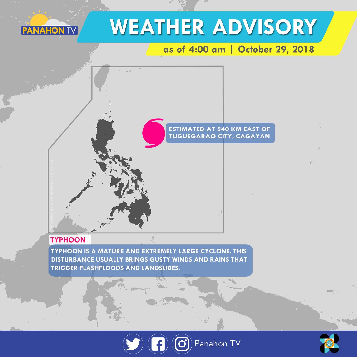
As of 5:00 a.m., Typhoon Rosita was spotted 540 kilometers (km) east of Tuguegarao City, Cagayan. It has maximum sustained winds of 170 kilometers per hour (kph) and gustiness of up to 210 kph. The Typhoon has slightly weakened as it moves westward at 15 kph. It will bring stormy weather or heavy rains with strong winds in Cagayan, Isabela, Quirino, Aurora and Polilio Island. Meanwhile, rains with gusty winds are expected in the Cordillera Administrative Region, Ilocos Region, the rest of Cagayan Valley and Central Luzon, and the provinces of Rizal and Camarines Norte. Due to its trough or extension, Metro Manila, the rest of CALABARZON and of Bicol Region will have cloudy skies with scattered rain showers and thunderstorms. Meanwhile, partly cloudy to cloudy skies with isolated rain showers will prevail in the rest of the country.
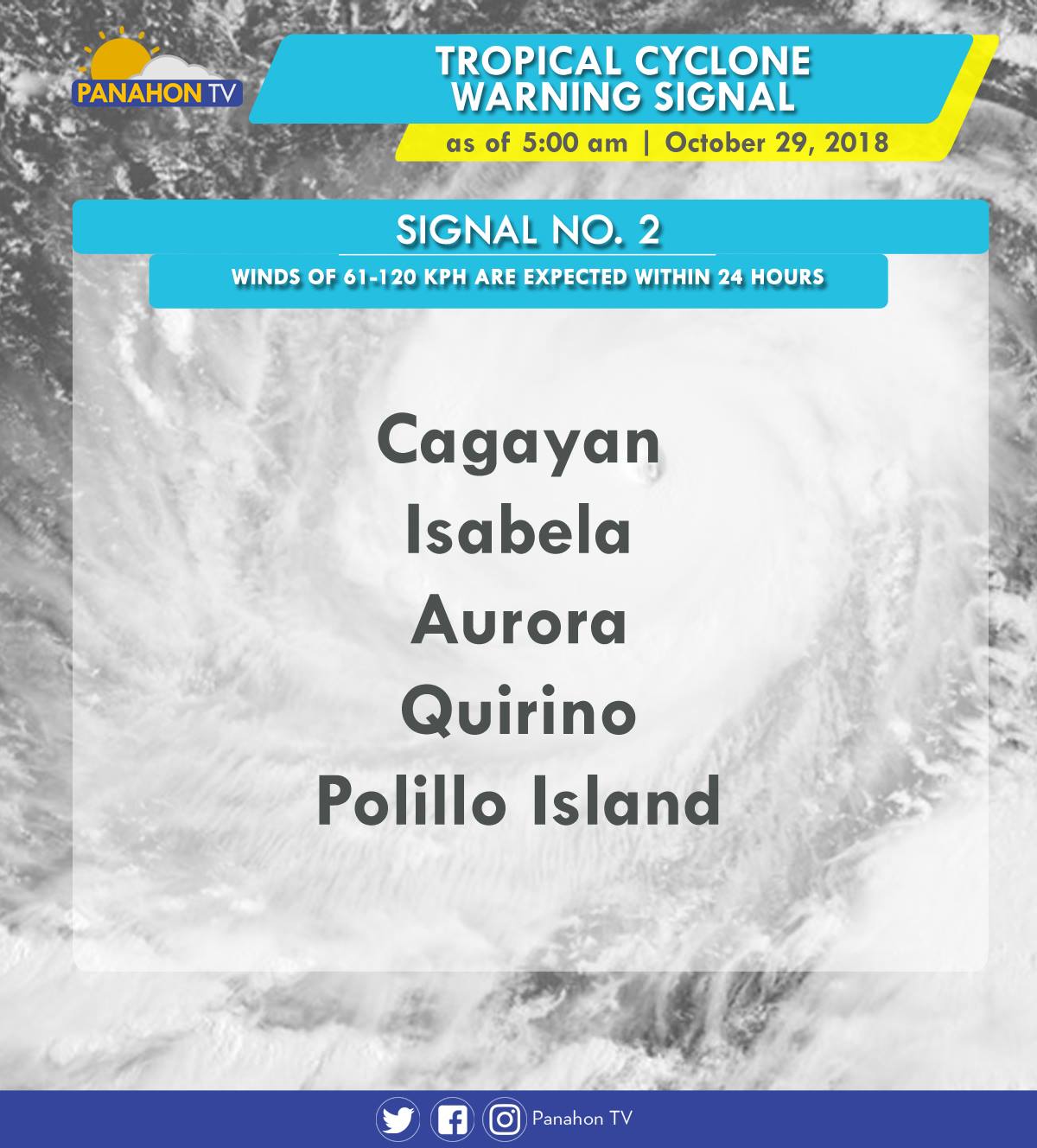
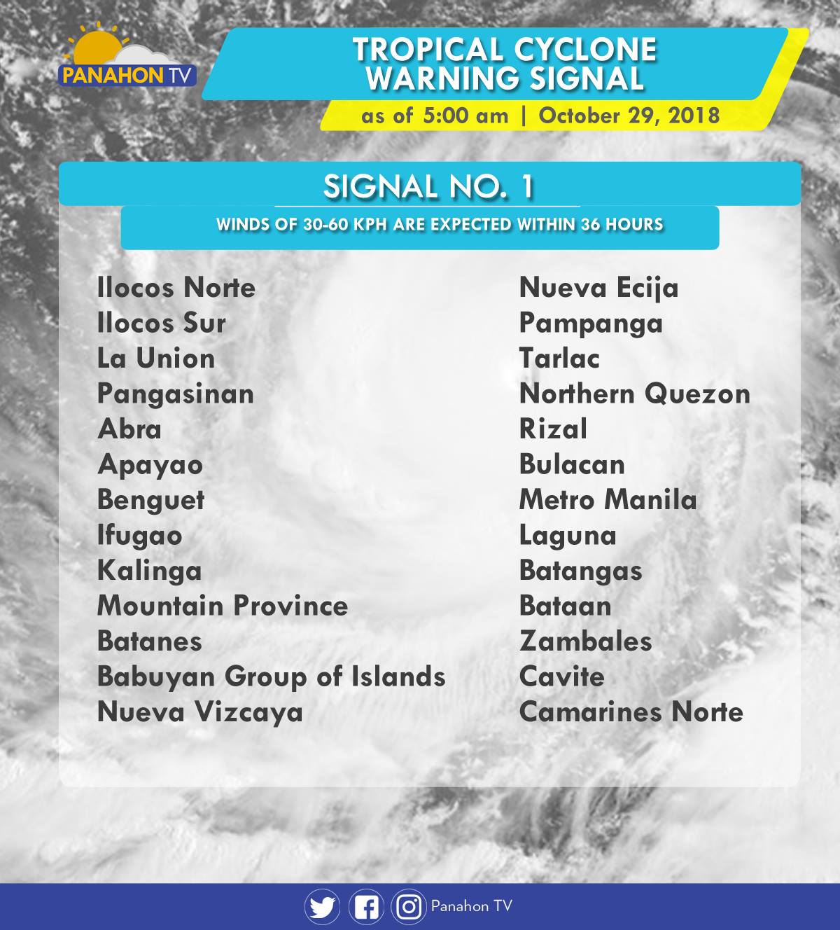
As Typhoon Rosita approaches the eastern section of Northern Luzon, Tropical Cyclone Warning Signals (TCWS) are raised by PAGASA in the following areas in preparation for incoming Typhoon.
In an Interview with PAGASA Weather Forecaster Ezra Bulquerin, he mentioned that the Typhoon may slightly weaken as it traverses the landmass of Northern Luzon. Although some parts of the country are already experiencing stormy weather, the Typhoon is expected to hit the landmass of Isabela-Cagayan later this evening. He also added that the Northeast Monsoon will not strengthen the Typhoon, but will only steer it toward Northern Luzon.
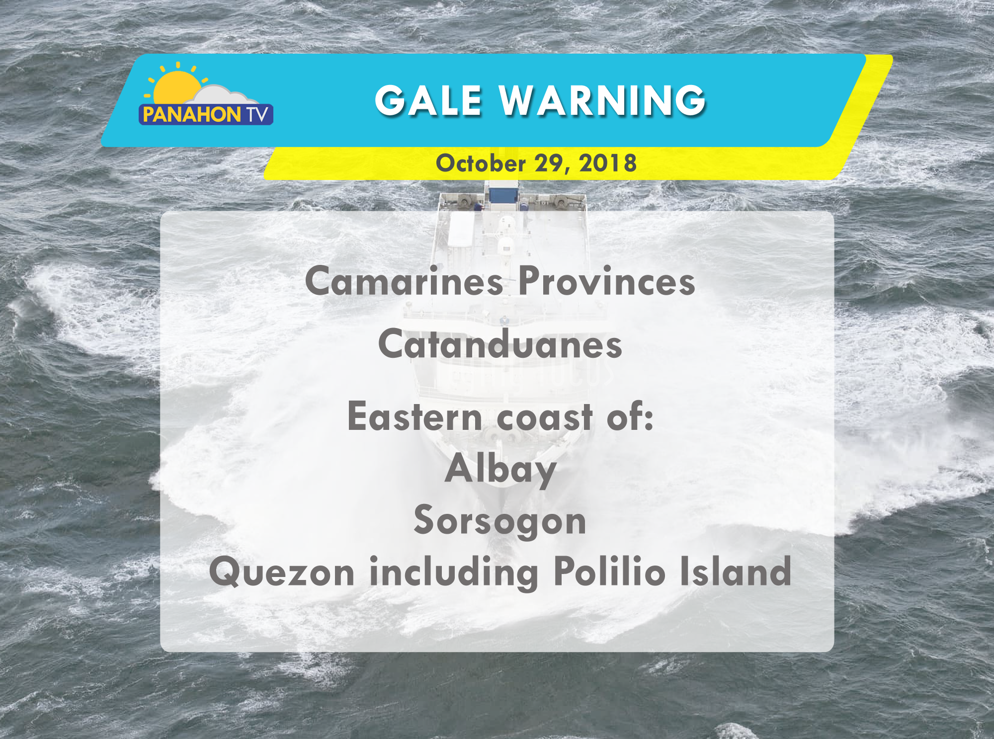
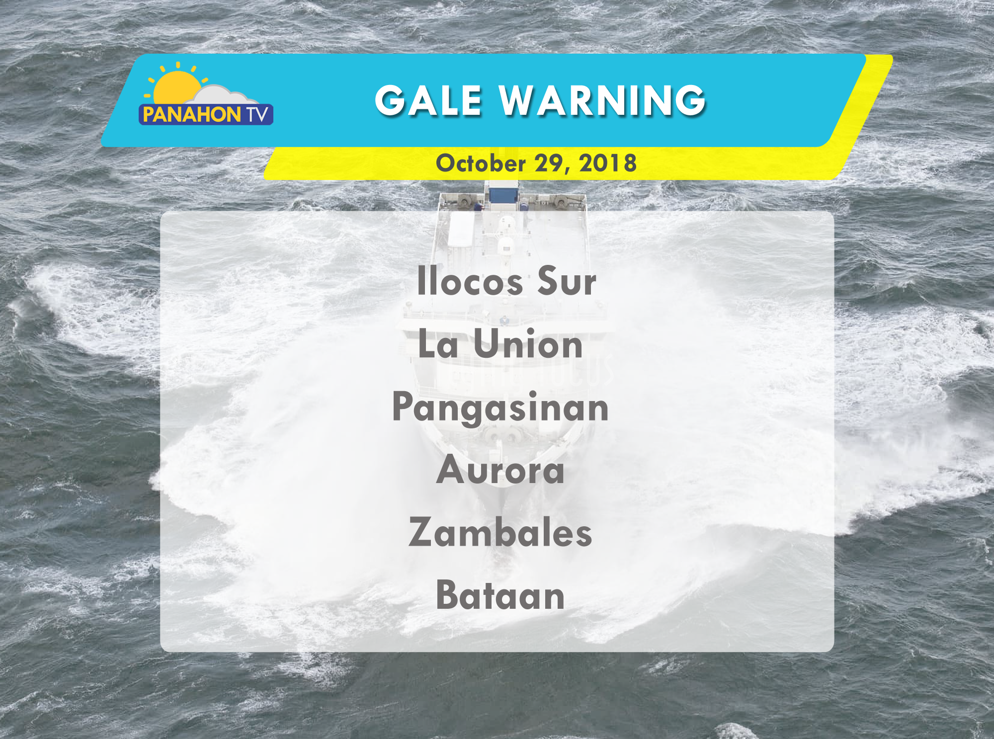
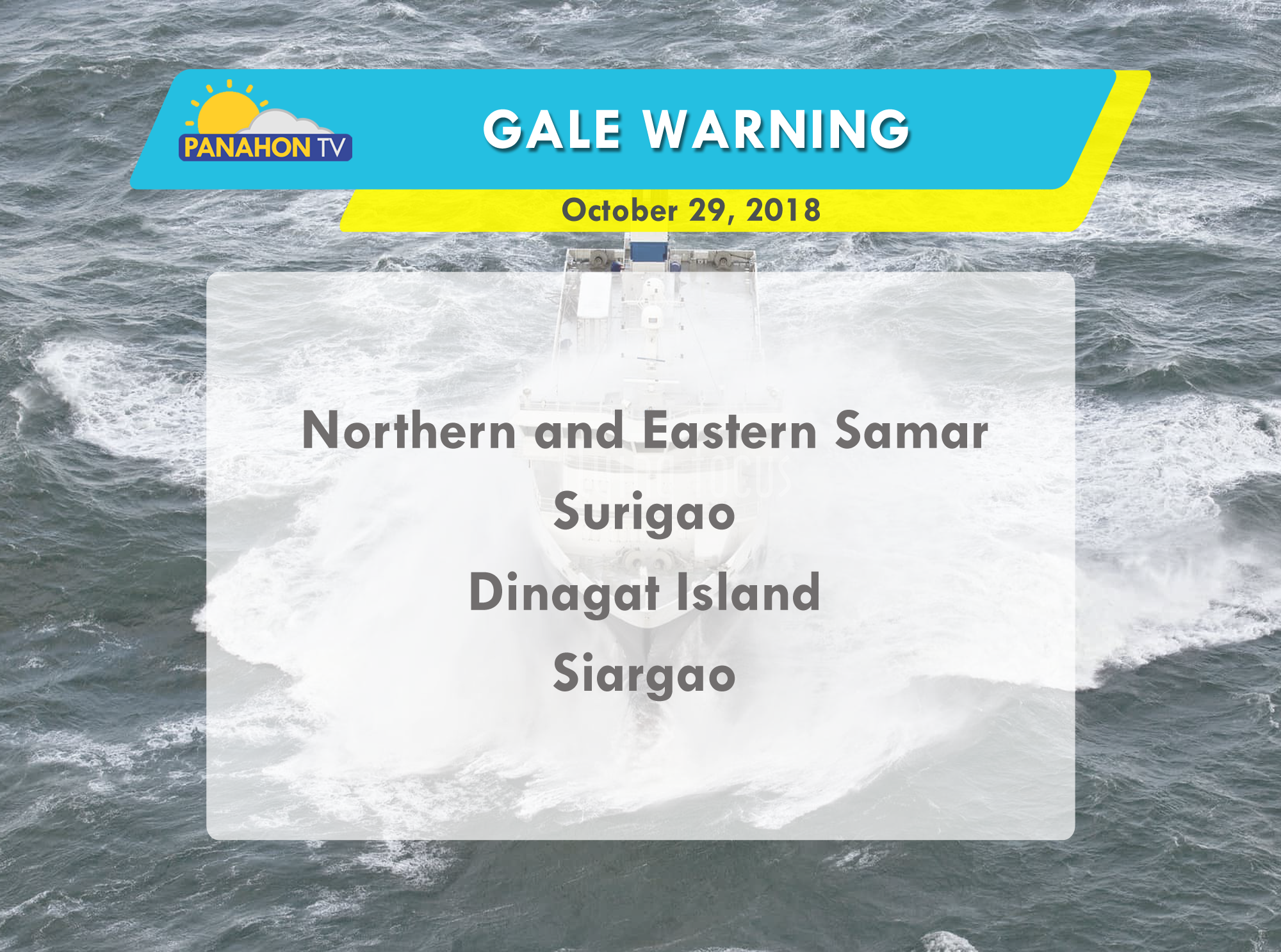
Due to strong waves brought by the Typhoon, gale warning is issued in the following areas:


Rains are more likely to prevail due to the Low Pressure Area (LPA), last located in the vicinity of Maddela, Quirino. PAGASA Weather Forecaster Gener Quitlong noted that it has a slim chance of developing into a Tropical Depression within the day but once it reaches the West Philippine Sea, it may accumulate moisture and may still intensify as a “bagyo”.
Because the LPA is now traversing in between Northern and Central Luzon, it will continue to dump rains in several areas. Cloudy skies with moderate to occasionally heavy rains and thunderstorms are expected in Bicol Region and in the provinces of Cagayan, Apayao, Ilocos Norte, Batanes and the Babuyan Group of Islands. PAGASA alerts the residents against possible flooding and landslides.
Metro Manila and the rest of Luzon will experience cloudy skies with light to moderate rains with thunderstorms. Meanwhile, Visayas and Mindanao can expect partly cloudy to cloudy skies with isolated rain showers or thunderstorms mostly in the afternoon or evening.
Gale warning is up in the northern seaboard of Northern Luzon, where rough to very rough sea condition is expected. Sea travel is risky for fishing boats and other small seacraft as wave height may reach up to 3.4 to 4.5 meters.
Have you noticed the slightly cooler weather mostly in the early morning? Quitlong added that northeasterly winds are already approaching. The ongoing transition period or shifting of wind patterns signifies that Habagat is no longer expected to affect the country. Hence, Amihan season is just around the corner!

Did you savor the cold days of February? We hope you did, because humid days are just around the corner.
The Hot and Dry season is in the country the equivalent of summer. The warm weather is brought by the Easterlies and the Ridge of a High Pressure Area. Easterlies are winds coming from the Pacific Ocean, the largest of the oceanic divisions in the world. On the other hand, a ridge or the extended part of a High Paessure Area (HPA) is associated with good weather. Unlike a Low Pressure Area (LPA), fewer clouds are formed with less chance of precipitation in a HPA.
In an interview with PAGASA Weather Forecaster Meno Mendoza, he said that the termination of Amihan usually marks the beginning of “tag-init.”

“Simula noong 2012 hanggang 2016, ay naganap ang pagtatapos ng Amihan sa pagitan ng pangalawa at pangatlong linggo ng Marso. Kaya’t inaasahan natin na posibleng kaparehas na panahon maganap ang pagpasok ng tag-init.” (Since 2012 until 2016, Amihan had ended between the second and third week of March. We expect the Hot and Dry season to begin within the same period.)
WEATHER TODAY
Today, Northern and Central Luzon remains affected by the Northeast Monsoon, while Easterlies are dominant in the eastern sections of Southern Luzon, Visayas and Mindanao.
Cloudy skies with light rains are expected in Cagayan Valley. Partly cloudy to cloudy skies with isolated rain showers or thunderstorms are expected in Bicol Region, Visayas and Mindanao. Partly cloudy to cloudy skies with isolated light rains prevail in Metro Manila and the rest of Luzon.

There’s no gale warning today but seafarers and those who have small fishing boats are still advised to take precautionary measures against moderate to rough sea conditions.

The Northeast Monsoon or Amihan is now back, affecting the Extreme Northern Luzon. Isolated light rains will be experienced in Batanes, and the Calayan and Babuyan Group of Islands. Meanwhile, Easterlies continuously affect the eastern section of Luzon, Visayas and Mindanao. Fair weather condition is expected in the rest of the archipelago, including Metro Manila, but there are still chances of localized thunderstorms in the afternoon or in the evening.

And because of the surge of the Amihan, gale warning was raised in the northern seaboards of Northern Luzon. It will be bringing wave height up to 3.4 to 4.5 meters, enough to overturn fishing boats and other small seacraft.

As the Northeast Monsoon or Amihan prevails, affecting Northern and Central Luzon, light rains will be experienced in the regions of Cagayan, Ilocos, Cordillera and Central Luzon. Meanwhile, the Tail-End of a Cold Front will bring light to moderate rains over Bicol and Eastern Visayas, and the provinces of Quezon, Romblon and Marinduque. In the rest of our country, including Metro Manila, generally fair weather condition with a chance of localized thunderstorms is expected.
According to PAGASA, this week, including the weekend, is so far, weather disturbance-free. Updates on this will be given regularly.

Meanwhile, because of the surge of the Amihan, gale warning was raised in the eastern seaboards of Central and Southern Luzon. It will be bringing rough to very rough sea conditions with wave height up to 3.4 to 4.5 meters, enough to overturn fishing boats and other small seacraft.

With the two dominant weather systems,the Northeast monsoon (Amihan) and the Tail-end of a cold front, light to moderate rains prevail in Bicol and the provinces of Aurora, Quezon and Samar. Light rains will also be experienced in the regions of Cagayan Valley, Ilocos, Cordillera, and the rest of Central Luzon. In the next hours, fair weather is expected in the rest of the country, including Metro Manila.

Due to the winds associated with the Amihan, gale warning was raised in the seaboards of Northern Luzon, and eastern seaboards of Central and Southern Luzon, and Visayas. Fisherfolk with small seacraft should avoid venturing into the said seaboards due to the rough to very rough sea conditions.
According to PAGASA Weather Forecaster Aldczar Aurelio, the Hot and Dry Season usually begins in March and ends in May, but since the Amihan is still present in our country, this season will be put on hold for a bit. However, Aurelio added that the Amihan will slightly weaken this weekend.

As the Northeast Monsoon (Amihan) strengthens, it brings cold weather to most part of the archipelago, particularly Luzon and Visayas. For those who are residing in the Bicol region, Visayas and the provinces of Mindoro, Marinduque and Romblon, you will be experiencing cloudy skies with light to moderate rains. Meanwhile, light rains prevail in the regions of Cagayan Valley, Cordillera and the provinces of Aurora, Rizal and Quezon. If you are in Metro Manila and the rest of Luzon, isolated light rainsares expected. Favorable weather will prevail over Mindanao, but always bring your umbrella for the possibility of localized thunderstorms.

Gale warning was raised in the seaboards of Luzon and Visayas. Fisherfolk with small seacraft are not allowed to venture into the said seaboards due to the rough to very rough sea conditions. This is due to the strong to gale force winds associated with the Amihan.

As temperature continuously drops, here are the lowest temperature recorded yesterday in Baguio City:

As the Northeast Monsoon (Amihan) intensifies, it affects the extreme Northern Luzon, bringing light rains over Batanes, Calayan and the Babuyan Group of Islands. Meanwhile, the weather system affecting the eastern section of Northern Luzon is the Tail-End of a Cold Front. Light to moderate rains prevail over the rest of Cagayan province and Isabela. For those who are in Metro Manila and the rest of the country, good weather condition will be experienced.

And because the Amihan has slightly strengthened, PAGASA raised gale warning in the northern seaboards of Northern Luzon. For all the fisherfolk and for those with small seacraft, venturing into the said seaboards is not advisable due to the rough to very rough sea conditions.
Because most of us are still busy sweating out the holiday calories at the gym, here are some tips to prevent having rough gym hands.

1. Always use lotion before and after you sleep. This can help protect your dry hands from calluses.
2. Soften your hands by soaking it in warm salty water for 15-30 minutes.
3. Wear gym gloves to prevent calluses.

Even though the Amihan had weakened, gale warning was raised in the northern and eastern seaboards of Northern Luzon, with rough to very rough sea conditions in the seaboards of Batanes, Calayan, Babuyan, the northern coasts of Cagayan, and Ilocos Norte, Isabela and the eastern coast of Cagayan. Small seacraft and fishing boats in these areas are not advised to venture out into the seas.

Meanwhile, light to moderate rains and isolated thunderstorms expected to prevail in the Bicol region and Eastern Visayas, due to the effect of the Tail-End of a Cold Front. Amihan will still be bringing cold weather and light rains over Cagayan Valley Region, while good weather with isolated light rains is expected over Metro Manila and the rest of Luzon. Generally fair weather is expected in Visayas and Mindanao, but there’s a possibility of localized thunderstorms especially in the afternoon or in the evening.