Are you enjoying the cold weather? The early days of February brought in chilly temperatures, thanks to the northeast monsoon or amihan, characterized by cold and dry air coming from Siberia or Mainland China. According to PAGASA, the amihan season will last until the third week of the month. But aside from the cool relief the weather brings, it also comes with risks.
Sipon or Common Colds. Research shows that the cold virus survives and reproduces more effectively during this season, making it easier for it to spread and infect people. To reduce the risk of getting a cold, observe proper hygiene, such as washing your hands often with soap and water. Avoid touching your eyes, nose, and mouth with unwashed hands, and stay away from people who are sick.
Trangkaso or Flu. To avoid flu, short for influenza, avoid close contact with people who are sick, cover your mouth and nose when coughing or sneezing, and disinfect frequently-touched surfaces at home.
Asthma. Cold weather triggers asthma attacks because cold and dry air irritates the airways, causing their muscles to spasm. To prevent this, outdoor exercise should be limited.
Sore throat. Cold air usually dries out throat tissues, causing severe irritation. To avoid sore throat, frequently wash hands and sanitize frequently-touched things. Always cover both neck and head when going outside.
Dry skin. During this season, our skin’s moisture easily evaporates, making skin tight, flaky, and dry. To lessen the dryness, use moisturizers and gentle soap, and avoid bathing in hot water.
Whatever the weather is, make sure to observe proper hygiene, and take precautionary measures to lessen your exposure to viruses that may trigger these illnesses.
In the meantime, enjoy the sweater weather while it lasts!
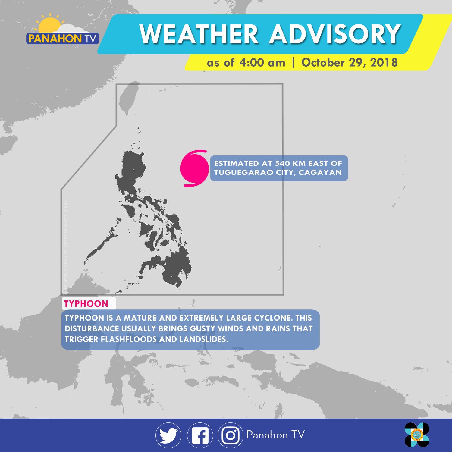
As of 5:00 a.m., Typhoon Rosita was spotted 540 kilometers (km) east of Tuguegarao City, Cagayan. It has maximum sustained winds of 170 kilometers per hour (kph) and gustiness of up to 210 kph. The Typhoon has slightly weakened as it moves westward at 15 kph. It will bring stormy weather or heavy rains with strong winds in Cagayan, Isabela, Quirino, Aurora and Polilio Island. Meanwhile, rains with gusty winds are expected in the Cordillera Administrative Region, Ilocos Region, the rest of Cagayan Valley and Central Luzon, and the provinces of Rizal and Camarines Norte. Due to its trough or extension, Metro Manila, the rest of CALABARZON and of Bicol Region will have cloudy skies with scattered rain showers and thunderstorms. Meanwhile, partly cloudy to cloudy skies with isolated rain showers will prevail in the rest of the country.
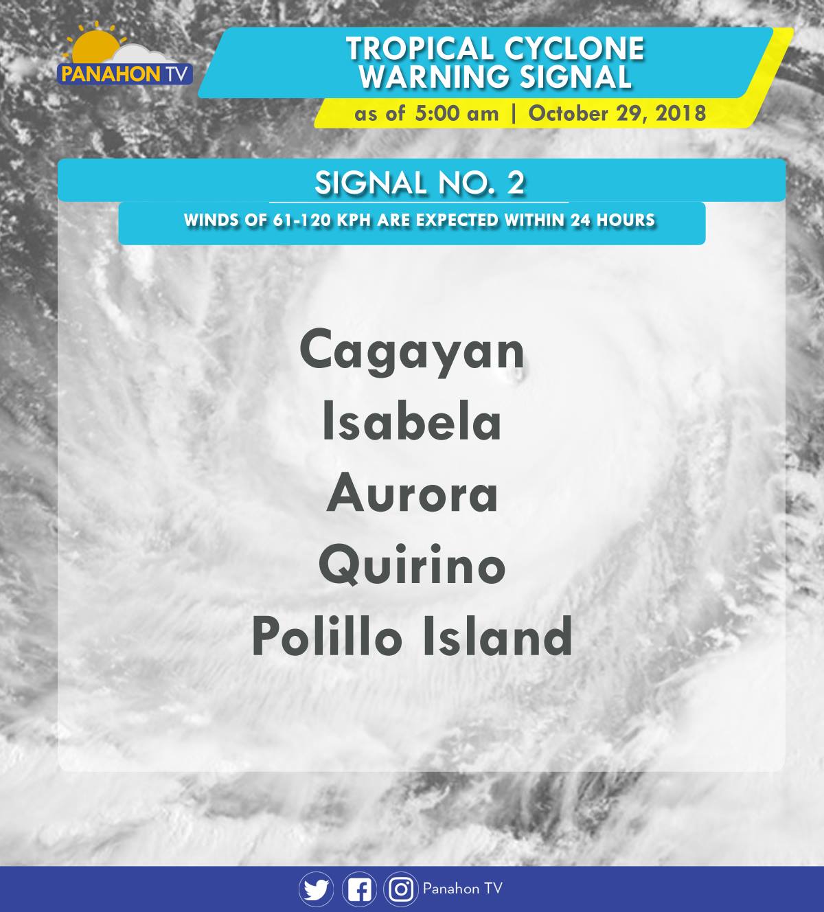
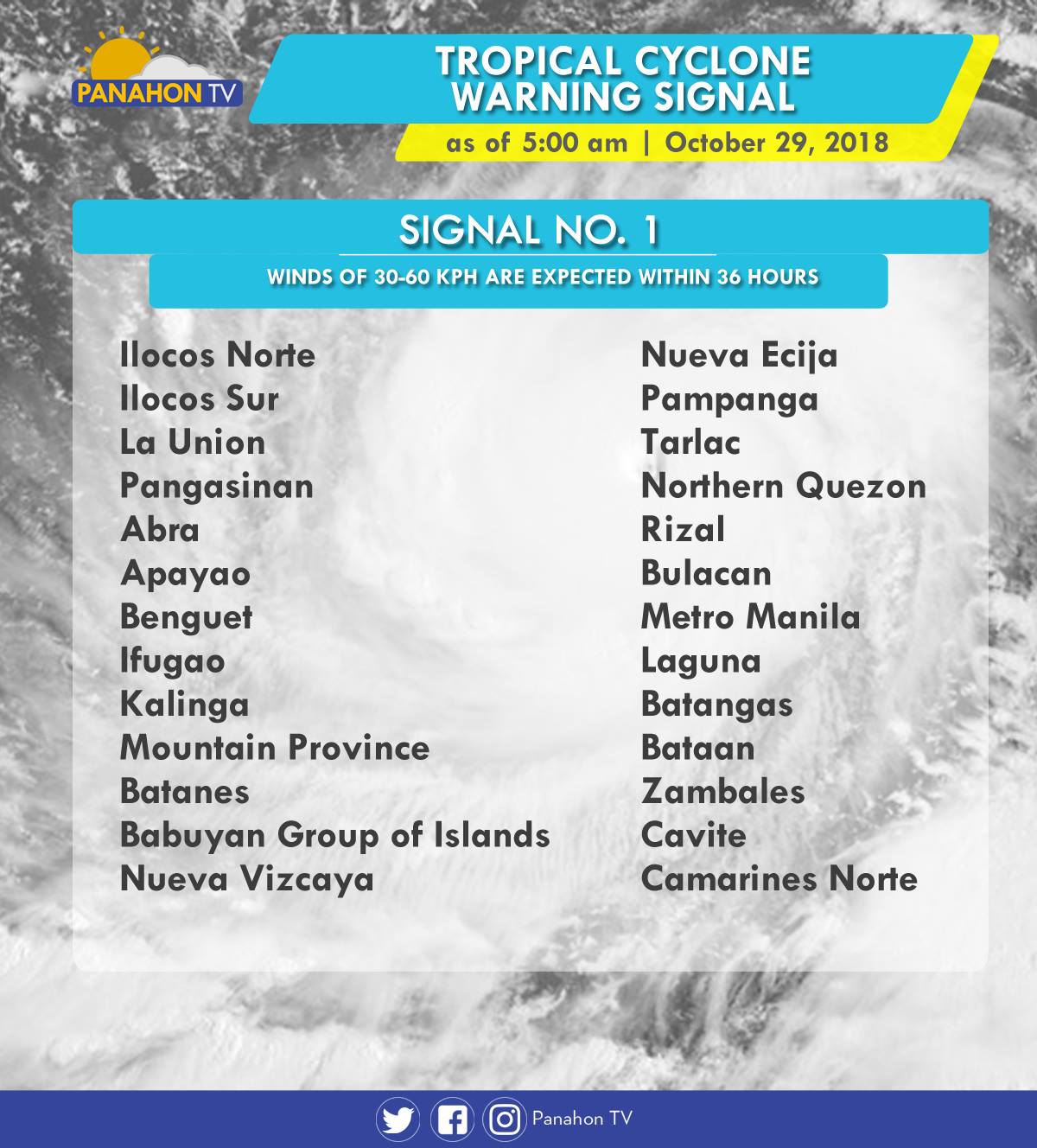
As Typhoon Rosita approaches the eastern section of Northern Luzon, Tropical Cyclone Warning Signals (TCWS) are raised by PAGASA in the following areas in preparation for incoming Typhoon.
In an Interview with PAGASA Weather Forecaster Ezra Bulquerin, he mentioned that the Typhoon may slightly weaken as it traverses the landmass of Northern Luzon. Although some parts of the country are already experiencing stormy weather, the Typhoon is expected to hit the landmass of Isabela-Cagayan later this evening. He also added that the Northeast Monsoon will not strengthen the Typhoon, but will only steer it toward Northern Luzon.
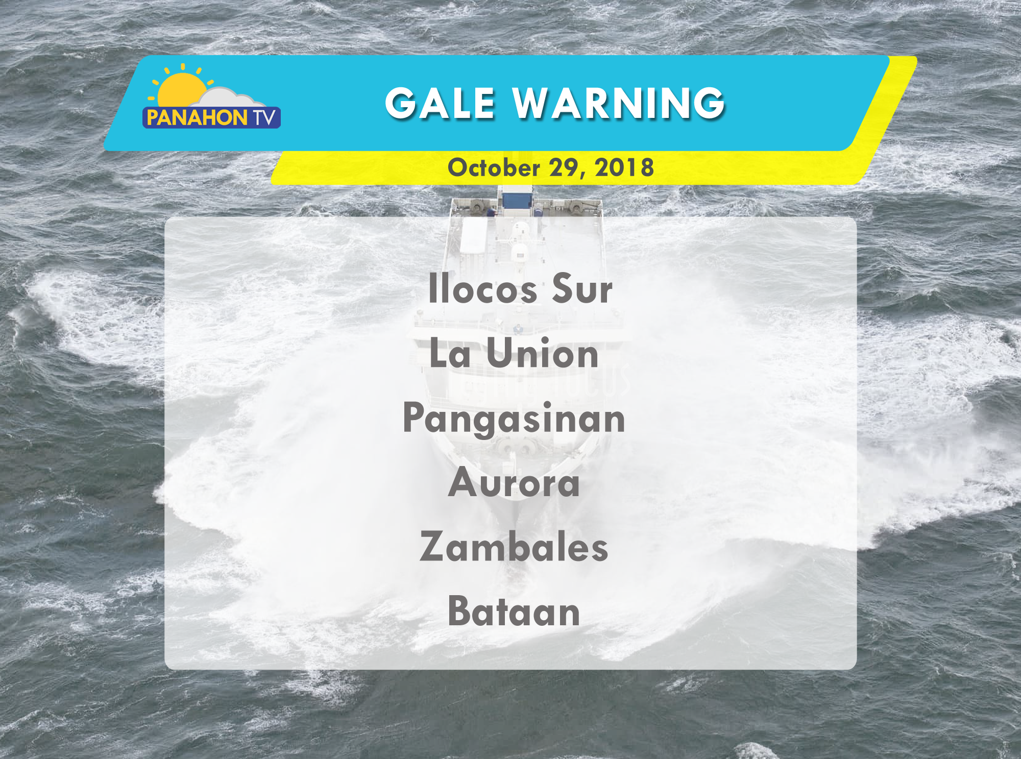
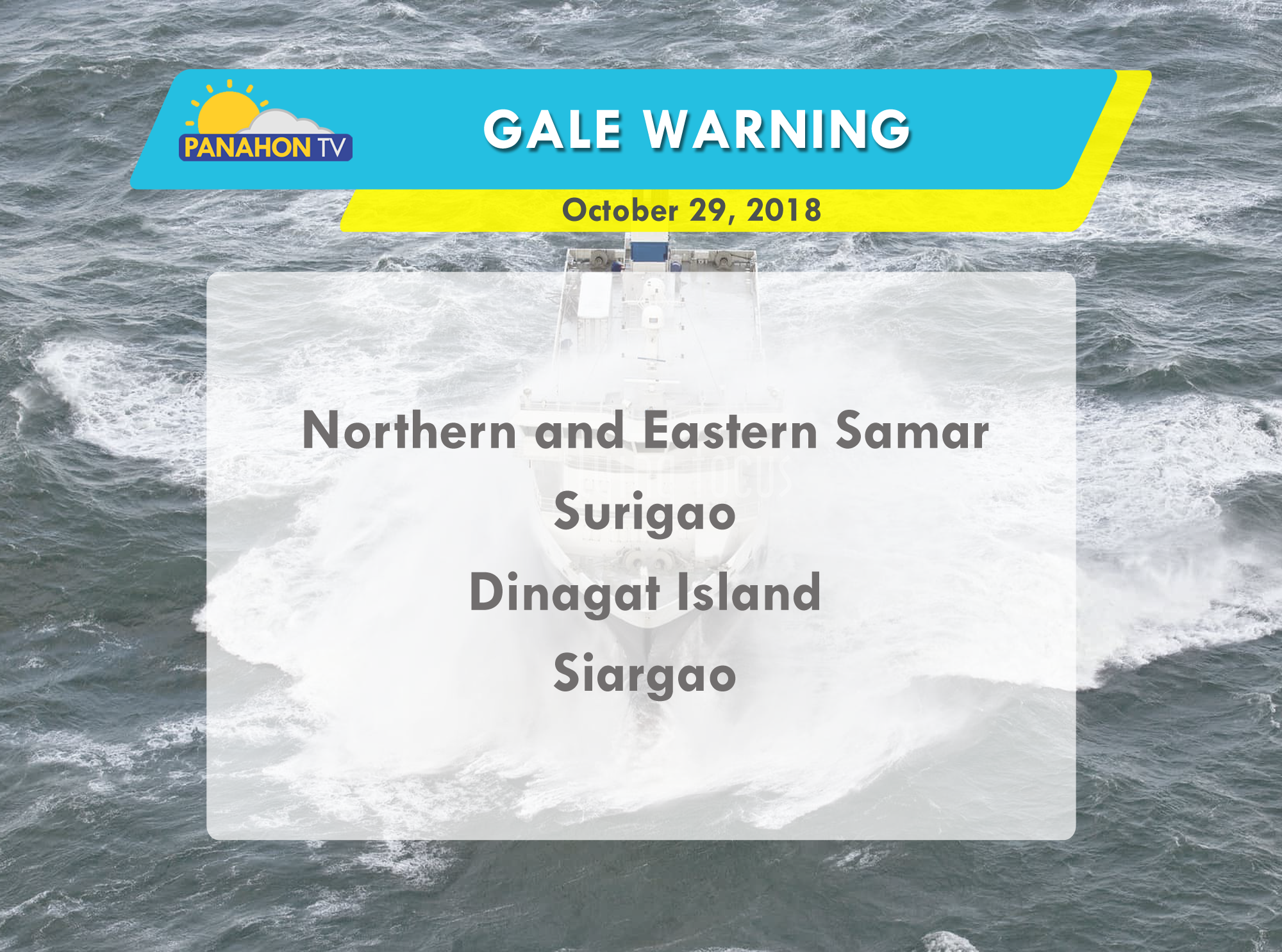
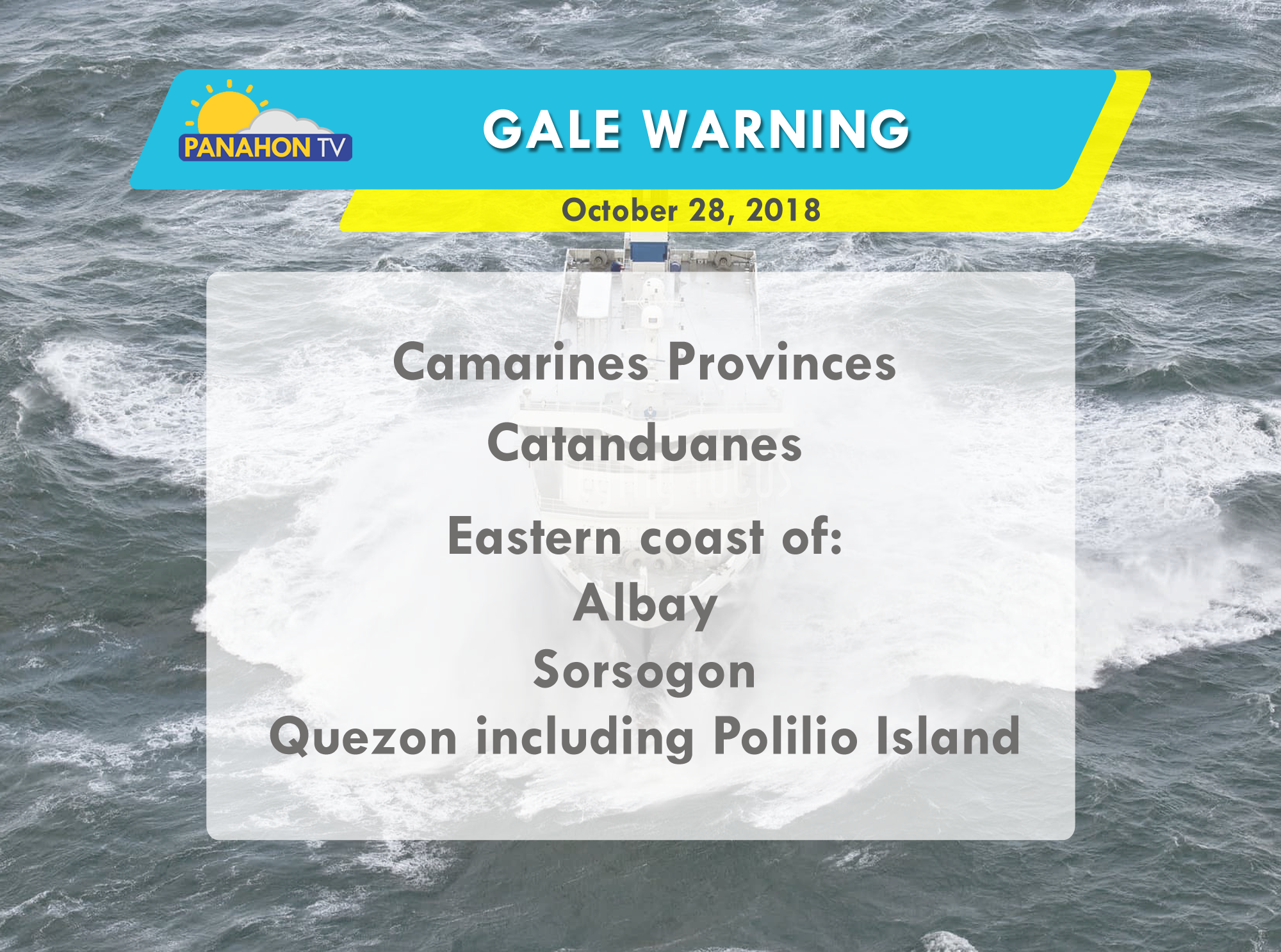
Due to strong waves brought by the Typhoon, gale warning is issued in the following areas:


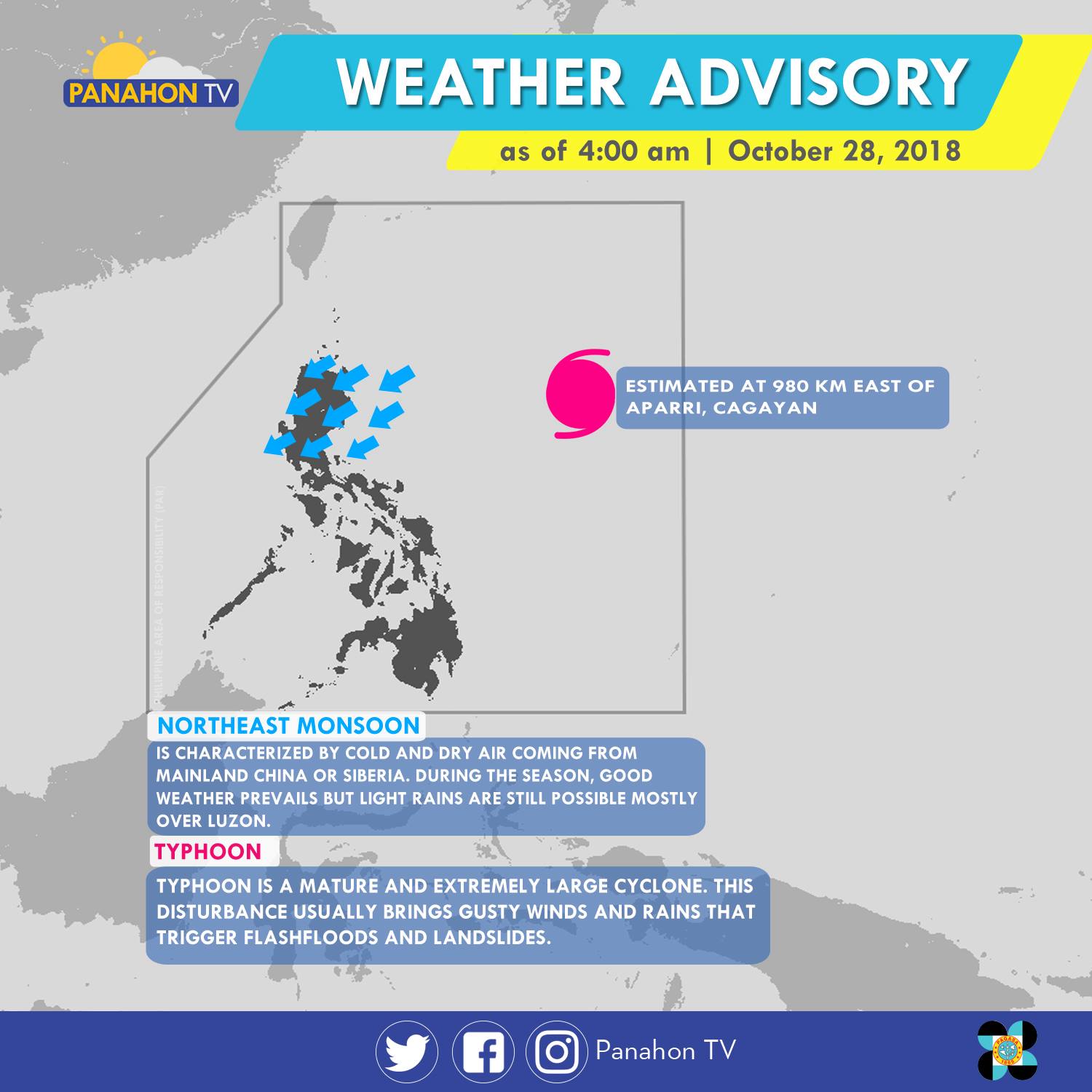
As of 4:00 a.m., Typhoon Rosita was last spotted 980 kilometers (km) east of Appari, Cagayan. With maximum sustained winds of 200 kilometers per hour (kph) and gustiness of up to 245 kph, it moves 20 kph westward. Meanwhile, the Northeast Monsoon or dry and cold winds coming from Siberia affects Northern and Central Luzon. It will bring cloudy skies with light rains in the Cagayan Administrative Region and Cagayan Valley. Meanwhile, partly cloudy to cloudy skies with isolated light rains are expected in Ilocos Region and Central Luzon. Metro Manila and the rest of the country will have partly cloudy to cloudy skies with isolated rain showers caused by localized thunderstorms.
According to PAGASA Weather Forecaster Meno Mendoza, Typhoon Rosita is expected to hit the landmass of Cagayan-Isabela by Wednesday afternoon. By Monday Tropical Cyclone Warning Signals (TCWS) are expected to be raised in Metro Manila and other parts of the country due to rains caused by the approaching Typhoon.

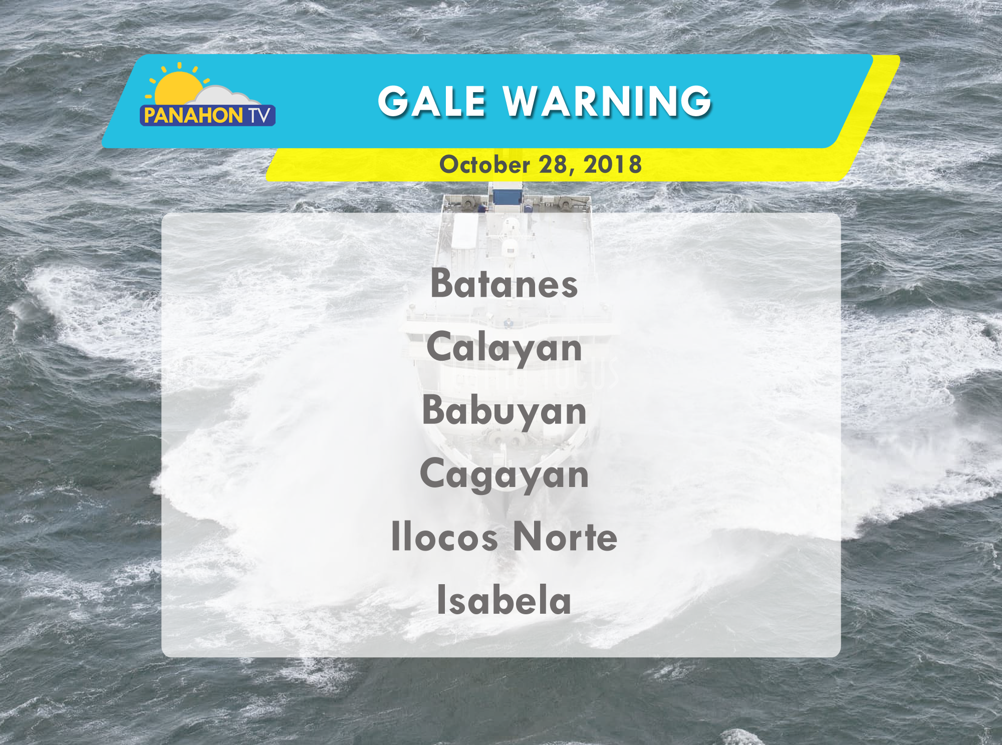
Due to strong waves brought by the Typhoon, gale warning is issued in the following areas.


Some areas in Northern and Central Luzon will continue to experience lights rains today.
According to PAGASA, the Northeast Monsoon or Amihan prevails in Northern Luzon, bringing cloudy skies with light rains in Cordillera, Batanes, Babuyan, Cagayan and Ilocos Norte. In Isabela, Aurora and Quezon, cloudy skies with scattered rain showers and isolated thunderstorms will be experienced due to the Tail-End of a Cold Front. In the rest of the country, including Metro Manila, partly cloudy to cloudy skies will be experienced but localized thunderstorms are still possible.
Because of the surge of Amihan, gale warning is still in effect off the seaboards of Northern Luzon where wave height may reach up to 3.4 to 4.5 meters. Fishing boats and other small seacraft are advised not to venture out into the sea, while larger sea vessels are alerted against big waves in Batanes, the Babuyan Group of Islands, Ilocos Norte, Ilocos Sur, the northern and eastern coasts of Cagayan, Isabela.
Supermoon brightened the sky
Last night, a larger and brighter moon graced the skies to the delight of selenophiles or moon lovers.
This astronomical event happens when the moon, at a full phase, coincides with the perigee or its closest distance to the Earth. Yesterday, the moon reached its perigee at 4:43 PM and its full phase at 11:47 PM. PAGASA said that the moon appeared 14% larger and 30% brighter than usual.
LOOK | Tonight's Supermoon as seen in Tanza, Cavite. The Moon reached its Perigee (its closest distance to the Earth) at 4:43 PM earlier. At 11:47 PM, it will reach a Full Moon phase and can appear up to 14% larger and 30% brighter than usual.Photos and video captured by Mary Crystalline T. Araracap
Posted by Panahon.TV on Sunday, December 3, 2017
Have you been complaining about the humid weather these past days? Well, the surge of the Northeast Monsoon may give you a break.
Yesterday, PAGASA recorded an air temperature of 36.5°C in Sinait, Ilocos Sur. With the humid weather, heat indices also continue to increase. Heat index refers to temperature obtained from the high air temperature and relative humidity. It also describes how the human body perceives the heat or the warm weather.

PAGASA Weather Forecaster Chris Perez reminded the public through an interview with Panahon TV that when the computed heat index value is between 30-40°Celsius, a person may experience exhaustion and stroke.

However, Amihan has slightly intensified today and is now affecting Northern and Central Luzon. This Tuesday, cloudy skies with light to moderate rains and isolated thunderstorms will prevail in the regions of Caraga and Davao. Cloudy skies with isolated light rains are also expected in the regions of Cagayan Valley and Cordillera, and the provinces of Aurora and Quezon. Partly cloudy to cloudy skies with isolated light rains will be experienced in the Ilocos Region and the rest of Central Luzon. Partly cloudy to cloudy skies with isolated rain showers or thunderstorms will prevail in Metro Manila and the rest of the country.
Strong to gale force winds associated with the surge of the Amihan are causing rough to very rough seas in the seaboards below. Fishing boats and other small seacraft are advised not to venture out while larger sea vessels are alerted against big waves.

PAGASA has yet to declare the start of the Hot and Dry Season but the heat has become increasingly intense in some parts of the country.
Yesterday, PAGASA recorded a scorching 36°C in Cabanatuan.

Today, a maximum of 34°C air temperature is expected in Metro Manila. For Baguio City, it will be between 16-26°C, 26-32°C in Iloilo and a maximum of 34°C in Zamboanga City.
While temperatures are expected to spike, the Northeast Monsoon in the Northern Luzon is still bringing cloudy skies with isolated light rains in Cagayan Valley Region. Partly cloudy to cloudy skies with isolated light rains will be experienced in the regions of Cordillera and Ilocos. Caused by the warm and humid air from the Pacific called Easterlies, partly cloudy to cloudy skies with isolated rain showers or thunderstorms will prevail in Metro Manila and the rest of the archipelago.
Despite the warm temperatures, gale warning is hoisted in the seaboards of Northern Luzon where sea travel may be risky due to rough to very rough sea conditions.

After bringing rains in the eastern portions of the country, the Low Pressure Area (LPA) inside the Philippine Area of Responsibility (PAR) has already dissipated.
The LPA entered PAR last Sunday, causing rains in Northern Mindanao, Caraga, Eastern Visayas and Southern Luzon before dissipating due to land interaction. However, based on PAGASA’s 11:00 AM weather update, leftover clouds from the LPA will still bring light to moderate rains in the Cordillera Administrative Region, Cagayan Valley and Aurora.

Partly cloudy to cloudy skies, only with isolated rain showers will prevail in Metro Manila and the remaining parts of Luzon, down to Visayas and Mindanao.
No gale warning was issued today but fisherfolk, seafarers and those who will travel in the seaboards of Northern Luzon are advised to take precautionary measures against moderate to rough sea conditions.
The Hot and Dry season may be around the corner but this doesn’t exempt the county from weather disturbances.
At 2:00 AM today, a Low Pressure Area (LPA) entered the Philippine Area of Responsibility (PAR). According to PAGASA Weather Forecaster Gener Quitlong, the LPA was located at 800 kilometers east of Hinatuan, Surigao del Sur at 4:00 AM. The LPA has yet to have any direct effect on the country but its extension will bring light to moderate rains in the Caraga Region today.

“Sa ngayon, within 24-48 hours hindi po natin ito inaasahan na magiging bagyo. Ibig sabihin hindi po favorable ‘yung environment. ‘Yun nga lang, lalapit po ito sa ating bansa at dadaan po sa Kabisayaan.” (We do not expect this to develop into a tropical cyclone within the next 24-48 hours due to the unfavorable environment. However, it will approach the landmass and will cross Visayas.)
Starting tomorrow, March 20, this weather system will bring cloudy skies with moderate to occasionally heavy rains and thunderstorms in the provinces of Surigao del Norte, Surigao del Sur, Agusan del Norte, Agusan del Sur and Northern Mindanao. Residents in these areas are alerted against possible flashfloods and landslides.
Meanwhile, theNortheast Monsoon is still dominant in Luzon where it will bring partly cloudy to cloudy skies with isolated light rains. For Visayas and the rest of Mindanao, partly cloudy to cloudy skies will prevail only with isolated rain showers or thunderstorms today.
Temperatures are beginning to rise in most parts of the country but the Northeast Monsoon, locally known as Amihan, has yet to end its dominance in Luzon.

This midweek Wednesday, Amihan has again intensified, affecting Northern and Central Luzon. As an effect, cloudy skies with light rains are expected in the Batanes Group of Islands. It will also bring partly cloudy to cloudy skies to the Ilocos Region, Cordillera, Central Luzon and rest of Cagayan Valley. In Metro Manila, the rest of Luzon, down to Visayas and Mindanao, generally fair weather will prevail only with chances of isolated rain showers or thunderstorms.
Despite the increasing temperatures in the country, PAGASA has yet to declare the commencement of the Hot and Dry season.
“’Yung warm and humid air ng Easterlies ang isa sa mga pangunahing characteristics para mag-declare po tayo ng tag-init. Hindi lang tayo makapag-terminate ng Amihan sa kadahilanang bumabalik ito.” (The warm and humid characteristics of Easterlies are one the factors before declaring the Hot and Dry Season. We can’t still announce it because Amihan has yet to be terminated.)
It can be recalled that PAGASA announced the termination of Amihan on March 18 last year, signaling the start of the Hot and Dry Season or tag-init.