Are you enjoying the cold weather? The early days of February brought in chilly temperatures, thanks to the northeast monsoon or amihan, characterized by cold and dry air coming from Siberia or Mainland China. According to PAGASA, the amihan season will last until the third week of the month. But aside from the cool relief the weather brings, it also comes with risks.
Sipon or Common Colds. Research shows that the cold virus survives and reproduces more effectively during this season, making it easier for it to spread and infect people. To reduce the risk of getting a cold, observe proper hygiene, such as washing your hands often with soap and water. Avoid touching your eyes, nose, and mouth with unwashed hands, and stay away from people who are sick.
Trangkaso or Flu. To avoid flu, short for influenza, avoid close contact with people who are sick, cover your mouth and nose when coughing or sneezing, and disinfect frequently-touched surfaces at home.
Asthma. Cold weather triggers asthma attacks because cold and dry air irritates the airways, causing their muscles to spasm. To prevent this, outdoor exercise should be limited.
Sore throat. Cold air usually dries out throat tissues, causing severe irritation. To avoid sore throat, frequently wash hands and sanitize frequently-touched things. Always cover both neck and head when going outside.
Dry skin. During this season, our skin’s moisture easily evaporates, making skin tight, flaky, and dry. To lessen the dryness, use moisturizers and gentle soap, and avoid bathing in hot water.
Whatever the weather is, make sure to observe proper hygiene, and take precautionary measures to lessen your exposure to viruses that may trigger these illnesses.
In the meantime, enjoy the sweater weather while it lasts!
Storm surges only entered the majority’s consciousness when Typhoon Yolanda devastated most of the Visayas, bringing 7-meter-high surges that claimed over 6,000 lives in Leyte and Samar in November 2013. The point cannot be emphasized enough: Storm surges can be fatal and we need to be prepared for them. Here’s a primer on one of the typhoon’s deadliest effects.
Top 5 Things You Need to Know about Storm Surges
1. A storm surge is not a tsunami. While a tsunami is a series of waves due to underwater seismic activities like earthquakes, a storm surge is the abnormal rise of seawater due to the low atmospheric pressure and strong winds brought about by a severe storm or typhoon. It may inundate low-lying coastal areas, resulting damage to properties, infrastructure and agriculture.
2. Storm surges can get pretty high. According to PAGASA, storm surges in our country may rise from an average of four to seven meters, which is equivalent to a 2-storey house, and may still intensify in the presence of high tide. Storm waves move as fast as seven meters per second, as fast as a golf ball driven off the tee, carrying small and large debris, which make them even more dangerous. When storm waves finally reach the ground, its speed becomes a little slower due to trees and other land structures.
3. Storm surges are deadlier in some areas than others. Studies say that storm surges may transpire in any seaboard affected by a severe storm, but the most devastating ones usually occur in our country’s southern and eastern seaboards. Eastern sections are typically flat and typhoon-frequented, making them prone to the surges.
4. Storm surges reoccur, especially in an archipelagic country like the Philippines. Eastern Visayas has been experiencing catastrophic storm surges for over a hundred years. On October 12, 1897 An Australian newspaper reported about a storm passing over Tacloban, the capital city of Leyte, claiming 7,000 lives. According to the Department of Science and Technology (DOST), the 1897 storm surge reached up to 7 meters, destroying churches and communities. In 1912, the front page of an American broadsheet featured a typhoon that injured and killed 15,000 people in Tacloban and Capiz. The DOST approximated the surge at four to nine meters tall.
5. More and more Filipinos face the risk of storm surges. The World Bank estimates more than 60% of our population live in coastal zones. In fact, the United Nations emphasized the swelling population of people residing in cyclone prone areas from 71.8 million in 1970 to 120.7 million in 2012. According to the National Geographic, the poor populace of the country has gradually moved to coastal islands, making a lot more people prone to the surges.
Now we know what storm surges are, how can we protect ourselves from them?
PREVENTIVE MEASURES AND SAFETY TIPS
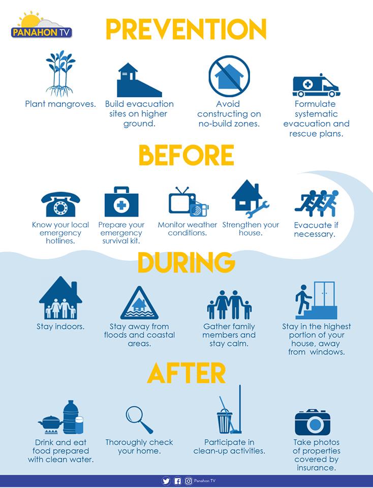
Plant trees. Plant mangroves and coconut trees along the shorelines, which may help shield the community from the waves brought by storm surges.
Avoid constructing on no-build zones. Know where the safe zones are by getting a hazard map from your barangay officers. A 40-kilometer buffer zone from the shore is advised in storm-surge prone areas.
Participate in community drills. Formulate systematic emergency, rehabilitation and relief distribution plans in your community. It is also essential to conduct a quarterly drill involving the children, youth, people with disability and senior citizens.
Plan with your family. Prepare a survival kit and a list of emergency hotlines. Discuss possible evacuation plans with your family and strengthen or fix your house if necessary.
Build evacuation sites on higher ground. Make sure that all evacuation areas are materially safe. Ensure safe routes and build directional signages going to the location.
Monitor weather conditions. Always be updated on news and announcements via radio, television and social media.
Stay Indoors. Stay in the highest portion of the house or building, away from the windows.
Evacuate if advised. Evacuate before the surge transpires, but if some members of the family have not yet arrived, call them or leave a note to inform them of your location. Switch off electricity, the waterline and gas tank. Make sure that all windows, cabinets, doors and gates are closed and locked before leaving.
Stay away from flooded areas and shorelines. Never attempt to pass a swollen river and avoid routes along the sea.
Follow the rules in evacuation sites. Do not litter, vandalize or destroy anything in the area. Observe proper hygiene to avoid illnesses and maintain peace and order in your area.
Here’s what else you need to do in the wake of a storm.
Sources: PAGASA-DOST, PROJECT DINA & Project NOAH
Warm Wednesday and Monsoon Break
In the midst of the Rainy Season, generally fair and warm weather is expected with the presence of the Ridge of a High Pressure Area (HPA) today.
“Ridge” refers to the extended part of an HPA or an anticyclone. Unlike a Low Pressure Area, this indicates an area where the atmospheric pressure is higher than its surroundings. Formation of clouds is usually suppressed, thus, less chance of rains. As it extends across Luzon, partly cloudy to cloudy skies will prevail in Metro Manila and the rest of the country only with isolated rain showers or thunderstorms.
In an interview with PanahonTV, PAGASA Weather Forecaster Robert Badrina said that the country is on a monsoon break.
Badrina also said that the country will experience a storm-free week.
Potential LPA spotted
A possible weather disturbance was spotted in Mindanao today.
Based on an interview with PAGASA Weather Forecaster Meno Mendoza, the possible Low Pressure Area (LPA) is embedded along the Intertropical Convergence Zone or ITCZ.
“Ang nakapaloob dito sa ating Intertropical Convergence Zone ay mga maliliit na vortices ng Low Pressure Area at posible itong panggalingan nga ng sama ng panahon.” (Embedded within the Intertropical Convergence Zone are small vortices of Low Pressure Area, which may develop into a weather disturbance.)
Considered to be a breeding ground of weather disturbances, the ITCZ refers to the area where winds from the Northern and Southern Hemispheres meet and create interaction. Meanwhile, vertices are mass of whirling air that may develop into weather disturbances.
Today, Mindanao and Eastern Visayas will continue to experience light to moderate rains and thunderstorms this Thursday. In the rest of the country including Metro Manila, partly cloudy to cloudy skies will prevail with isolated rain showers or thunderstorms.
ITCZ soaks parts of Mindanao
The Intertropical Convergence Zone (ITCZ) continues to affect Southern Mindanao.
ITCZ is characterized as an area where winds coming from the Northern and Southern Hemispheres meet; this interaction results to rains in the affected areas.
As this weather system prevails, cloudy skies with light to moderate rains and thunderstorms will be experienced in Mindanao today. Rains have been affecting the region since last week, prompting the cancellation of classes and declaration of State of Calamity in Kabuntalan and other areas in Maguindanao due to widespread flooding.

Light to moderate rains will also affect the regions of Central Visayas and Negros Island. In the rest of the country including Metro Manila, partly cloudy to cloudy skies will prevail only with isolated rain showers or thunderstorms.
Moderate rains continue in Palawan
The Southwest Monsoon, locally known as Habagat continues to affect the eastern section of Luzon.
As this weather system prevails, Palawan will continue to experience light to moderate rain showers and thunderstorms. In the rest of the country including Metro Manila, partly cloudy to cloudy skies will prevail only with isolated rain showers or thunderstorms.
With rains concentrated in Palawan, humid weather is still expected to prevail in most parts of the country.

Get to Know Habagat
Every year, when the rainy season begins, Habagat begins to affect the country. Due to its warm and moist characteristics, Habagat causes monsoon rains that could last for a couple of days or even a week. Here are things you must know about this weather system:
Light to moderate rains in Palawan
On the first Saturday of June, the Southwest Monsoon, which is warm and moist air locally known as Habagat is still affecting the western section of Luzon.
As this weather system prevails, cloudy skies with light to moderate rain showers and thunderstorms will be experienced in the province of Palawan. In Metro Manila and the rest of the country, partly cloudy to cloudy skies with isolated rain showers or thunderstorms will prevail.
While the Habagat dumps rains on some parts of Luzon, residents are alerted against heavy rains, which may trigger flash floods and landslides. It can be recalled that five persons perished in a landslide that occurred in Puerto Princesa City, Palawan last Monday night. According to reports, the victims were composed of a family of four and an infant.

Photos courtesy of Brigada News FM Palawan.
However, PAGASA Weather Forecaster Meno Mendoza clarified that there is no weather disturbance affecting the country.
https://www.youtube.com/watch?v=MIE_MuLGYuQ
This weekend, remember to bring your umbrellas as you make your “huling hirit sa tag-init,” because the prevailing Southwest Monsoon or Habagat brings possibilities of rains. According to PAGASA Weather Forecaster Loriedin dela Cruz, the habagat is in effect in the western section of Luzon and Visayas.
With its warm and moist characteristics, the habagat will bring cloudy skies with light to moderate rain showers and thunderstorms to the regions of Ilocos, Cordillera, MIMAROPA, CALABARZON, Bicol, Western Visayas and the provinces of Batanes, Cagayan, Zambales and Bataan. In the remaining parts of the country including Metro Manila, partly cloudy to cloudy skies prevails only with isolated rain showers or thunderstorms.

Photo courtesy of Nelson M. Velasco, Daraga, Albay
Dela Cruz adds that no weather disturbance is expected to affect the country in the next two days.
After soaking portions of Mindanao these past days, the Intertropical Convergence Zone (ITCZ) has oscillated southward, reducing its effects on the region.
While it has been warm and humid in Luzon and Visayas since last week, the ITCZ, known as the breeding ground of Low Pressure Areas (LPA), brought rains in several areas in Mindanao. Landslides have transpired in Kapatagan, Lanao del Norte and Brgy. Napangan in Don Victoriano, Misamis Occidental because of heavy rains last Sunday.


Photos from Don Victorino Disaster Risk Reduction and Management Office.
Because of the prevailing Easterlies or warm and humid air from the Pacific Ocean, Mindanao weather is expected to improve. This Tuesday, cloudy skies with light to moderate rains and isolated thunderstorms will be experienced in the Davao Region. In Luzon, Visayas and the rest of Mindanao, generally fair weather will prevail except for isolated rain showers or thunderstorms.
Temperatures are still expected to soar with the highest heat index possible in Tuguegarao.
