Temperatures are beginning to rise in most parts of the country but the Northeast Monsoon, locally known as Amihan, has yet to end its dominance in Luzon.

This midweek Wednesday, Amihan has again intensified, affecting Northern and Central Luzon. As an effect, cloudy skies with light rains are expected in the Batanes Group of Islands. It will also bring partly cloudy to cloudy skies to the Ilocos Region, Cordillera, Central Luzon and rest of Cagayan Valley. In Metro Manila, the rest of Luzon, down to Visayas and Mindanao, generally fair weather will prevail only with chances of isolated rain showers or thunderstorms.
Despite the increasing temperatures in the country, PAGASA has yet to declare the commencement of the Hot and Dry season.
“’Yung warm and humid air ng Easterlies ang isa sa mga pangunahing characteristics para mag-declare po tayo ng tag-init. Hindi lang tayo makapag-terminate ng Amihan sa kadahilanang bumabalik ito.” (The warm and humid characteristics of Easterlies are one the factors before declaring the Hot and Dry Season. We can’t still announce it because Amihan has yet to be terminated.)
It can be recalled that PAGASA announced the termination of Amihan on March 18 last year, signaling the start of the Hot and Dry Season or tag-init.
They looked like beings from another world. Fish that’s almost ten times the average Filipino height.. An unidentified hairy carcass washed ashore.
Such sea creatures are not only mysterious-looking, but are said to hold the key to the mystery of predicting earthquakes. How? Since these animals live in the deep sea, some believe that they feel the shifting of the ground before we do, and that when they suddenly pop into shallow waters or the surface, it means that their habitat was disturbed—indicating an impending earthquake.
Here are some of the alleged instances:
OARFISH
Weeks before a magnitude 6.7 earthquake struck Surigao, sightings of oarfish were observed in Agusan del Norte. A 10-foot long oarfish was found in Carmen, Agusan del Norte, approximately 168 kilometers away from Surigao City.
The oarfish, considered as the world’s longest bony fish, usually stays in depths between 1,000 to 3,000 feet below the sea surface. This type of fish can grow up to 50 feet long. According to some scientists, these deep-dwelling species may crop up occasionally due to strong currents.
After the strong earthquake in Surigao, other sightings of oarfish also happened in Cagayan de Oro and Misamis Occidental.

SUNFISH
On the 22nd of February this year, a sunfish was seen in the shore of Balingasag, Misamis Oriental. The locals who have first witnessed the fish said it was still alive when they saw it but had later weakened and died.
In February 27, a sunfish measuring 147 centimeters long and 85 centimeters wide was spotted in the waters off Barangay Sangali, Zamboanga City.
Something unusual on the first of March welcomed the residents of Marinduque. A very large sunfish was found in the town of Boac. Local officials will have to investigate further due to the deep wound found on the sunfish, which might have been caused by parasitic worms.
According to the National Geographic, the sunfish is the heaviest bony fish and are generally found in the deep waters.
Speculations that the emergence of the sunfish is related to the ground shaking in Mindanao caused the residents to become a bit agitated.

GLOBSTER
A lifeless hairy blob or globster was found on the Dinagat Islands on February 22. A globster is an unidentified organic mass that washed up on the shoreline. The large sea creature could not be identified because it was already at its decomposition stage but some believed that the carcass is likely to be that of a sea cow.
Because of the proximity of Dinagat Islands to where the recent magnitude 6.7 earthquake transpired in Surigao,locals speculated this huge white beast went ashore because of the powerful tremor.

Quake Country
Apart from an average number of 19 to 20 tropical cyclones each year, the Philippines is also prone to earthquakes because it’s within the Pacific Ring of Fire. The most recent massive tremor in the country is the magnitude 6.7 earthquake that jolted several parts of Mindanao at around 10:03 PM on February 10, 2017. At a shallow depth of 10 kilometers, the epicentre was located at 16 kilometers offshore northwest of Surigao City.
The ground shaking was felt in Surigao City and San Francisco, where Intensity 7 was recorded. The rest of the municipalities in Surigao del Norte experienced Intensities 4, 5 and 6. To date, more than 200 aftershocks have beenrecorded by the Philippine Institute of Volcanology and Seismology (PHIVOLCS). The largest of these rocked the same location on March 5, 2017 at 8:08 AM. With a depth of 10 kilometers, the epicentre of the magnitude 5.9earthquake was plotted at 80 kilometers west of Surigao City.
As of March 8, the latest report from the National Disaster Risk Reduction and Management Council (NDRRMC) showed a total of 38, 245 persons affected in 82 barangays of Surigao del Norte. Eight people died from the recent powerful earthquakes while more than 230 people were injured. More than 7 thousand houses and 47 school facilities were damaged.
Surigao Earthquake Explained
According to PHIVOLCS, Eastern Mindanao, including Surigao del Norte, is a seismically active area because of the Philippine Fault and Philippine Trench.
This is not the first time that Surigao experienced enormous earthquakes. A magnitude 7.4 tremor rocked the Surigao segment of the Philippine Fault on July 1, 1879. This was considered the largest historical earthquake in Surigao where ground shaking was felt in the entire province, causing huge damage to infrastructure, widespread liquefaction and landslides.
Can we predict earthquakes?
These strange deep-sea creatures that are recently surfacing in shallow waters have created quite a stir among the residents, sparking discussions on social media. Many people feared that the mysterious sea creatures were omens of horrendous events.
Is it true that the appearance of these sea creatures point to an impending disaster? Here are what the experts have to say:
“Kung pag-uusapan ang recent sea creatures na natagpuan sa bansa, walang basehan na kaya nitong magpredict ng lindol. Totoong minsan ay may kakaibang kilos ang mga hayop pero dapat pinapakita ito ng marami at dun mismo sa panggagalingan ng lindol. So, hindi lahat ng animal behaviour ay mairerelate sa earthquakes.”
Ang kailangan natin ngayon ay paghahanda. Makakaligtas ka sa lindol kung una, sisiguraduhin mong matibay ang iyong bahay. Pangalawa, alam mo kung ano ang gagawin kapag tumama ang lindol. ‘Yung duck, cover & hold. At ikatlo, alam mo at ng mga tao sa iyong komunidad kung paano ang mabilis at tamang pag-respunde gaya ng evacuation at first aid…mahalagang mapag-aralan ‘yan.”
(There is no scientific basis that animals, particularly sea creatures, can predict earthquakes. Animals may have unusual behaviour but not everything is related to the occurrence of earthquakes.
What we need to do now is to be fully prepared. To survive an earthquake, make sure that your house is strong enough to withstand huge earthquakes. Second, you must know what to do during an earthquake. Always remember the duck, cover & hold. Lastly, educate yourself with the proper response and rescue procedures.)
– Dir. Renato Solidum
PHIVOLCS Director / DOST Undersecretary
“This is not a way to predict earthquakes,” Dukes said. “It’s just a way to warn that the Earth is moving and something — an earthquake, or a landslide or something else — might follow.”
– Catherine Dukes
Researcher, University of Virginia
“Animal behavior is not always predictable — for the earthquake forecasting side of things we would still need to have geophysical measurements in combination with animal measurements.”
– Dr Rachel Grant,
Lecturer, Animal and Environmental Biology (Anglia Ruskin University)
“These are just old superstitions and there is no scientific relationship between these sightings and an earthquake.”
– Hiroshi Tajihi
Kobe Earthquake Center
So the next time you hear about the appearance of such creatures, remember that panic is not the right response. What we must constantly do is preparation; even without the surfacing of these mysterious-looking sea animals, we must be always be ready for the possibility of disasters.
Sources:
PHIVOLCS – DOST
BFAR
NDRRMC
Live Science
http://edition.cnn.com/2015/04/03/tech/mci-earthquake-animals/
Sunstar Cagayan De Oro
Rains caused by the Low Pressure Area (LPA) are likely to continue in several areas in the southern parts of the country today.
At 11:00 AM today, the LPA was spotted at 135 kilometers southeast of General Santos City. Compared to previous days, the effects of this weather disturbance have already weakened. However, it will still bring cloudy skies with light to moderate rains and isolated thunderstorms in Visayas and Mindanao.

In an interview with PanahonTV, PAGASA Weather Forecaster Sheila Reyes said that the LPA has slim chance of developing into a tropical cyclone or “bagyo.”
]
Meanwhile, the Northeast Monsoon still persists in Northern Luzon. It brings partly cloudy to cloudy skies with isolated light rains in the regions of Cagayan Valley, Cordillera and Ilocos. Partly cloudy to cloudy skies with isolated rain showers or thunderstorms also prevail in Metro Manila and the rest of Luzon.
The shortest month of the year is about to end. But before we bid goodbye to the Love Month, let’s take a look at February’s weather highlights.
Five different weather systems prevailed in the country this February. These include the Trough of a Low Pressure Area (LPA), Tropical Depression Bising that recurved without hitting the landmass, the Tail-end of a Cold Front that brought moderate rains in portions of Visayas and Mindanao, the Northeast Monsoon that caused cold days, and the Easterlies which now signals the transition to the Hot and Dry season.
As Amihan peaked this month, temperatures also dropped most especially in the Northern Luzon.

According to PAGASA Weather Forecaster Chris Perez, the Northeast Monsoon is now gradually weakening, signaling the arrival of the Hot and Dry Season.
“Overall, nakikita nating patuloy na umiinit ang antas ng temperatura sa nakararaming bahagi ng ating bansa maging dito sa Metro Manila. Pumapasok na tayo na rin ang hangin mula sa silangan o Easterlies na naghuhudyat na posibleng magtapos na ang Amihan ngayong unang linggo ng Marso at posibleng mapunta na tayo sa tinatawag nating transition towards the warm months.” (Overall, we are observing higher temperatures in most parts of the country including Metro Manila. Easterlies have also set in, marking the possible termination of the Northeast Monsoon by the first week of March and the transition to the warm months.)
WEATHER TODAY
Today, the Northeast Monsoon has slightly weakened and is now dominant in Northern Luzon. Meanwhile, the eastern sections of Southern Luzon, Visayas and Mindanao are being affected by Easterlies.
Cloudy skies with light rains will be experienced in Cagayan Valley. In Metro Manila and the rest of the country, partly cloudy to cloudy skies will prevail with isolated rain showers or thunderstorms.

After bringing rains in Bicol Region, portions of Visayas and Mindanao, Tropical Depression Bising has weakened into a Low Pressure Area (LPA).
At 4:00 AM today, the LPA was estimated at 725 kilometers east of Juban, Sorsogon. In the next hours it will still bring cloudy skies with light to moderate rains and isolated thunderstorms in Eastern Visayas, Caraga and the province of Palawan.

Meanwhile, the Northeast Monsoon in Northern and Central Luzon will cause cloudy skies with light rains in Cagayan Valley. In Metro Manila and the rest of Luzon, partly cloudy to cloudy skies with isolated light rains will prevail. Generally fair weather will be experienced in the rest of Visayas and Mindanao only with isolated rain showers or thunderstorms.
PAGASA earlier explained that Bising recurved due to the strong wind shear near the Philippines, pushing tropical cyclones away from the landmass.
Strong to gale force winds associated with the surge of the Northeast Monsoon are also bringing rough to very rough seas in these provinces:

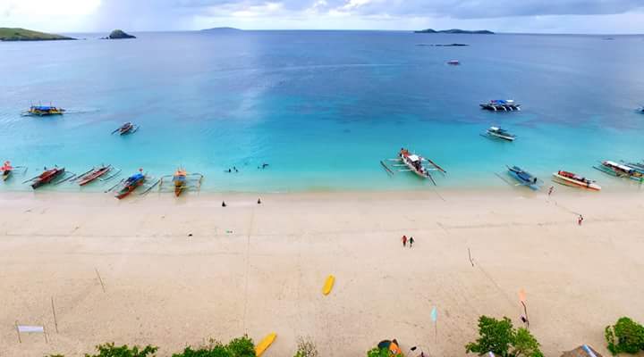
Mere Miles and Smiles Away: Calaguas Island
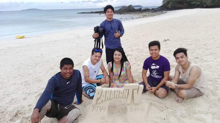
As an intern from PanahonTV, I never thought I would get to go on an awesome out-of-town trip. Thankfully, I found out the show tackled, not just all things about the weather, but a slew of other topics such as daily life hacks, the environment, and our culture.
This month, I found myself en route to Daet in Camarines Norte with the production crew to cover the Pinyasan Festival 2016. An annual event that highlights the “sweetest pineapple in the world,” the Queen Formosa variety, the festival includes various activities, such as the Kasalang Bayan, sportsfest, beauty pageant, and the Agricultural Night.
Throughout the years, the Camarines Norte province has gained recognition as housing some of the most beautiful spots in the Philippines. These include Bagasbas Beach, one of the country’s top surfing destinations; Apuao Grande Island; and the much talked-about Calaguas Group of Islands. With the islands’ pristine and powdery-white shores and crystal-clear blue waters, many have compared it to Boracay.
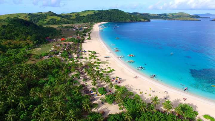
Aerial Shot by Kent Eribal
Fast Facts about Calaguas
- The Calaguas Group of Islands is composed of 21 islands and islets, only two of which are under the jurisdictions of the towns of Vinzon and Paracale.
- The islands’ names are the following: Tinaga, Balagbag Maliit, Balagbag Malaki, Sepia Maliit, Sepia Malaki, Bendita, Huag Maliit, Huag Malaki, Comalasag, Inggalan, Pinagcastillohan, Banocboc, Samung, Pinanakpan, Matandumatin Rock, and Kagtalisay. The other islands remain unnamed.
- Tinago island has a 1.27-kilometer stretch of powdery white sand called Mahabang Buhangin. There’s no phone signal in the area, but according to our travel guide, Infanta Quezon Councilor L.A. Ruanto, there’s a particular area on the hill, which can allow Smart subscribers to use their phones. Electricity is available from 10 PM to 6 AM.
taken by Kent Eribal
Tinago Island Activities
Hiking to Tinago Hill
To fully appreciate the island, a trek to the top of Tinago Hill is a must. Aside from catching that elusive Smart Signal, you’ll also be treated to a breathtaking view of the island. The hiking time will take about 20-30 minutes before you get to the top. Remember to bring water and to wear comfortable shoes, clothes and hats. Also, make sure you’re accompanied by a local guide.
Camping
We stayed at I Love Calaguas Resort, which offers group accommodations that range from P3,500 to P4,500. But if you want a more intimate experience with nature, try sleeping under the stars by renting a tent for only P350 (good for 2-3 persons).
Beach Volleyball
Play a round of beach volleyball to work up a sweat and an appetite. Volleyball is even more challenging when done on the beach, with your feet sinking into the sand. But it’s arguably safer because the soft sand can cushion your fall.
Island Hopping
Aside from the well-known Mahabang Buhangin in Tinago Island, there are other beaches and islands worth exploring.
- Maculabo Island – An unspoiled island that offers activities, such as scuba diving and fishing, which are part of the locals’ livelihood.
- Guintinua Island – also known for its long stretch of beach with powdery white sand and clear waters
How to get to Calaguas from Manila
Buses bound for Camarines Norte can be found at the Alimall Bus station in Cubao, Quezon City, and along the EDSA Highway. Look for a bus bound to Paracale or to Daet. You may find destinations at the Philtranco station in Pasay.
Air-conditioned bus fares range from P500-P600, while the regular ones range from P300-P400. Travel time is 8-9 hours.
The port at located at Minaoagan in Vinzons, Camarines Norte. According to Councilor Ruanto, the best time to travel to Tinago Island would be in the morning until 12 noon wherein the sea is at its calmest.
Because we arrived at the port at 1 pm, the waves were already high, prolonging our boat ride to 2 and half hours—30 minutes more than the usual duration. Boat fees are P3,000 (5-6 persons) and P4,000 (9 persons).
 Photo taken by John Estrada

Touchdown at Tinago Island ; photo by George Gamayo
Photo by John Estrada

Photo by Kent Eribal
We stayed at I LOVE CALAGUAS resort, one of the seven resorts that offer accommodation in Tinago Island.
According to Bgy. Capt. Ariel Era, the sand darkens during the rainy season.
Sand Artist Ruel Santelices is at the Kagedama resort every weeken; Photo taken by (please put name of driver);

Photo by Ruel San Telices
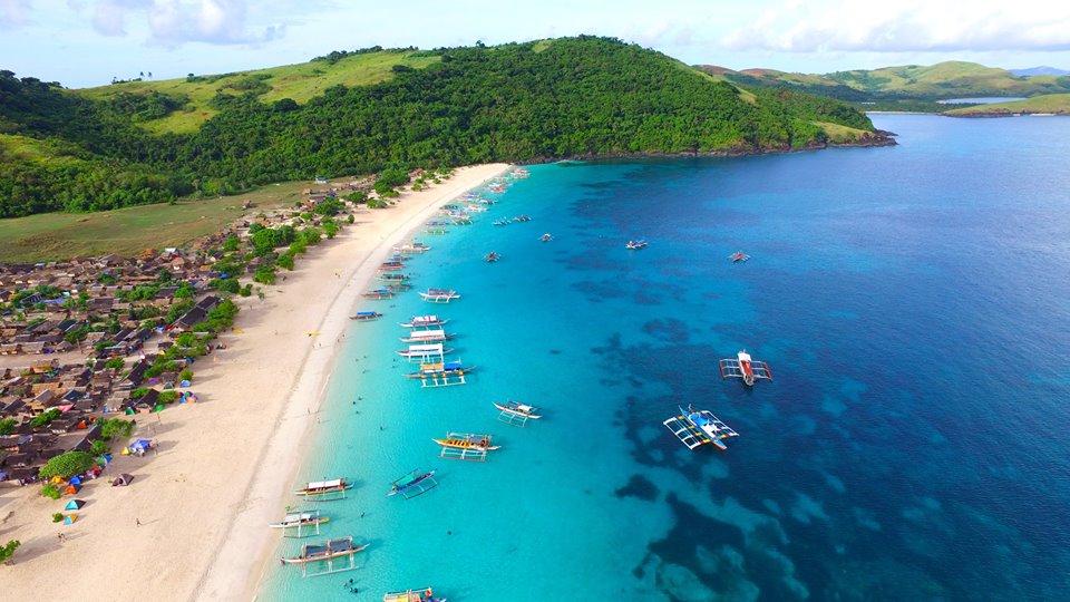
Photo Taken by Kent Eribal
What to bring to Calaguas
- Sunblock
- Sunglasses
- Camera (and waterproof bag)
- Slippers and shoes that are good for trekking
- Towel
- Cap
- Mosquito repellant
- Toiletries
- Plastic bags to waterproof your belongings
For more information and inquiries about expenses and details, visit these travel agency websites: www.northlinkph.net and www.calaguasadventure.net.
What I will always remember about my Calaguas Trip is that every moment was Instagram-worthy. It was as if everything was put in its proper place—the sand, the hills, the sea, the sky. And it got me thinking, that’s nature for you! That’s why it’s our duty to make sure that places like this maintain their natural beauty. I couldn’t bear thinking such magnificence falling to ruin just because of our negligence.
Photo of George Gamayo
Photo Taken by John Estrada

Photo Taken by Kuya Benjie
Sources:
Ruel San Telices – Sand Artist
Darius Mirasol – LGU officer
http://www.thepinaysolobackpacker.com/calaguas-island-travel-guide/
http://www.lakwatsero.com/spots/maculabo-island/
https://gelyks.wordpress.com/2015/11/17/maculabo-island-in-paracale-camarines-norte/
Blessed with scenic spots and beautiful people, the Philippines is undoubtedly a world-class paradise! But with these treasures come the hazards the country is prone to; each year we face an average of 19 to 21 tropical cyclones, frequent earthquakes and occasional volcanic activities.
One such event happened on June 15, 1991 when Mount Pinatubo erupted, claiming hundreds of lives. After being dormant for around 600 years, its eruption was believed to be triggered by a massive earthquake known as the “Great Luzon Quake” that struck the northern and central parts of Luzon in July 1990.
Considered one of the most destructive volcanic eruptions of the 20th century, the Pinatubo event produced thick deposits of tephra, pyroclastic stream flow and lahar, which were aggravated by Typhoon Yunya, locally named as Diding.
Based on the records of PAGASA, the tropical cyclone developed east of Samar and crossed Luzon before exiting the Philippine Area of Responsibility (PAR). According to PAGASA Weather Forecaster Buddy Javier, heavy rains and strong winds worsened the lahar flow in affected communities. The combined effect of lahar spewed by the volcano and flooding from the typhoon submerged almost a million houses.
After the dreadful event, a lake was formed within the crater of the volcano. Now dubbed as a “beautiful disaster”, the Pinatubo eruption created an amazing view that continues to stun both local and foreign visitors.
Journey to the crater
Just in time for the commemoration of the Pinatubo eruption’s silver anniversary, the Panahon TV team produced a special segment, not only to commemorate the tragedy, but also to highlight the lessons that the Filipinos learned from it. We were five in the group composed of myself, the segment producer, coordinators, and a cameraman.
It was on a Saturday, at around 2:00 AM, when we assembled at the PAGASA Weather and Flood Forecasting Center, where our media van awaited to bring us to Tarlac.
We departed at 2:30 AM. Though a bit sleepy, everyone was excited for the trip! After approximately two and a half hours, we finally reached Brgy. Sta. Juliana, the trek’s jump-off location. We were able to meet other trekkers though I noticed that we were not as many as expected.
One of the tourism officers said though the average number of visitors during weekends usually plays between 200 to 250, the number of tourists has dwindled from 400 to 650. According to a local, it was probably because of the additional fees that were being collected recently—something we discovered first-hand later on.
At the jump-off site, we were welcomed, not only by the organizers and tourism officials, but also kids selling trekking sticks made from wood. I bought one from a little girl for only P20. I hoped it would give me stability while trekking on a rough terrain.
Comfort rooms made from nipa are also provided at the site so you can change clothes before starting the tour. After the briefing and distribution of food, we returned to the road with our driver and guide.
Aboard the 4×4 vehicle, we were introduced to our driver, Mang Felix, and Kuya Jimmy, our tour guide. We found out that they were among the survivors of Pinatubo’s wrath.
The dusty 4×4 trip started easily enough. But as we draw nearer to the site, the path became rougher and wetter! The flowing streams were run through without mercy, so we were treated to a slightly messy and wet ride.
We had our first stop over at what they called “Toblerone.” Does it look familiar, chocolate lovers?

The little Aetas were also there to welcome the tourists. They greeted and even joined us in our photos.

We resumed our ride and after almost two hours, we reached the parking stop. After unloading the 4×4 vehicle, we started walking—the official start of our journey to the crater.

Along the rocky trail, we noticed rock balancing displays built by the young Aetas. They also had small bahay-bahayan arrangements where they played and rested as they welcomed the trekkers.

As we trekked, we noticed the yellow-orange deposits found in the streams. These are believed to be iron deposits with rusty sediments.

The refreshing part of the trek was the river crossing–the reason why trekking sandals are the recommended footwear instead rubber shoes. The feeling of cold water on your skin was revitalizing! You could even take a dip in the river when you traversed back.


After almost two hours of a five to six-kilometre walk, we finally reached the captivating crater of Mount Pinatubo! The lake had a bluish-green color, but according to Kuya Jimmy, the color of the water could change depending on the weather or season.

We were allowed to dip our feet and legs, but no one was allowed to swim in the lake. For safety purposes, trekkers are now prohibited to swim or take a boat ride, especially because of a drowning incident last 2013. Apart from this, the water is said to be highly acidic and unsafe for humans.
With this enchanting view, the pain, sweat and sunburn from the long hike were all worth it! We were able to take a short rest, eat lunch (included in the package) and capture aerial shots.
To get more of the majestic sights and inspiring stories from the tour, watch our Mt. Pinatubo Eruption 25th Anniversary Special:
OTHER TRAVEL DETAILS
Expenses:
P 1, 550.00 per head – Inclusions: Food (lunch), 1 Liter of Water, Environmental Fee (Capas) Tour Guide, 4×4 Vehicle Ride, Driver
P 700.00 – Separate Environmental Fee once you reached Botolan area. (Since this was a bit pricy, our tour guide said this is one of the reasons why the number of tourists has declined dramatically)
How to get there (from Manila):
– Take NLEX and Sta. Ines Mabalacat exit. Turn right to McArthur Highway all the way to Capas, Tarlac.
– In Capas, after the new two-way bridge and just before 711 and Jollibee, turn left at the first stoplight (landmark: Pandayan Bookstore) then turn right.
– Drive ahead passing Brgy. Aranguren. After about 1.5 kms, turn left at the sharp curved road (landmark to your right: INC church).
– Drive for about 18 kms. until you reach Brgy. Sta. Juliana, Capas- Pinatubo jump off.
– Drop by at the Tourism Office for the waiver signing.
Reminders:
– Those who are 40 years old above must have their own waiver and a photocopy of their ID, which will be checked by the tourism office. Before trekking, the tourists’ blood pressures (BP) will be checked.
– Other participants who do not need to have their BP checked must wait for the others before proceeding to the waiting area.
– Parents or adults must sign the waiver for minors.
What to bring / wear?
– Sunscreen/sunblock
– Mosquito repellent lotion
– Cap or turban
– Sunglasses
– Camera with extra battery
– 1st Aid Kit
– Socks to prevent blisters
– Extra clothes,towel
– Toiletries
– Wear comfortable clothes and shoes. Recommended footwear includes open trek shoes with straps or slippers that are durable and don’t slip off.
– Raincoats during the rainy season
– Plastic bag to seal in clothes or camera
– Umbrella
– Tent (optional)
– Walking stick (available for P20.00 at the jump off)
– Extra snacks (fruits, biscuits) that you may want to share with the Aetas
– Garbage bag
– Facial wipes
– Face mask (to protect you from the dust)
– Masking tape for your shoes if they fall apart during the hike
For inquiries about the expenses and more details about the tour, you may contact Ms. Sonia at 0918-602-1943 or send an email to mtpinatubotour_bognothomestay@yahoo.com.
Have you been to Lake Pinatubo? How’s your trek? We’d like to hear your experience!
Climate change has become a major concern, not only in the Philippines, but all over the globe. Through the past decades, it has claimed thousands of lives, polluted many cities, destroyed natural resources, caused economic drop, and even prompted conflicts. There is no doubt; this concern should be a priority.
We only have few more days before we cast our votes for the National Election. By now, some of you may already have presidential bets; but for those who are still undecided, take time to read this and ask yourself: “Am I voting for the right person?”
Top of the list
Each candidate has his or her own plan of action. As voters, we should also consider the presidentiables’ agenda for climate change and disaster preparedness. Why? Here are the main reasons:
1. Our country belongs to the V20.
The top 20 countries, which are most vulnerable to climate change impacts, also referred to as the “V20”, include Afghanistan, Ethiopia, Maldives, Tanzania, Bangladesh, Ghana, Nepal, East Timor, Barbados, Kenya, Tuvalu, Bhutan, Kiribati, Rwanda, Vanuatu, Costa Rica, Madagascar, Saint Lucia, Vietnam and yes, the Philippines.
These are low and middle-income, small and developing countries that usually experience the adverse effects of climate change, such as extreme drought and destructive typhoons.
2. We have a commitment.
In line with the celebration of Earth Day (April 22, 2016), the Philippines signed the Paris Agreement on Climate Change. Department of Environment and Natural Resources (DENR) Secretary Ramon Paje represented the country in the covenant signing held in New York.
This marked our commitment to support the United Nations and other countries in fighting climate change by limiting the warming of the earth below 1.5 degrees Celsius. In a press release of the Climate Change Commission (CCC), it stated that the Philippines pledged a 70% emission reduction by 2030.
3. Philippines is renewable-rich.
During his visit to our country last March, Former US Vice President and Founder of Climate Reality Project, Al Gore, highlighted that the Philippines is rich in renewable energy, which is naturally regenerated or replenished over a short period of time. Some are derived directly from the sun like thermal or photochemical energy.
Other forms of renewable energy are wind, hydropower, geothermal and tidal.
Using renewable energy will help in combating the impacts of climate change because these do not produce greenhouse gases unlike fossil fuels.
Meanwhile, Oxfam has mentioned in one of their studies that the Philippines is the world’s second largest producer of geothermal power and has the largest potential for wind power in South-East Asia.
With these, our president-to-be should also know how to maximize our natural energy sources. Not only could this help reduce pollution and greenhouse gas emissions, it could also create more jobs.
4. Earthquakes can hit us anytime.
Though volcanic activities and ground shaking are not directly associated to climate change, part of being a “green” candidate is being able to create stronger disaster preparedness plans. Aside from an average of 19 to 20 tropical cyclones each year, our country also needs to be prepared for earthquakes.
Unlike tropical cyclones, we cannot forecast when and where an earthquake will occur. It can strike any location, at any time. Being one of the countries situated in the Pacific Ring of Fire, the Philippines is highly prone to strong quakes.
We will never forget the magnitude 7.2 earthquake that shook Central Visayas on October 2013. The Philippine Institute of Volcanology and Seismology (PHIVOLCS) already warned that an earthquake with the same magnitude, now dubbed as “The Big One”, is possible in Metro Manila and nearby provinces.
A Quick Look at the Presidentiables’ Agenda
Five candidates are vying to be next President of the Republic of the Philippines. What are their views on climate action and disaster preparedness?

Grace Poe
• Establish a separate, full-time, cabinet-level disaster resilience and emergency management agency, which will serve as the focal agency for integrated disaster resilience, climate change adaptation and mitigation and emergency management.
• Provide technical assistance and share good practices in order to capacitate LGUs to integrate climate change and disaster risk reduction management plans into their respective local development plans.
• Make full use of the People’s Survival Fund and establish transparency and accountability mechanisms in the selection and monitoring of projects.
• Accelerate the exploration, development, and promotion of renewable energy sources in order to reduce harmful emissions.
• Support the modernization of disaster mitigation agencies to improve their forecast and monitoring capabilities following the passage of the PAGASA Modernization Bill.
• Clarify and provide guidelines on the roles of local government units and national government during disasters to avoid confusion and overlapping of responsibilities.

Miriam Defensor-Santiago
• Invest in productivity-enhancing infrastructure to boost agriculture.
• Invest in irrigation and water-impounding facilities in order to allow more planting cycles, and to minimize the impact of El Niño and La Niña.
• Finance programs that would expand the use of new seed varieties, and modern technology in order to increase farm yield.
• Invest in research and technology.
• Lead the creation of an independent disaster risk reduction and management agency to enhance the capacity of government and communities to prevent, mitigate, prepare for, respond to, and recover from the impact of disasters.
• Invest in community-based disaster preparedness programs.
• Implement student-led disaster preparedness education in schools.
• Create citizen-led hazard mapping and risk reduction.
• Separate auditing of international aid.
• Amend EPIRA law.
• Review and reconsider the privatization of the energy industry under the EPIRA and see if it contradicts constitutional provisions on ownership of natural resources and Philippine obligations under the international law of human rights.
• Fast-track and wholeheartedly implement renewable energy policies.

Mar Roxas
• Support environmental protection.
• Reduce greenhouse gases to mitigate climate change.
• Explore natural gas and diversify country’s energy mix.
• Harness available energy sources in strict compliance with the highest standards of safety for communities and the environment to fuel the development of important sectors such as manufacturing, which can generate stable, reliable and long-term sources of income for Filipinos.
• Support EPIRA law.

Jejomar Binay
• Raise people’s awareness and understanding on climate change.
• Pass the Sustainable Forest Management Act into law.
• Formulate policies/programs that would strengthen the national government and the resilience of local government units (LGUs) to address issues on climate change.
• Strengthen or reform the Building Code for disaster-resilient infrastructures.
• In schools, disaster mitigation and preparedness must be included in the educational curriculum.
• Secure financing schemes for climate change projects.
• Ensure the implementation of the Flood Management Master Plan for Metro Manila and surrounding areas.

Rody Duterte
• Amend Philippine environmental policy to institutionalize climate change adaptation measures, apart from the climate change law.
• Strictly implement environmental and land use laws. Food crop areas should be maintained.
• Develop a climate adaptation fund per region to enable adaptation in agriculture and food production, which are vulnerable to climate change.
• Implement climate-smart technologies, such as rainwater impoundment and collection regulations.
• Pursue a policy that will prevent the Philippines from being a significant contributor to greenhouse gases even as we industrialize.

RECAP: Presidential Debate
One of the main topics covered during the 2nd Presidential Debate held in Cebu was climate change. Poe, Roxas and Duterte shared their thoughts on it. (Santiago was not present)
Question: “Nag-commit po ang Pilipinas sa United Nations na babawasan natin ang polusyon na hanggang 70% by 2030. Pero inaprubahan ni Pangulong Aquino ang maraming coal-fired plants para sa energy security natin. Paano natin matutupad ang ating commitment sa UN habang tumataas naman ang dependence natin sa coal para sa ating energy security?”
(The Philippines committed to reduce emissions down to 70% by 2030. However, President Aquino still approved numerous coal-fired plants for our energy security. How can we ensure our commitment to UN when we are still dependent on coal?)

Poe: “…sa tingin ko ang una nating gawin ay ilikas ang 13 million six hundred na mga residente dun sa mga high risk areas. Yun ang una, prevention. Pangalawa, isipin natin ang mga magsasaka natin. (I think we have to evacuate those who are in high-risk areas. Prevention is priority. Next, we need to think about our farmers.)
“…drought ngayon, kailangan natin ang drought resistant na pananim para naman patuloy ang buhay nila. Kailangan tayo magkaroon ng mga dams, mga water entrapment facilities, mga flood control projects para naman maligtas natin ang ating mga kababayan. (We need drought-resistant plants for our farmers so they can sustain their livelihood. We also need dams, water-entrapment facilities and flood-control projects to ensure the safety of the people.)
Roxas: “Well, napakahalaga na simulan natin ang transition towards clean energy dahil tayo isa sa pinaka-tinatamaan ng epekto ng global warming… Importante na simulan natin ang pagtungo sa clean energy.” (It is very important to start transitioning towards clean energy because we are highly affected by global warming.)
“‘Pag ako’y naging pangulo, bibigyan ko ng insentiba yung natural gas, yung mga iba pang clean energy tulad ng geo, tulad ng hydro para yung ating energy mix, which right now is 50% coal and oil ay mabawasan ng sa ganon mas maraming malinis na energy ang gagamitin natin.” (If I become the president, I will give incentives to natural gas and other forms of clean energy such as geo and hydro. In that way, our energy mix, which is right now 50% coal and oil, will be lessened and more clean energy will be utilized.)
Duterte: “We only contribute a third of the footprints – carbon footprints, so very little. And yet, we are a growing country, we need to industrialize, we need energy. Ang sabi ko, susunod tayo,(I said we are going to cooperate), but you know even climate change – climate change does not have to be discussed. It is here. El Niño is the climate change. Kaya ning mga lupa mo maski saan-saan,(The lands in most areas), they are cracking up, even in Luzon. That’s pollution.
Your climate change is already there. So what we should do is to do remedial measures, pero huwag lang tayo, because we have noticed that those who are really into heavy industries are the first world countries.”
The Green Cards
The World Wide Fund for Nature (WWF– Philippines) posted on their Facebook account about the Green Score Cards from the Green Thumb Coalition. These results were from surveys, platforms and background of the candidates in terms of agriculture, biodiversity, climate, energy, and development issues.
Be a Green Voter!
The future of our planet lies on how our leaders protect the environment. Think, assess and choose your President carefully. It doesn’t matter what color your bet represents; let’s go for green agendas!
Sources:
WWF-Philippines
http://ipilipino.com/
http://www.ovp.gov.ph/
https://www.oxfam.org
http://miriam.com.ph/
http://gracepoe.ph
FULL TRANSCRIPT: 2nd #PiliPinas2016 presidential debate in UP Cebu
http://media.philstar.com/images/pilipino-star-ngayon/bansa/20160321/presidetial-debate-1.jpg
On the third week of April 2016, a series of massive earthquakes hit different parts of the world, killing more than 700 people. These raised a common question among Filipinos: Is the “Big One” about to happen in the country soon?
JAPAN
On April 14, a magnitude 6.2 earthquake shook the island of Kyushu in Southwest Japan. Unknown to many, this was just a foreshock of a bigger quake.

On a Friday morning, April 15, a massive magnitude 7.0 earthquake struck Kumamoto in the Kyushu Region killing 48 people. More than 680 aftershocks were recorded since the April 14 foreshock—of these, 89 registered at magnitude 4 or more on Japan’s intensity scale.

As of posting, the incident left three persons missing, about 3,000 wounded, and nearly 100,000 people in evacuation centers in Kyushu. The quake damaged homes, schools, commercial buildings and roads. Meanwhile, car company plants of Toyota, Nissan, Mitsubishi and Daihatsu in Kyushu have also halted production due to a shortage of production components as a result of damaged facilities and assembly equipment.
EQUADOR
A day after the destructive earthquake in Japan, a stronger 7.8 magnitude earthquake hit Ecuador, a country located in the northwest part of South America.
Considered as Ecuador’s worst quake in nearly seven decades, the quake killed 654 people, injured 16,600 and left 58 others unaccounted for. In a statement over the weekend, Ecuador President Rafael Correa said that estimated damages are at $3 billion. More than 700 aftershocks continued to shake the country since the major quake.

Days prior and after these major quakes, strong tremors were also monitored in some parts of the world including Afghanistan (magnitude 6.6, April 10); Vanuatu (magnitude 6.9, April 14) Guatemala (magnitude 6.2, April 15); Myanmar (magnitude 6.9, April 13); and Tonga (magnitude 5.8, April 17).
WERE THE JAPAN AND ECUADOR QUAKES RELATED?
According to the U.S. Geological Survey (USGS), no research has been done to prove that the two occurrences in Japan and Ecuador quakes are connected.
“It was one day after the Ecuador earthquake and two days after the Japanese earthquake… usually, we don’t think earthquakes are connected across the ocean,” said USGS geologist Paul Caruso in an interview with CNN International.
These two countries are also miles apart. Specifically, the distance between Japan and Ecuador is 15,445 kilometers.
WILL THE BIG ONE FOLLOW IN THE PH?
The recent earthquakes in our neighboring countries have raised the question from some Filipinos: Will a massive earthquake hit the country soon?
Though it’s true that Japan and Ecuador are thousands of kilometers apart, these countries have one thing in common with the Philippines: they all fall within the Pacific Ring of Fire.

The Ring of Fire is a horseshoe-shaped area in the Pacific border, described as a string of volcanoes and sites of seismic activities, or earthquakes.
On April 14, the same day when a 6.2 magnitude foreshock hit Japan, a magnitude 6.0 earthquake struck Baliguian, Zamboanga Del Norte. As of press date, this has been the strongest quake to hit the Philippines this month. According to the Zamboanga City Disaster Risk Reduction and Management Office, the incident injured three people and damaged four houses in Barangay Sinunoc.

However, in an interview with Philippine Institute of Volcanology and Seismology and Volcanology (Phivolcs) Director Renato Solidum Jr., he debunked beliefs that quakes around the world indicate an impending tremor in the country: “Hindi ito mga indikasyon, kung ang pag-uusapan ay lindol sa iba’t ibang mga bansa. Ang pagkakaroon ng malakas na paglindol ay possible naman talaga dito sa ating bansa.”
(Quakes are always possible in the Philippines, but their occurrences in other parts of the world are not indicators that a tremor will also happen in the country.)

“Sa nakalipas na apat na raang taon, nagkaroon na ng siyamnapu’t na destructive earthquakes. At posible pang mangyari sa mga susunod na panahon. Kaya lang, wala pa tayong masasabi kung kelan talaga mangyayari ito. Wala pang nakakapag-predict ng earthquake, na magsasabi sa ’tin ng oras, ng araw, at ng magnitude ng earthquake na posibleng mangyari. Pero ang importante, alam natin ang posibleng mangyaring mga lindol, pwede natin malaman kung gaano kalakas o kung gaano pwedeng mangyari’t pwedeng paghandaan.”
(In the past 400 years, 90 destructive earthquakes were recorded, which took place at a time and day no one was able to predict. Although these events remain unpredictable, what is important is that we know the possible strength and impacts of earthquakes. Hence, we can prepare.)
PREPAREDNESS
Meanwhile, to intensify community preparedness and the local government’s commitment, the National Simultaneous Earthquake Drill was held last April 21, a week after the major earthquakes in Japan and Ecuador occurred.

A ceremonial launch was conducted at Clark Airbase in Pampanga, which was designated as the government’s headquarters in case the “Big One” happened in Metro Manila and nearby places, where a “very ripe” West Valley Fault is located.

The West Valley Fault has a 100-kilometer length, crossing Rizal, Marikina, Quezon City, Pasig, Makati, Taguig, Muntinlupa and Laguna. Thirty five percent of the population inhabiting the said areas live right above this fault line.
![]()
While earthquakes remain unpredictable and inevitable, preparedness also remains as a salient factor in spelling the difference between life and death.
“Ang paghahanda po sa lindol ay hindi madali. Napakaraming gagawin. Hindi ‘yan tulad ng bagyo. Lahat nakakapagbigay ng babala at pwedeng maghanda ang mga tao bago dumating ang mga ito. Ang mga paglindol ay biglaan kaya ang ating pagreresponde ay mabilis, angkop. Depende sa konteksto kung nasaan ka. Kaya dapat ang ating aksyon pag lilindol na ay mabilisan, tama at mangyayari lamang ito kung ang ating pagsasanay ay madalas,” said Solidum.
(Earthquake preparedness is complex. It is not like storms that can be predicted and prepared for. Earthquakes can occur anytime without warning. Thus, actions need to be quick, accurate, and within context. These things can only be done with frequent drills and preparedness measures.)
REFERENCES AND PHOTOS:
http://www.cbc.ca/news
http://earthquake.usgs.gov/
http://edition.cnn.com/
http://www.fukuoka-now.com/
http://www.phivolcs.dost.gov.ph/
http://www.reuters.com/