Last October 2, the Philippine Atmospheric, Geophysical and Astronomical Services Administration (PAGASA) released a La Niña Advisory, announcing the onset of above-normal rainfall conditions in the country.
According to the National Oceanic and Atmospheric Administration (NOAA), La Niña is a “cold event” that pertains to “below-average sea surface temperatures across the east-central Equatorial Pacific.” Analiza Solis, chief of PAGASA’s Climate Impact Monitoring and Prediction Section stated that the weak habagat (southwest monsoon) experienced from June to September this year was indicative of an impending La Niña. “Historically, below-normal rainfall conditions in areas under the Type 1 Climate (western parts of Luzon, Mindoro, Negros and Palawan) during the habagat season is a precursor or part of the early impacts of La Niña.”
Though “weak and moderate La Niña” is expected to persist until March 2021, PAGASA Administrator Dr. Vicente Malano warned to never underestimate its possible effects. “In 2006, Guinsaugon in Leyte experienced a massive landslide. It caused considerable damage in properties and deaths.” The disaster was believed to be triggered by an earthquake in Southern Leyte, and two weeks of non-stop rains induced by weak La Niña. The landslide buried around 980 of the village’s population of 1,857.
What to expect
The approaching amihan (northeast monsoon) is expected to enhance La Niña. Solis explained that the rainfall forecast for October this year until the first quarter of 2021 is 81 to 120% more than the normal. Areas most likely to be affected are MIMAROPA (Mindoro, Marinduque, Romblon, and Palawan), Visayas and Mindanao. Because of the 2006 landslide, PAGASA is also closely monitoring western Luzon, even if it is normally dry during La Niña. “Day-to-day forecasts are crucial, supported by tropical cyclone warnings and sub-seasonal forecasts, so we can prepare for possible extreme weather and rainfall events,” Solis said, adding that this La Niña, five to eight cyclones are expected until March 2021.
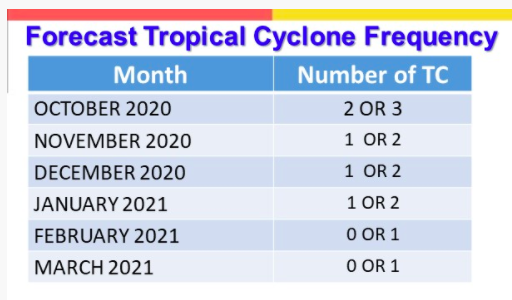 (source: PAGASA)
Preparing for Possible Outcomes
According to Dr. Renato U. Solidum, Jr., the undersecretary for Disaster Risk Reduction and Climate, various agencies should focus on Disaster Risk Reduction Management (DRRM). “First, we need to monitor the different weather and climate phenomena, which PAGASA is doing. Second is assessing hazards and risks, which involves identifying the risks, their effects and the affected areas. Third is disseminating information and warnings to different sectors through proper communication channels. And fourth—the most important of all—is to have an effective and efficient response.” This includes mitigation measures, their effectivity, and a quick response that will lead to quick recovery.
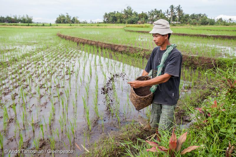
Impact on Agriculture
Solis stated that during La Niña, low-lying agricultural lands are prone to floods, which may produce extensive crop damage. Recurring rains also increase the possibility of pests and crop disease, and may lead to river flooding and dam spillage.
Impact on Health
During excessive rainfall, there is a prevalence of waterborne diseases such as cholera and leptospirosis in flooded areas—things we need to avoid, along with loss of lives from flashfloods.
Impact on Environment
Landslides and mudslides are possible, while coastal communities are warned against coastal erosions due to strong waves. In the urban setting, damage to infrastructures is possible, as well as urban flooding, economic losses, and increased traffic.
 Angat Dam located in Bulacan (file photo)
Filling our Dams
The water level in Angat Dam, which supplies 97% of Metro Manila’s water needs, has been slowly but continuously decreasing. “These past weeks, we’ve seen a decline in Angat, Pantabangan and other dams. Even if it rains in these areas, they don’t hit our reservoirs,” Dr. Malano reported. But because of the rainfall forecast during La Niña , our dams are expected to recover. Weather Services Chief Roy Badilla of PAGASA’s Hydrometeorology Division stressed this benefit of La Niña: “50% of our rainfall come from tropical cyclones and La Niña, so without the La Niña, our dams won’t have enough water.”
Solis encouraged the public to maximize rain water harvesting and storage to cope with the dry season from April to June. Flood warnings and advisories from PAGASA should also be monitored. To avoid floods, the Department of Public Works and Highways (DPWH) is requested to remove road obstructions. As local government units and disaster risk reduction offices prepare for imminent disasters, farmers need to strengthen their post-harvest facilities to ensure the proper drying and storage of their produce. “Adverse impacts are likely over the vulnerable areas and sectors of the country,” Solis added. “While our dams have their fill of rain, we should mitigate the possible impacts of La Niña and the amihan.”
La Niña and the Pandemic
Though La Niña is a natural climate variability, Solis said that climate change might also be affecting its pattern. “Before the year 2000, strong El Niño and La Niña episodes occur at least every 7 to 10 years. But during the past decades, the intervals have been cut down to 5 to 7 years. Along with their increased frequency is the increased intensity of their impacts.”
Because this year’s La Niña is coupled with the COVID-19 pandemic, PAGASA’s OIC-Deputy Administrator for Research and Development Esperanza Cayanan emphasized the need for preparedness in evacuation centers. “We need to enforce physical distancing among evacuees, and make sure that these centers are not used for COVID-19 patients.” Solis mentioned the same concern for hospitals. “Health care centers and hospitals should prepare for additional patients with water-borne diseases, and to separate them from COVID-19 patients.”
In the meantime, Dr. Malano suggested the use of schools and churches, now empty because of the prohibition of mass gatherings and face-to-face classes. “Disaster risk reduction should be everyone’s responsibility. We need to cooperate with each other so we can open up these facilities for evacuees, allowing them to observe physical distancing.”

New studies from the International Atomic Energy Agency (IAEA) researchers showed that climate change does not only affect the severity or amount of rain but also the precipitation patterns.
According to Al Gore, the founder of the Climate Reality Project, since warmer air holds more moisture, rising global temperatures also contribute to the changes in rain patterns, including rain’s occurrence, duration and distribution. Gore also stated that global water vapor increases by 7% for every degree centigrade of warming.
Climate change can affect two types of rain – stratiform and convective. Convective rain, which occurs more frequently, is sudden, intense and local. Meanwhile, the stratiform type is lighter and can fall over a larger area for a longer time.
Isotopes as clues
In June 2016, hydrology specialist Pradeep Aggarwal and his co-authors announced that the oxygen and hydrogen isotopes in rain samples provided data on the ratio of these two rain types.
Isotopes are atoms of the same element that have different numbers of neutrons that result to different atomic weights. The condensation and evaporation of water affect the ratio of heavy to light isotopes.

Observing and understanding how the water cycle responds to climate change is difficult and critical. These findings could also contribute to a better understanding of how climate change affects rainfall patterns, which could later help in adaptation and precipitation models in the future.
Rainfall and Climate Change
As temperatures rise, air becomes warmer. Hence, more moisture evaporates from land and water into the atmosphere. More moisture in the air means more precipitation and heavy downpour.
The problem is that extra rain is not evenly distributed throughout the globe. Because of the shifting air and ocean currents brought by climate change, some countries may receive more or less precipitation than others. According to the US Environmental Protection Agency (EPA), the world is already getting more rain and snow than it did a century ago.

Looming La Niña
PAGASA and other international meteorological agencies confirmed a 55 to 60% probability of La Niña development in the last quarter of 2016. La Niña is the unusual cooling of ocean temperatures in the Central and Eastern Equatorial Pacific.
Because of this weather phenomenon, more active rainfall activity is expected in Southeast Asia, including the Philippines. PAGASA said that after the sweltering dry months, we are now anticipating slightly cooler and wetter months ahead.
Rising temperatures triggered by climate change and the previous El Niño episode may begin to decelerate due to La Niña. According to the University of New South Wale’s Climate Change Research Center, a rise in global temperatures may still occur, but it won’t be as rapid as what had been observed last year.

Sources:
PAGASA
US Climate Prediction Center
International Atomic Energy Agency
University of New South Wale’s Climate Change Research Center
US Environmental Protection Agency
If you’re a pluviophile or a person who loves the rain, you probably jumped for joy when PAGASA officially announced the onset of the rainy season last May 24. It’s also enough reason for ceraunophiles (people who are fond of thunderstorms) to celebrate!
But for those not too fond of rains, they often complain how rains could ruin their well-thought-of plans, especially for the weekend. The question remains: does it actually rain more on weekends?

The verdict
According to PAGASA Weather Forecaster Mr. Gener Quitlong, the weather doesn’t depend on any specific day, but on the prevailing weather systems, such as the easterlies or a low pressure area.
Rains can also be influenced by an area’s state of urbanization. The more urbanized a place is, the more manmade pollutants it has, which may influence the weather.
“Cities impact rainfall and can create their own rain and storms,” Dr. Marshall Shepherd, an Associate Professor of Atmospheric Sciences and Geography at the University of Georgia in the U.S. explained.
But there may be some truth to the observation that it tends to rain more on weekends. Dr. Randall Cerveny of the Arizona State University, together with Geography Professor Robert Balling, examined rainfall in the Atlantic Ocean between 1979 and 1995 by analyzing global satellite data. Though the ocean tides were not affected by the day of the week, they found that the US was soaked during weekends. “Records from monitoring stations showed that levels of two urban pollutants, ozone and carbon monoxide, rose as the weekend approached,” Cerveny stated. On weekdays, human activities, such as daily commute and the use of heavy-duty office appliances are its peak, making the cities cesspools of pollution. This build up of pollutants may have taken effect by the time the weekend rolls around, giving rise to the possibility of rain.
But regardless if it’s the weekend or not, you know what to do this rainy season: bring umbrellas and raincoats, and most important of all, think of alternative and creative ways to enjoy your weekends in case it rains!
– By Angelyssa Lopez, PanahonTV intern

Picture this: dark skies, the rain falling on the roof in a gentle rhythm, your window panes peppered with raindrops sliding down the glass intermittently like comets streaking across the sky. Something about the whole thing makes you want to dig up those poignant memories, or tune in to sad, sappy songs on the radio. Some may call it a touch of melancholy, but experts have given this weather-driven mood swings a name: Seasonal Affective Disorder or SAD.
SAD is a depression disorder linked to the change in seasons, which women, who are naturally in touch with their emotions and prone to hormonal changes, are more likely suffer three times more than men. Though SAD is not limited to rainy weather, this disorder is only experienced by a minority during the summer.
According to psychologytoday.com, 10 million Americans are affected with SAD, with 10 – 20% experiencing its mild version, commonly felt by those below 20 years old when it rains.
Meanwhile, Dr. Concepcion Sy, a Clinical Psychologist, says it is rare for Filipinos to experience extreme SAD. Usually, Overseas Filipinos experience this disorder more frequently, especially during the Ber months. The cold weather, along with hormonal changes during menopause or menstrual-related events, may trigger emotions associated with emotional isolation and mild depression.
Here are some other common symptoms of SAD:
• Laziness
• Increase in appetite
• Preference to be left alone
• Lack of focus
When the emotions become too overwhelming, Dr. Sy recommends seeking psychological help. Its mild version, however, may be managed by socializing with friends, or for by being productive.
Even if the weather hinders you from leaving your home, you can still connect with loved ones through social media sites, and the telephone. Sometimes, a simple conversation or a simple task such as decluttering your room can go a long way in chasing those rainy day blues away.
Source:
http://www.webmd.com/depression/guide/seasonal-affective-disorder
https://www.psychologytoday.com/conditions/seasonal-affective-disorder
The National Disaster Risk Reduction and Management Council (NDRRMC) and PAGASA released a list of areas deemed critical as Typhoon Hagupit threatens the Philippines.
As the typhoon approaches, 44 provinces has been put under Alert Level C. These areas may experience 10 to 20 millimeters per hour of rainfall, which translates to heavy to intense rains, bringing heavy damage to agriculture, disruption of electrical power, and threat to travel.
Meanwhile, 6 provinces are expected to experience moderate to heavy rainfall at 5 to 10 millimeters per hour categorized under Alert Level B. Moderate damage to agriculture and risky travel are possible due to wind strength of 30 to 60 kilometers per hour, which is enough to uproot a few large trees and dislodge iron roofing.
Meanwhile, Metro Manila is put under Alert Level A, along with five more provinces. 5 to 10 millimeters per hour or moderate to heavy rainfall is expected with winds reaching up to 30 to 45 kilometers per hour.
Check the complete list below:

The cloud cluster spotted yesterday morning has developed into a low pressure area (LPA). It has already entered the Philippine Area of Responsibility (PAR) and was estimated at 880 kilometers east of Mindanao this 4:00 AM.
PAGASA Weather Forecaster Glaiza Escullar said the LPA has a slim chance of developing into a tropical cyclone. However, it is expected to move towards Eastern Visayas, traverse the areas of Visayas region until it reaches Palawan. The weather bureau continues to monitor the said weather disturbance.
Meanwhile, the easterlies characterized by warm and humid air coming from the Pacific, will bring partly cloudy to cloudy skies with isolated rain showers or thunderstorms mostly over the eastern section.
On the other hand, the northeast monsoon or amihan has slightly weakened. Coastal waters over Northern Luzon will be moderate to rough while the rest of the country will experience slight to moderate seas.

Special Non-working day in Maragusan
Pursuant to Proclamation No. 908, today was declared as a special non working day in Maragusan, Compostella Valley, This is to give the people an opportunity to participate with the activities in line with the Foundation Day Anniversary of the municipality.
They say that when it rains, it pours. The same logic seems to apply to the recent traffic situation here in the metro with sudden rains usually making their grand entrance in the evenings or late afternoons just before rush hour—the perfect recipe for clogged roads, as well as irate commuters and motorists.
But the real question is: why are rains synonymous with heavy traffic? We interviewed the metro traffic experts, also known as the Metropolitan Manila Development Authority (MMDA) to shed some light on this phenomenon.
Flooding along the streets make them impassable. Blame it on poor waste management, overpopulation, or faulty urban planning, but the fact cannot be denied; we’ve all witnessed, first-hand, how the streets of Manila get easily flooded when there’s a rapid downpour. According to PAGASA, these light to moderate, and occasionally, heavy rains that may persist for two hours, can already trigger flooding especially in low-lying areas like Caloocan, Malabon, Navotas and Valenzuela.
Road conditions deteriorate with the flow of rainwater. When the rains are pelting down like there’s no tomorrow, driving conditions are at their worst. Instead of cruising down the highway (within speed limits, of course) drivers are more cautious, navigating their vehicles more slowly. Road visibility is also compromised, as well as the driver’s usual routes. Because some of these may be flooded, alternate routes are taken, which eventually become clogged because everyone else has the same idea.
Rains tend to increase the possibility of road accidents. It’s only right that motorists take extra caution because based on MMDA’s data, are on the rise when the rains come. From January to June 2014, a total of 12 non-fatal road accidents and 137 damages to properties were recorded. These accidents take up road space—and we all know how just one blocked lane can create chaos hundreds of kilometers down the road. Reserve those daredevil maneuvers on the racetrack. Safety first when you’re driving, especially when it’s raining.
Motorcycle drivers make pit stops to wait out the rain. Because of the flooded areas, light vehicles, including motorcycles, don’t dare cross the flood and tend to halt in one area of the road. A lot of them also take cover from the rain under the overpass. When these motorcycles increase in number, they take up road space and cause traffic.
Despite this grim scenario, we are not totally helpless against rains and the inevitable heavy traffic they bring. Don’t let thunderstorms surprise you by monitoring weather updates. Plan your alternative routes early, and if possible, build your travel schedule around those downpour-prone afternoons and evenings so you won’t get caught on the road, in the rain!

SOURCES: PAGASA | MMDA
This rainy season, eat your way to better health! Learn how you can boost your immune system in five delicious ways.

Photo Credit: https://www.flickr.com/photos/mattmendoza/4069052407
The rainy season, also known as the cough-and-colds season, is a challenge for people of all ages, health-wise. Though there are no conclusive studies that prove that the weather itself lowers our resistance to viruses and bacteria, some scientists believe that the cold weather encourages people to stay indoors. In this close proximity with other human beings, sicknesses become easily transmittable.
To protect yourselves, you need to have a healthy lifestyle, which includes eating, not only food that’s fresh and safe, but also the right kinds of food. Here are five foods to help you fight those nasty diseases.
1. Chicken Soup
It’s not only good for the soul, but also for your health. Aside from the obvious fact that a bowl of hot soup can warm you up, chicken, while being cooked, releases a type of amino acid that chemically resembles a bronchitis drug called acetylcysteine. If you’re craving a heavier version, whip up a pot of arroz caldo that doesn’t only give you your fill of carbs, but also ginger, believed to break down toxins in the lungs and sinuses to help you breathe easier, and onions and garlic—both natural antiseptics and immunity boosters.
2. Vitamin C-Rich Munchies
Vitamin C, which reduces cold symptoms by 23%, can be found in abundance in local citrus fruits such as calamansi and dalandan. You’d be surprised that other foods such as red bell pepper, papaya, tomatoes and broccoli also have high amounts of this antioxidant!
3. Fish and Shellfish
We’re lucky to be surrounded by the ocean so we have our bounty of seafood. Shellfish such as clams, oysters and crabs aids white blood cells in producing a kind of protein that help rid the body of flu viruses. (Just watch out for red tide season!) Meanwhile, omega-3 fats reduce inflammation, protecting lungs from respiratory infections. For your omega-3 fix, stock up on tuna, tanigue, tulingan, tawilis and dilis.
4. Probiotics
Probiotics are the good bacteria that make sure that your intestinal tract remains healthy and free from disease-causing germs. You can get these from yogurt and other food products. Just check the labels to see if they contain probiotics, particularly the bacteria called Lactobacillus reuteri, which block the multiplication of viruses that attack the body.
5. Water
People aren’t kidding when they say that water is life. Water is a cure-all for all sorts of sicknesses. It keeps your body hydrated, giving you the boost to fight those viruses. It also gives you an internal cleansing, washing away the toxins, released through waste products. Drink as much water as you can everyday—go beyond the required eight glasses!
There you have it—5 super foods to help you get through the rainy season. But before you dig in, remember to wash your hands thoroughly with soap and water. This prevents another disease common during the rains—the dreaded diarrhea!
Sources:
http://www.prevention.com/food/healthy-eating-tips/power-foods-boost-immunity
http://www.health.harvard.edu/flu-resource-center/how-to-boost-your-immune-system.htm
http://www.doctoroz.com/slideshow/boost-your-immunity-naturally
http://www.nbcnews.com/id/37856647/ns/health-diet_and_nutrition/t/eat-killer-immunity/