Each generation has its share of mind-blowing disasters. For our generation, one of the worst devastations ever to hit our country was caused by Typhoon Yolanda. Today, we remember the wrath of this ferocious typhoon that greatly affected the Visayas area exactly three years ago.
Based on the climatological records of PAGASA, tropical cyclones that enter the Philippine Area of Responsibility (PAR) during the month of November have a higher chance of hitting the landmass. Proof of this wasYolanda, which originated from the Pacific Ocean, gaining much strength as it headed towards the Philippines.
With the international name Haiyan, Yolanda became one of the world’s most disastrous typhoons, packing winds of up to 235 kilometers per hour and with a gustiness reaching 270 kilometers per hour.
Within a day, six landfall activities were recorded by the Philippine Atmospheric Geophysical and Astronomical Services Administration (PAGASA). On November 8, 2013, Yolanda hit the following areas:
– Guiuan, Eastern Samar
– Tolosa, Leyte
– Daanbantayan, Cebu
– Bantayan Island, Cebu
– Concepcion, IloIlo
– Busuanga, Palawan
Yolanda exited the PAR on November 9, 2013, leaving a horrific view of Leyte and Samar. Aside from flash floods and landslides, the intense winds of the typhoon triggered storm surges that devoured Leyte, particularly the city of Tacloban. Many Taclobanons said it was like the entire sea had crawled over the land.
At least 6,000 people were reported dead while more than a thousand are still missing. Thousands of families were affected in Regions IV, V, VI, VII, VIII, X, XI and CARAGA. The combined power of water and winds smashed almost 1.2 million houses.
“Super Typhoon”
Days before the first anniversary of Yolanda in 2014, the Typhoon Committee of PAGASA decided to revise the classification of tropical cyclones, adding the category “Super Typhoon” to the list.
PAGASA explained that the revision aims to emphasize the intensity of a tropical cyclone and the threat of its impacts. Using the term “Super Typhoon” will also escalate the sense of urgency and community response in times of an approaching storm.
In October this year, “Lawin” became the first tropical cyclone to be classified as a super typhoon— the first time that PAGASA issued Signal Number 5 as well.
Dissecting Typhoons
Being one of the most vulnerable countries to extreme weather events, we are also in the frontline when it comes to destructive typhoons. To understand this natural hazard, let us familiarize ourselves with the different parts of a typhoon.
Eye
The eye of a typhoon is an area with the lowest air pressure, which can be as much as 15% lower than the pressure outside it. It may vary in shape, which can sometimes be a circle, an ellipse or oval. Its diameter also changes in time, but usually shrinks as a typhoon intensifies.
While many people think the eye is the deadliest part of a typhoon, it is the calmest. In strong tropical cyclones, this area is characterized by light winds and clear skies. For weaker cyclones, the eye is less defined and is usually covered by dense, high and thick clouds.
The eye or the center is helpful for weather forecasters and meteorologists because it serves as the reference point in plotting the typhoon’s location. The formation of an eye is also used as an indicator of the increasing strength of a tropical cyclone.

Eye wall
Surrounding the eye is the eye wall, where the severe weather occurs. It is the innermost ring of convection near the center of the typhoon, packing the fiercest rains and most intense winds.
The National Oceanic and Atmospheric Administration (NOAA) says this is the zone where surface winds reach their highest speed, bringing the strongest thunderstorm activity.
According to the State Climate Office of North Carolina, the contraction or expansion of the eye wall can cause changes in wind speed and storm strength. As a typhoon grows and changes, it can build concentric eye walls that replace the original eye wall.
Eye Wall Replacement
While most typhoons have a single eye wall, powerful and mature typhoons acquire double eye wall structures. Typhoons with double eye walls often undergo a process called “eye wall replacement cycle”. This occurs when a new eye wall develops and replaces an existing one.
According to the Hong Kong Observatory, this cycle begins with a concentrated ring of convection that develops outside the eye wall. It will then circulate inward, leading to a double-eye wall structure. The inner eye wall dissipates while the other intensifies and moves inward.

Spiral Rain Bands
Spiral rain bands are found outside the eye wall. NOAA defines rain bands as long, arching bands of clouds and thunderstorms that spiral out of the eye wall. Dense bursts of rain and winds are often associated with these bands. Also referred to as “buntot ng bagyo”, rain bands form the outermost fringes of the typhoon structure.
Sources:
PAGASA
NOAA
NCSU
Hong Kong Observatory
American Meteorological Society
World Meteorological Organization
Recovery is still taking place in Yolanda-battered areas, and is expected to be completed in 2017. But how far have we really gone three years after the catastrophe?
Hope Shines in Yolanda-Hit Areas
By George Vincent Gamayo
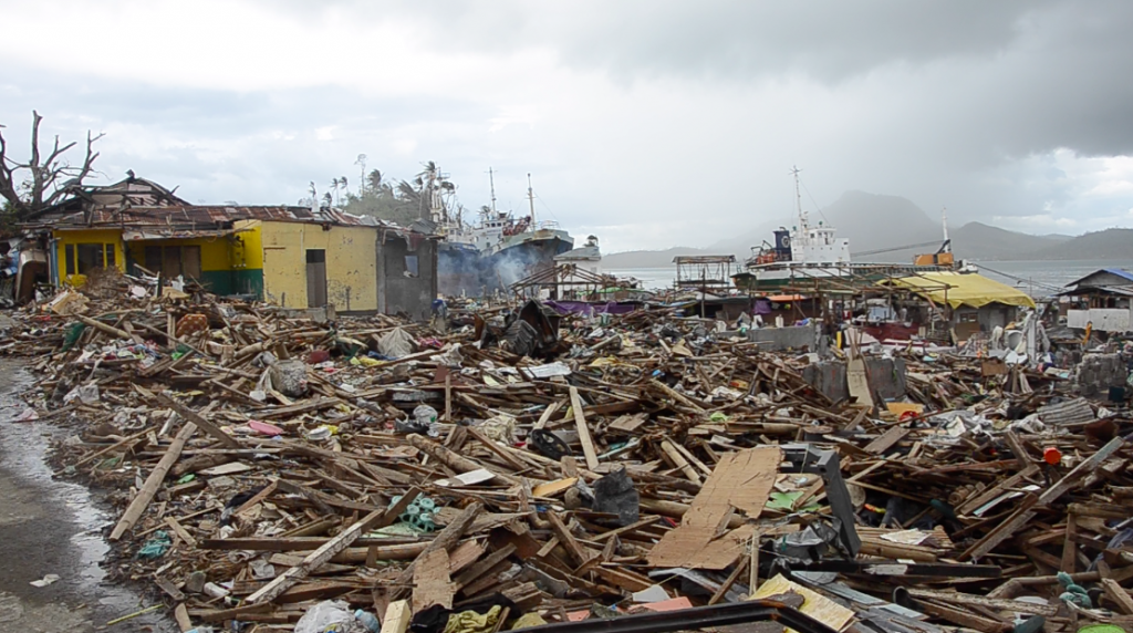
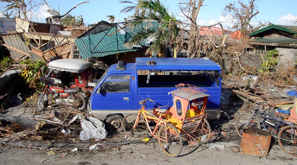
AFTERMATH OF STORM SURGES. No less than 10 ships were swept off the sea, smashing into Leyte’s coastal communities during the onslaught of Typhoon Yolanda.
It’s been three years since Typhoon Yolanda (Haiyan) struck Visayas and Palawan on November 2013, devastating 6,300 lives, displacing more than four million residents, and affecting 14 million people.
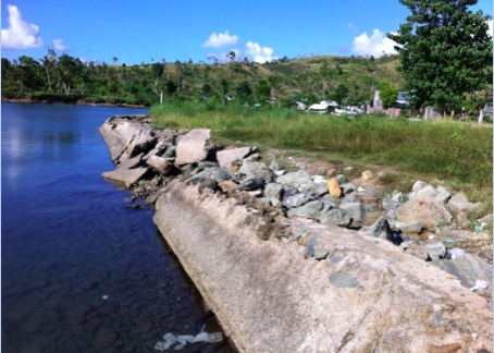
The broken seawall in Marabut, a 5th class municipality in Western Samar, prone to storm surges and vulnerable to sea level rise.
Yolanda, considered one of the strongest typhoons in the world in the past century, first made landfall in Samar, wiping out its substandard seawall in Barangay Pinalanga in Marabut. In 2015, the seawall was rehabilitated under the initiative of the Department of Social Welfare and Development (DSWD), through its program Kapit Bisig Laban sa Kahirapan Comprehensive and Integrated Delivery Social Services (Kalahi-CIDSS) by empowering the coastal community to rebuild the structure.
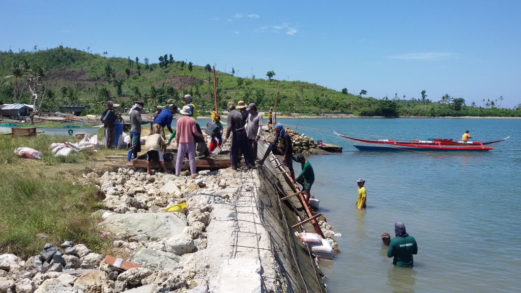
REBUILDING THE SEAWALL.
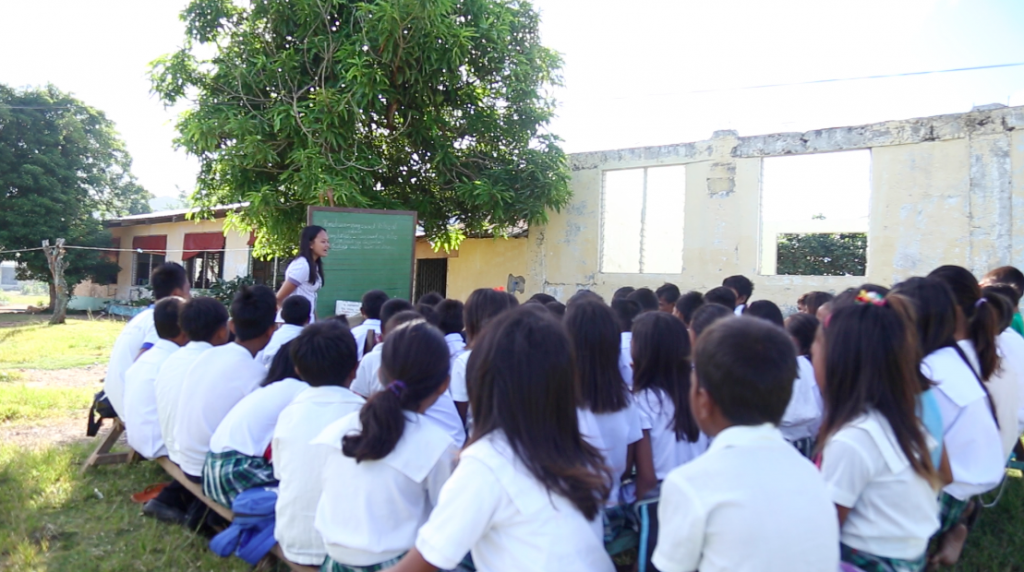
Classrooms at the Lantangan Elementary School in Iloilo were washed out by the typhoon.
After the calamity, teachers in Gigantes Island conducted classes under the shade of trees. But early this year, damaged rooms were rehabilitated and new schoolrooms were built.
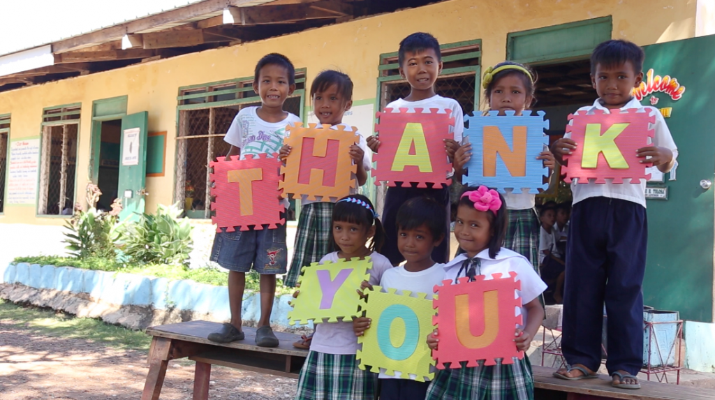
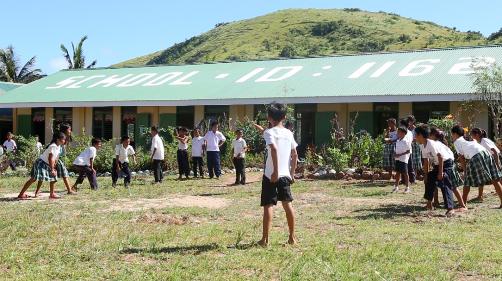
As of September this year, the government was able to construct 1,316 new classrooms in areas affected by Yolanda. But over 10,000 schoolrooms still need rehabilitation.
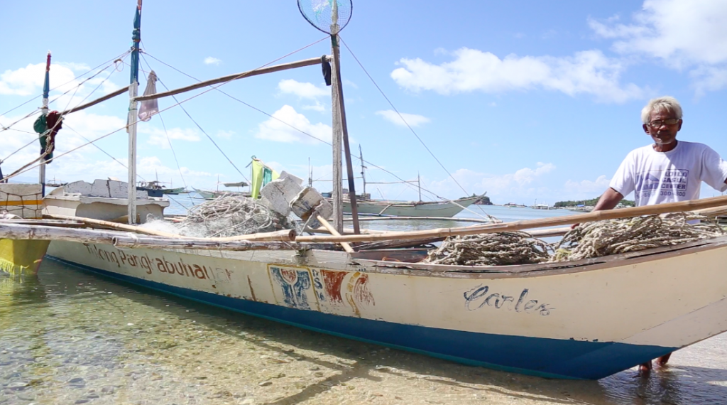
Nearly 50,000 boats were either replaced or repaired by the government. One of the beneficiaries is Billy Bolohabo of Lantangan in Carles, Iloilo. ”They provided us boats, nets and other fishing equipment,” he said. “They even gave out cash support to help us. All of us are very thankful for the opportunity to start again.”
Typhoon Yolanda wrecked 1,140,332 houses— 550,928 from these were totally damaged. The National Housing Authority (NHA) targeted 205,128 housing units but as of June 2016, only 2,287 were distributed from the 25,967 accomplished units.
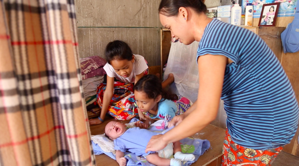
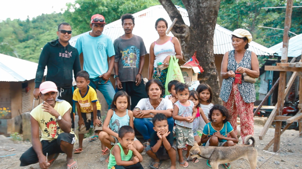
Ivy Dacuno is one of the recipients of a permanent house from the government a year after the tragedy. She used to live in Barangay 88 in San Jose, Tacloban City, one of the worst-hit areas due to the ravage of storm surges that killed one of her children. Apart from the shelter assistance, the DSWD provided her with a 15-day skills and livelihood training. “Tinuruan kami magluto ng mga pagkaing pwede naming ibenta. Binigyan din kami sa training ng P12,000 para makapagsimula ng sarili naming business,” Ivy explained. (We learned how to cook food that we can sell. They also gave us P15,000 so we can start our own small business.”) She now sells food in their relocation site in Barangay 97, Cabalawan, Tacloban City.
Ivy starts her day by feeding her children, and cooking porridge to sell in the neighborhood.
With the DSWD’s Emergency Shelter Assistance (ESA) program, P20.73 billion were distributed among those who were left homeless. As of mid-August this year, 468,528 beneficiaries with totally damaged houses received P30,000 each, while P10,000 were given to those with partially damaged abodes.
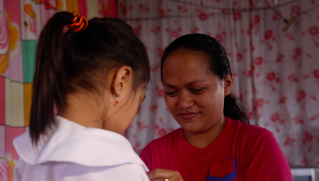 Rosemarie with her daughter, a 4th grade student
Rosemarie Arponbiong, 35, survived the height of the crisis by joining food for work programs. 5 kilos of rice were given to them for fifteen days in exchange for clearing off debris caused by the typhoon. A year after the catastrophe, she received P30,000 from the DSWD, and was able to build a new home for her family— this time, a concrete one.
“Kapag malakas ang ulan, nakikinig na lang ako sa radyo para malaman kung posibleng tumaas ang tubig. Kung sa hangin lang naman, kayang kaya na ng bago naming bahay,” Rosemarie enthuses. (I listen to the radio whenever there are heavy rains to watch out for possible floods. But I’m happy that our new house can withstand strong gusts of winds.)
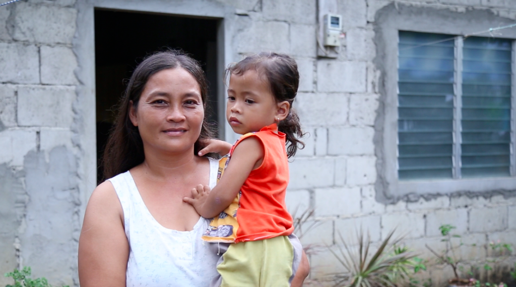 Eda carrying her youngest child who was born days before the wrath of Yolanda
Eda Dumape, a mother of five in San Remegio in Cebu, will never forget the longest two hours of her life during the onslaught of Yolanda. “Pait kaayo ang kaagi nko sa bagyong Yolanda kay bag-o pakong nanganak nya kay kanag nangaguba pa ang among atop sa balay nyang mga bata namo lisud kaayo kay bag-o pa kong nanganak. Nag-agas-agas akong dugo. Gitakluban nalang ko sa akong bana ug habol kay para di ko maka kita sa tanan nga nanghitabo, kay ang dili ko ma kuwan sa maong bagyo. Pag-human sa maong hangin, pag menor na siya. nibalhin mi didto sa among silingan nga kasaligan sad siya, dayon, mao pud pag kusog utro sa hangin, giuyog pud ang maong among gibalhinan sa pikas balay,” Eda reminisces. (My experience during Typhoon Yolanda was the most difficult because I just gave birth to my youngest. I was bleeding at that time. Because our roof was ruined, my husband covered me with a blanket so I wouldn’t see what was happening. We immediately evacuated and transferred to our neighbor when the winds calmed. But the strong winds reoccurred, and our neighbor’s house started shaking.) Eda received a P10,000 grant from ESA, which she used in rehabilitating their house.
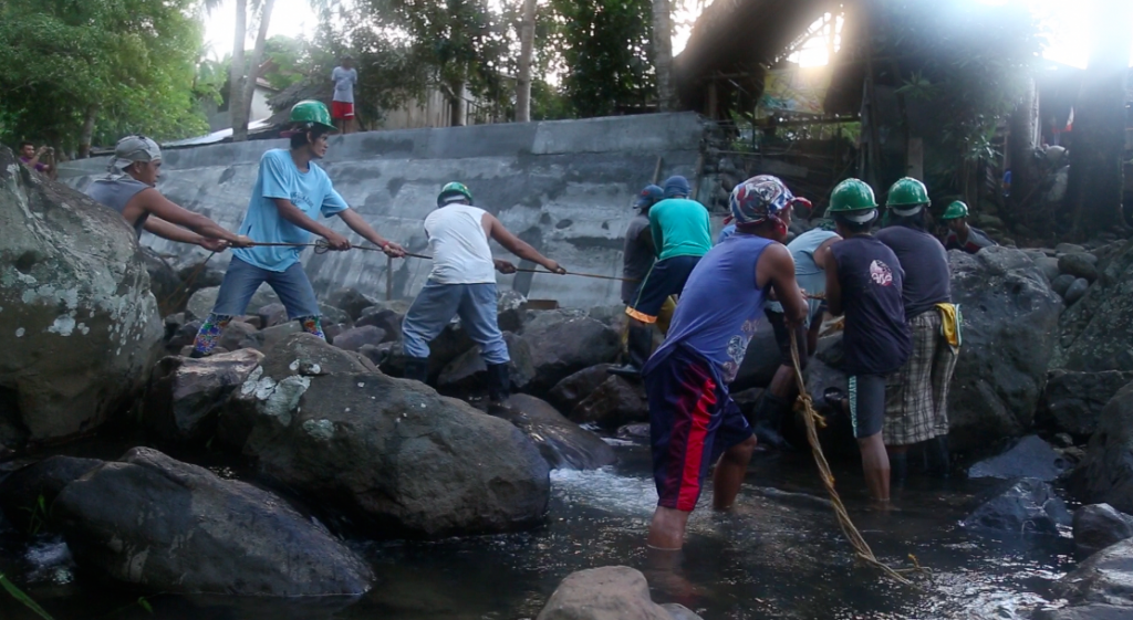 People in Abuyog, Leyte building their flood control system. As of the first quarter of 2016, more than 90 flood control structures were constructed to protect Yolanda survivors from hydrological hazards.
The indigenous people in Sitio Nagpana in Barotac Viejo, Iloilo were given a multi-purpose hall, which they can use as evacuation site during inclement weather.
Yolanda may have devastated lives and property, but still, it did not break the spirit of survivors. With the lessons they had learned, people were able to get back on their feet. In the midst of massive destruction, there will always be room for hope, camaraderie and resilience.
In meteorology, the life cycle of a tropical cyclone starts with cloud clusters that develop into a low pressure area (LPA). Once this LPA intensifies, it becomes a tropical cyclone, the general term for “bagyo.” This tropical cyclone is then classified based on its wind speeds.
Through the years, the Philippine Atmospheric Geophysical and Astronomical Services Administration (PAGASA) has used three official tropical cyclone categories: Tropical Depression, Tropical Storm and Typhoon.
Yolanda, with the international name Haiyan, which made its landfall in the country last November 2013, is remembered as one of the strongest typhoons in recent years. Largely affected was the Visayas area, where storm surges caused massive destruction to lives and properties.
Days before the first anniversary of Yolanda, the Typhoon Committee of PAGASA decided to revise the classification of tropical cyclones, adding the category “Super Typhoon” on its list. However, this memo said that the revision will be applied in 2015.
In May 2015, by virtue of Memorandum Circular No.3, PAGASA officially declared that Super Typhoon is now part of the tropical cyclone classification.

The new tropical cyclone classifications are as follows:
Tropical Depression (TD) has maximum sustained winds of up to 61 kilometers per hour, equivalent to 33 nautical miles per hour or more.
Tropical Storm (TS) packs 62 to 117 kilometers per hour. Meanwhile, a Severe Tropical Storm will only be applicable for the International Warning for Shipping, and will not be used for general public dissemination unlike the other categories.
Typhoon (TY) is used in identifying a tropical cyclone with wind speeds 118 to 220 kilometers per hour or 64 to 120 knots.
Super Typhoon (STY) has maximum sustained winds of more than 220 kilometers per hour. STY is as powerful as 120 nautical miles per hour or more.
Since there are changes in cyclone categories, the public storm warning signals (PSWS) were revised as well. According to PAGASA, the country has experienced a number of destructive tropical cyclones in the past ten years. These cyclones were mostly in Typhoon category with maximum sustained winds of more than 220 kilometers per hour. During the passage of Yolanda, the usual four-level warning system of the PSWS was found inadequate.
In line with this, Signal Number 5 now becomes part of PAGASA’s warning.

Once PSWS #5 is hoisted, residents must prepare for winds of more than 220 kilometers per hour in at least 12 hours. This can cause very heavy to widespread damage to the affected areas.
PAGASA explained that the revision aims to emphasize the intensity of a tropical cyclone and the threat of its impacts. Using the term “Super Typhoon” and “Signal Number 5” will also escalate the sense of urgency and community response in times of an approaching storm.

The Ridge of High Pressure Area continues to affect Luzon. This weather system is associated with fair weather conditions and high temperatures.
Today, the Philippines will experience partly cloudy to cloudy skies with isolated rain showers or thunderstorms mostly in the afternoon or evening.
Temperatures may reach up to 35 degrees Celsius with the heat index forecast showing 40.2 degrees Celsius in Metro Manila.

To counter the heat while looking your best, wearing light-weight and light colored clothing is recommended. Sunglasses don’t only look trendy; they also protect your eyes from the glare. Umbrellas with bright colors help shade you from the sun’s rays while giving off happy summer vibes.
In other news, PAGASA releases the revised classification of tropical cyclones effective May 01, 2015.
Accordingly, the public storm warning signal system of the agency was also modified.

Cyclone Pam raged in the South Pacific island nation, Vanuatu. The category 5 cyclone has been compared to Super Typhoon Yolanda (Haiyan) that devastated Central Philippines back in November 2013.
BBC News Asia reported that up to 90% of infrastructure were drastically shattered in the Pacific Island’s state capital Port Vila. The situation in the area was described into one word, “apocalyptic”, Red Cross Spokesperson said.

With winds of up to 165 mph, Pam swerved off from its forecast track damaging populated areas on Friday night. Like what happened during the nightmare of Yolanda, communities were wiped out.
For better comparison, let us go into the details of Pam’s and Yolanda’s (Haiyan) similarities.


Point #1: Winds
The Joint Typhoon Warning Center (JTWC) has recorded windspeeds 190 miles per hour for Super Typhoon Yolanda (Haiyan) during its landfall. Cyclone Pam was reported to have moved at 165 mph as it battered Central and Southern Vanuatu.
Point #2: Pressure
According to JTWC, Super Typhoon Yolanda (Haiyan) has a reported central pressure of 895 millibars upon making its landfall on November 7, 2013. Meanwhile, Cyclone Pam is at 899 millibars as of 11 PM on March 13 as reported by the Fiji Meteorological Service.
Specifics shows slight differences between Cyclone Pam and Super Typhoon Yolanda (Haiyan). However, the disparity were of no value considering the annihilation they both brought.
Ruby continues to weaken as it traverses the landmass of Southern Luzon. With maximum sustained winds of 60 kph, Ruby is now downgraded to Tropical Depression, the lowest category of Tropical Cyclones.
PAGASA Weather Forecaster Glaiza Escullar said the weakeaning of Ruby is due to the friction between the landmass and the weather disturbance, and the intrusion of the northeast monsoon or amihan–cold and dry air mass that is not favorable to cyclone intensification.
Tropical Depression Ruby made its fifth landfall over Lubang Island at 5 AM today. Its first landfall was in Dolores, Eastern Samar last Saturday at past 9 PM. Its second landfall was in Cataingan, Masbate last Sunday morning. The third was in Torrijos, Masbate yesterday at 11:05 in the morning. Its fourth landfall was in Laiya, Batangas yesterday at 5:45 PM.

At 4 AM today, Ruby was located at 80 kilometers southwest of Ambulong, Tanuan City in Batangas, moving westward at 13 kph. (FOR REVISIONS PAG MAY LATEST LOCATION)
Escullar confirmed that if Ruby maintains its velocity, it is expected to exit the Philippine Area of Responsibility on Wednesday.
Public Storm Warning Signal

Areas included under Public Storm Warning Signal no. 1 will experience occasional rains with gusty winds.
Meanwhile, Public Storm Warning Signals elsewhere have been lifted.
Tuesday rainy weather
Apart from those under Public Storm Warning Signal no. 1, the rest of Central Luzon, Bicol Region and MIMAROPA will have cloudy skies with light to moderate rains and thunderstorms.
Because the amihan is now affecting Northern Luzon. cold weather and light rains are expected over Cagayan Valley, the Cordillera and Ilocos Regions.
Rainfall Data as Ruby crawl along PH islands.
Here is a list of areas that accumulated the highest rainfall during the passage of Ruby.


Typhoon Haiyan,last year locally named Yolanda, which wreaked havoc in Eastern Visayas last year, remains to be the strongest typhoon, bearing maximum sustained winds of 235 kph. However, Typhoon Ruby now holds the title of being the longest-staying typhoon inside the Philippine Area of Responsibility (PAR) this year.
State Weather Forecaster Meno Mendoza says Ruby beats the 5-day record of Typhoon Henry back in July this year. Today is Ruby’s fifth day in PAR, and is now expected to exit our area of responsibility on Thursday morning instead of the earlier forecasted Tuesday.
The said typhoon further weakens as it continues to cross the archipelago, packing winds of 120 kph near the center and gustiness of up to 150 kph. It is now traversing the Sibuyan Sea at a speed of 10 kph moving in a west northwest direction.
After hitting Dolores, Eastern Samar late Saturday and Masbate yesterday morning, Ruby is expected to make landfall in northern Mindoro tonight, between 6 to 8 in the evening. Residents living in the said province are advised against moderate to heavy rainfall, strong winds and possible storm surge generated by the typhoon.
Public Storm Warning Signals as of this morning:

Areas under Signals Number two and three will experience stormy weather. Occurrence of a storm surge 1 to 2 meters high is possible in the coastal areas.
The remaining areas of Luzon and Visayas not included in the warning signals can expect rainy weather. Mindanao will experience improved weather conditions although thunderstorm formation is still possible in the following hours.
Metro Manila, on the other hand, can expect to feel the effects of the typhoon once it makes landfall in Northern Mindoro tonight. Residents can expect moderate to occasional heavy rains as it is the closest distance the typhoon will be from the metro.
Meanwhile, Malacanang announces the suspension of work in government agencies in the National Capital Region and in Southern Luzon today. Offices whose work involves the delivery of health services and disaster response are exempted.
Typhoon Ruby is expected to make its landfall over Dolores, Eastern Samar tonight between 8-10 PM. Residents in said areas are advised against strong winds, heavy to intense rainfall and storm surges up to 4.5 meters in height.
PAGASA Weather Forecaster Chris Perez says that if Ruby continues to move westward at 10 kph, after crossing Samar Provinces it would traverse the landmass of Ticao Island, Masbate and Romblon within 48 hours.
The Ridge of High Pressure Area influenced the movement of Typhoon Ruby, allowing it to dump more rains over the Visayas areas and portions of Southern Luzon and Northern Mindanao.
As of 1 PM today, Ruby was located at 230 kilometers East of Catarman, Northern Samar with maximum sustained winds of 185 kph near the center and gustiness of up to 220 kph.
Public Storm Warning Signal
Public Storm Warning Signals (PSWS) are being raised as Typhoon Ruby moves in closer to the landmass.

Threat of Storm Surge
Perez explained that coastal areas under Signals no. 3 and 2 are more prone to the possibility of storm surges.
However, the 4.5-meter wave height is not expected in all coastal areas. Perez says the height of storm surge depends on the coastal bathymetry, or as National Oceanic and Atmospheric Administration (NOAA) refers to “ocean’s depths that is relative to sea level or the depths and shape of underwater terrains.”
High storm surges are most likely to happen in coastal areas with shallow bathymetry.
Full moon and Storm Surge= STORM TIDE
Tonight, the moon will be on its Full Moon phase when the Moon, Earth and Sun are in near alignment. During this phase, the Moon is at the opposite side of the Earth, its entire illuminated part facing us.
The Full moon has a strong gravitational pull that can affect tidal variations. Because of the Full Moon, Perez says there is a possible occurrence of “storm tide,” which can generate higher waves than storm surges. Storm tide happens with the combined effect of the Full Moon and a storm surge.
Natural disasters, particularly typhoons, have earned special attention and mention throughout our nation’s history because of the devastation they leave behind, causing immense losses to infrastructure, agriculture and human lives.
This year alone, several typhoons have left their mark on the public consciousness, including Tropical Storm Fung-Wong (local name: Mario), which caused severe flooding in Greater Luzon, including Metro Manila, affecting more than 118 thousand families.

Photo credit: National Aeronautics and Space Administration (NASA)
Meanwhile, Typhoon Rammasun (local name:Glenda) crossed Southern Luzon in July with maximum winds of 150 kilometers per hour. It made its landfall in Albay, claiming more than one billion pesos worth of infrastructure and more than six billion pesos worth of agricultural products and facilities.

Photo credit: National Aeronautics and Space Administration (NASA)
Luckily in October, when Super Typhoon Vongfong (local name: Ompong), tagged as the strongest typhoon that entered Philippine Area of Responsibility this year, packing maximum sustained winds of 215 kilometers per hour, it kept its distance from the country as it moved outside our boundary. Though Vongfong did not do damage to the Philippines, Japan was not able to evade the rage of the super typhoon. 31 people were injured, 90,000 households in Okinawa had to evacuate, and more than 400 flights were cancelled. It also knocked out power supply in Okinawa.

Photo credit: National Aeronautics and Space Administration (NASA)
It seems that the names of the tropical cyclones are as unique as their characteristics and effects on the areas they have gone through. In the Philippines, PAGASA has a ready list of Filipino names for tropical cyclones.
Just as local names are important for easy communication among PAGASA, the media and the public, so are international names since these weather disturbances can affect more than one country. Through constant correspondence with other nations, we can gauge the cyclone’s track and projected effects—an important tool in increasing preparedness on both national and community levels.
How the naming process began
The areas where tropical cyclones are formed are divided into seven basins: North Atlantic Ocean, Northeastern and Northwestern Pacific Ocean (where the Philippines is located), Southwestern and Southeastern Indian Ocean, North Indian Ocean and Southwest Pacific Ocean.

According to the National Oceanic and Atmospheric Administration, Australian forecaster Clement Wragge introduced the use of proper names in naming cyclones in the late 19th century. When the Australian national government failed to establish the federal weather bureau and appoint Wragge as director, the forecaster took matters in his own hands and started naming cyclones after political figures whom he disliked and described as “causing great distress and wandering aimlessly about the Pacific.”
It took 40 years before the idea inspired George Stewart, a junior meteorologist in the United States to name Pacific tropical storms after his former girlfriends in his 1941 novel “Storm.”
It was in 1945 when the US armed services formally embraced the practice of using women’s names for typhoons in the Western Pacific. Eight years later, the US Weather Bureau finally adopted the use of women’s names for cyclones in the Northwest Pacific basin. It was in 1979 when men’s names were used.
Meanwhile, cyclones in the Southwest Indian Ocean started using names during the 1960s, while the North Indian Ocean cyclones were formally named in 2006.
According to the Weather Philippines Foundation, a new list of Asian names was contributed by all member nations of the World Meteorological Organization‘s (WMO) Typhoon Committee in January 1, 2000. These names are allocated to developing tropical storms by the Tokyo Typhoon Center of the Japan Meteorological Agency, and are arranged in alphabetical order of contributing countries. The majority of names includes flowers, animals, birds, trees, food and adjectives.
Currently, the Economic and Social Commission for Asia and the Pacific Typhoon Committee (ESCAP/WMO), which promotes the order and implementation of procedures required for minimizing the losses caused by typhoons, has 14 members: Cambodia; China; Democratic People’s Republic of Korea; Hong Kong, China; Japan; Lao People’s Democratic Republic; Macao, China; Malaysia; Philippines; Singapore; Thailand; Socialist Republic of Vietnam, and the United States of America.
Regardless of the year, international names are used per column. Below are the lists of names for developing tropical cyclones in the Northwest Pacific basin within a six-year time frame.


Retiring of Names
Tropical cyclone names are retired if they have caused significant damage and casualties in an area. A new list of names is discussed during the annual meeting of the WMO’s regional committee.
Sources: Weather Philippines Foundation | PAGASA | JMA | ESCAP/WMO | NOAA | NASA | Official Gazette of the Philippines | Japan NHK