The Intertropical Convergence Zone (ITCZ) has oscillated and is now affecting Southern Luzon and Visayas.
ITCZ is characterized as an area where winds coming from the Northern and Southern Hemispheres meet; this interaction results to rains in the affected areas.
As this weather system prevails, Metro Manila, Bicol Region, CALABARZON, MIMAROPA, Aurora and Visayas will experience cloudy skies with scattered rain showers and thunderstorms. Elsewhere, partly cloudy to cloudy skies prevail only with chances of localized thunderstorms.
The Intertropical Convergence Zone (ITCZ) is affecting Eastern Visayas and Mindanao.
ITCZ is characterized as an area where winds coming from the Northern and Southern Hemispheres meet; this interaction results to rains in the affected areas.
As this weather system prevails, cloudy skies with scattered rain showers and thunderstorms will be experienced in Eastern Visayas, Caraga and Zamboanga Peninsula. In the rest of the country including Metro Manila, partly cloudy to cloudy skies will prevail only with isolated rain showers or thunderstorms.
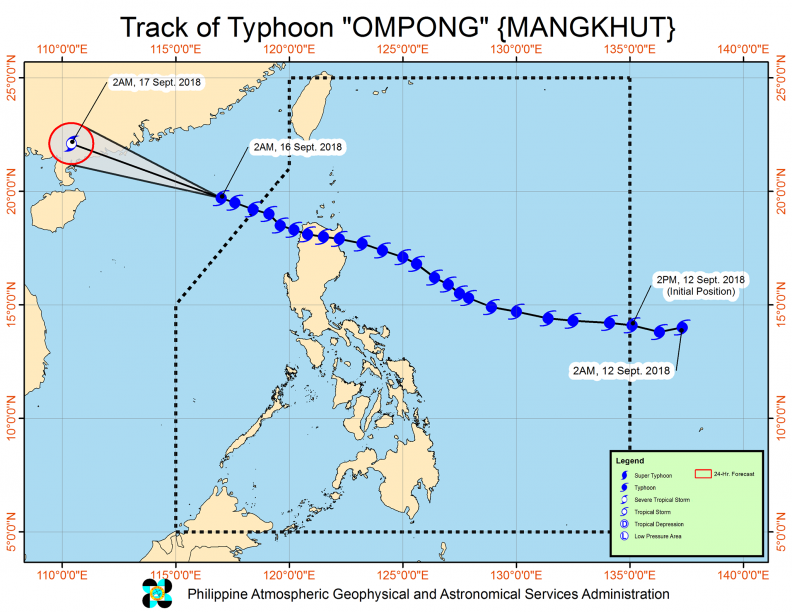
Typhoon Ompong (international name: Mangkhut) may now be outside the Philippine Area of Responsibility (PAR), but the Southwest Monsoon still affects the country, bringing cloudy skies with scattered to widespread rains and thunderstorms in Metro Manila, the rest of Luzon and Western Visayas. Partly cloudy to cloudy skies with isolated rain showers are expected in the rest of the country.
According to PAGASA Weather Forecaster Gener Quitlong, the country will enjoy good weather conditions within the next 2 to 3 days due to the absence of weather disturbances.
Although outside PAR, Mangkhut still brings rough to very rough sea conditions in the northern seaboards of Northern Luzon and the western seaboards of Central and Southern Luzon.
Sweltering days are here as two weather systems begin to prevail.
According to PAGASA, an extension or ridge of a High Pressure Area extends over Northern Luzon, while Easterlies remain dominant in the rest of the country. Today, the whole of Luzon, Visayas and Mindanao will experience generally fair and humid weather except for chances of localized thunderstorms in the afternoon or evening.
The country may be experiencing rising temperatures, but according to PAGASA, the Hot and Dry Season is yet to be officially declared. For this to happen, all of the following indicators should be present: the elimination of the Northeast Monsoon, the presence of High Pressure Area and Easterlies, and increasing temperatures.
Today, air temperature in Metro Manila can soar up to 33 degrees Celsius while residents of Tuguegarao can expect a scorching 35 degrees Celsius.
Rains, induced by three weather systems, will make flash floods and landslides possible in some parts of the country.
At 3:00 a.m., the Low Pressure Area (LPA) was estimated at 265 kilometers southwest of Puerto Princesa City, Palawan. As the Tail-end of a Cold Front dampens the eastern sections of Southern Luzon and Visayas, the Northeast Monsoon brings rains in portions of Northern Luzon.
In the next hours, Bicol Region, Quezon, Palawan, Eastern Visayas and Zamboanga Peninsula will experience cloudy skies with scattered rain showers and thunderstorms that may trigger flash floods or landslides. In Cagayan Valley, Cordillera and Ilocos Region, partly cloudy to cloudy skies will prevail with isolated light rains. In the rest of the country, including Metro Manila, partly cloudy to cloudy skies or generally fair weather can be enjoyed with possible isolated rain showers.
Gale warning is still hoisted in the northern seaboards of Northern Luzon that covers Batanes, Babuyan Group of Islands, the northern coasts of Cagayan and Ilocos Norte. In these areas, fishing boats and small seacraft are prohibited from venturing due to rough to very rough seas.
Portions of the country will experience rains due to a Low Pressure Area (LPA) within the Philippine Area of Responsibility (PAR).
At 3:00 a.m., this weather disturbance was spotted at 615 kilometers east-southeast of Hinatuan, Surigao del Sur. According to PAGASA Weather Forecaster Chris Perez, the LPA has a slim chance of developing into a Tropical Cyclone. However, Caraga and Davao will still endure cloudy skies with scattered to widespread rain showers and thunderstorms that may trigger flash floods or landslides. Eastern and Central Visayas, and the rest of Mindanao will likewise experience cloudy skies with scattered rain showers and thunderstorms.

Amihan, the cold and dry air from Siberia is also affecting Northern Luzon. This will bring light rains iin the regions of Cagayan, Cordillera, and Ilocos. The rest of Luzon, including Metro Manila, and Western Visayas can enjoy generally fair weather though localized thunderstorms are still possible.
In Luzon, temperatures are also expected to soar. In Metro Manila, a scorching 33 degrees Celsius air temperature is anticipated today.
The Northeast Monsoon or Amihan has weakened, leaving Easterlies, the warm and humid aid from the Pacific as the dominant weather system.
With the presence of Easterlies, Caraga and Davao Region will have cloudy skies with scattered rain showers and thunderstorms. Meanwhile, the rest of the country including Metro Manila, can expect a generally fair weather only with chances of isolated rain showers.
Gale warning has also been lifted.
The Low Pressure Area (LPA) east of Mindanao has dissipated, leaving two weather systems dominant.
Today, Cagayan Valley, Cordillera, Aurora and Quezon will experience cloudy skies with scattered rains. In Visayas, Bicol Region, Caraga, Northern Mindanao and Zamboanga Peninsula, cloudy skies with scattered rains showers and thunderstorms will prevail, making floods or landslides possible. In Metro Manila, Ilocos Region and Central Luzon, partly cloudy to cloudy skies with isolated rains will be experienced. In rest of the country, partly cloudy to cloudy skies will be experienced only with isolated rain showers.
With the surge of Amihan, gale warning is hoisted off the seaboards of Northern Luzon, down to the western and eastern seaboards of Central and Southern Luzon. These include Batanes, Calayan, Babuyan, Cagayan, Ilocos Norte, Ilocos Sur, La Union, Pangasinan, Isabela, Zambales, Bataan, Palawan, Aurora, Camarines Provinces, Catanduanes and the eastern coast of Quezon including Polillo Island. Due to rough to very rough sea condition, fishing boats and small sea craft are prohibited from venturing, while larger vessels are alerted against big waves.