Home > Blog > Weather Today
Weather Today – August 22, 2015 | #INENGPH slightly weakens, changes direction
After being almost stationary, Typhoon “Ineng” is now expected to move at 9 kilometers per hour in a north-northeast direction. At 8:00 AM today, it was last spotted at 140 kilometers northeast of Calayan, Cagayan with maximum sustained winds of 160 kilometers per hour and gustiness of up to 195 kilometers per hour.
PAGASA Weather Forecaster Meno Mendoza says if it maintains current speed and direction, it will possibly exit the Philippine Area of Responsibility (PAR) by Monday morning. Mendoza also explains that the change of direction has influenced the pace of Ineng.
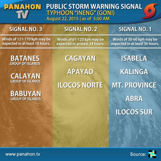
Storm signals are still up over some areas of Northern Luzon.

Stormy weather will prevail in Batanes, Ilocos Norte, Apayao and Cagayan, including Calayan and Babuyan Group of Islands. The provinces of Isabela, Kalinga, Mountain Province, Abra and Ilocos Sur will experience rains with gusty winds.
As Ineng prevails, the enhanced habagat will continue to dump monsoon rains over Metro Manila, Benguet, La Union, Pangasinan, Zambales and Bataan. Occasional rains are expected over the rest of Luzon, and Western and Central Visayas. Mindanao will have partly cloudy to cloudy skies with isolated thunderstorms.
Meanwhile, strong to gale force winds associated with habagat will cause rough to very rough sea conditions in the seaboards of Luzon and the eastern seaboard of Visayas. Wave height ranging from 3.4 to 4.5 meters and winds of 52 to 63 kilometers per hour are expected over the said areas.
Over the past few days, PAGASA has recorded high rainfall in some areas in Northern Luzon. These rains were brought by the combined effect of the typhoon and enhanced habagat.

Latest Advisories
