As of 3:00 a.m., a Low Pressure Area (LPA) was last spotted 1,030 kilometers east of Aparri, Cagayan. According to PAGASA Weather Forecaster Meno Mendoza, the LPA is expected to dissipate in the following days, so we can expect a storm-free weather in the next 3 to 5 days.
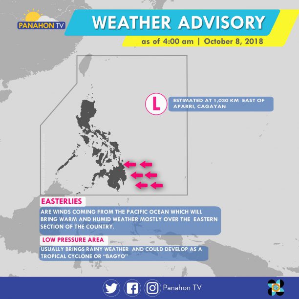
Meanwhile, Easterlies or eastern winds coming form the Pacific Ocean are affecting the eastern section of Mindanao. Partly cloudy to cloudy skies with isolated rain showers will prevail in Metro Manila and the rest of the country.
No gale warning is issued today.
The Intertropical Covergence Zone (ITCZ), which is an imaginary line where the Northern and Southern air meet, brings cloudy skies with scattered rain showers and thunderstorms in Metro Manila, Central Luzon, CALABARZON, MIMAROPA, Western and Central Visayas and Mindanao. The rest of the country will experience partly cloudy to cloudy skies with isolated rain showers caused by localized thunderstorms.
According to PAGASA Weather Forecaster Gener Quitlong, two weather disturbances are being monitored. First is the LPA outside the Philippine Area of Responsibility (PAR) located 2,345 kilometers (km) west of Mindanao. It has no direct effect yet on the country, but is expected to enter PAR by Friday or Saturday, causing scattered rains in the country. The second weather disturbance, a shallow Low Pressure Area, is near Palawan, but is expected to dissipate in the following days.
No gale warning is issued today.
Rains, induced by three weather systems, will make flash floods and landslides possible in some parts of the country.
At 3:00 a.m., the Low Pressure Area (LPA) was estimated at 265 kilometers southwest of Puerto Princesa City, Palawan. As the Tail-end of a Cold Front dampens the eastern sections of Southern Luzon and Visayas, the Northeast Monsoon brings rains in portions of Northern Luzon.
In the next hours, Bicol Region, Quezon, Palawan, Eastern Visayas and Zamboanga Peninsula will experience cloudy skies with scattered rain showers and thunderstorms that may trigger flash floods or landslides. In Cagayan Valley, Cordillera and Ilocos Region, partly cloudy to cloudy skies will prevail with isolated light rains. In the rest of the country, including Metro Manila, partly cloudy to cloudy skies or generally fair weather can be enjoyed with possible isolated rain showers.
Gale warning is still hoisted in the northern seaboards of Northern Luzon that covers Batanes, Babuyan Group of Islands, the northern coasts of Cagayan and Ilocos Norte. In these areas, fishing boats and small seacraft are prohibited from venturing due to rough to very rough seas.
Portions of the country will experience rains due to a Low Pressure Area (LPA) within the Philippine Area of Responsibility (PAR).
At 3:00 a.m., this weather disturbance was spotted at 615 kilometers east-southeast of Hinatuan, Surigao del Sur. According to PAGASA Weather Forecaster Chris Perez, the LPA has a slim chance of developing into a Tropical Cyclone. However, Caraga and Davao will still endure cloudy skies with scattered to widespread rain showers and thunderstorms that may trigger flash floods or landslides. Eastern and Central Visayas, and the rest of Mindanao will likewise experience cloudy skies with scattered rain showers and thunderstorms.

Amihan, the cold and dry air from Siberia is also affecting Northern Luzon. This will bring light rains iin the regions of Cagayan, Cordillera, and Ilocos. The rest of Luzon, including Metro Manila, and Western Visayas can enjoy generally fair weather though localized thunderstorms are still possible.
In Luzon, temperatures are also expected to soar. In Metro Manila, a scorching 33 degrees Celsius air temperature is anticipated today.
A new weather disturbance was spotted outside the Philippine Area of Responsibility (PAR).
According to PAGASA Weather Forecaster Meno Mendoza, though the Low Pressure Area (LPA), located east of Visayas, has a slim chance of developing into a Tropical Cyclone, it will still induce rains.
Due to the trough or extension of the LPA, Bicol Region and Eastern Visayas will have cloudy skies with scattered rain showers and thunderstorms that can trigger flash floods or landslides. With the presence of the Northeast Monsoon, cloudy skies with scattered rains will be experienced in Cagayan Valley Region, Cordillera Administrative Region and the provinces of Aurora and Quezon. In the rest of Luzon, including Metro Manila, generally fair weather will prevail except for chances of isolated rains. The remaining parts of the country can also enjoy fair weather conditions but with chances of localized thunderstorms.
Gale warning is still in effect in the northern seaboards of Northern Luzon, the western seaboards of Central and Southern Luzon, and the eastern seaboard of Central and Southern Luzon. These include coasts of Batanes, Calayan, Babuyan, Cagayan, Ilocos Norte, Ilocos Sur, La Union, Pangasinan and Isabela, Zambales, Bataan, Palawan, Aurora, Camarines Provinces, Catanduanes, and the eastern coast of Quezon including Polillo Island. Fishing boats and other small seacraft are prohibited from venturing while larger sea vessels are alerted against rough to very rough seas.
The Low Pressure Area (LPA) east of Mindanao has dissipated, leaving two weather systems dominant.
Today, Cagayan Valley, Cordillera, Aurora and Quezon will experience cloudy skies with scattered rains. In Visayas, Bicol Region, Caraga, Northern Mindanao and Zamboanga Peninsula, cloudy skies with scattered rains showers and thunderstorms will prevail, making floods or landslides possible. In Metro Manila, Ilocos Region and Central Luzon, partly cloudy to cloudy skies with isolated rains will be experienced. In rest of the country, partly cloudy to cloudy skies will be experienced only with isolated rain showers.
With the surge of Amihan, gale warning is hoisted off the seaboards of Northern Luzon, down to the western and eastern seaboards of Central and Southern Luzon. These include Batanes, Calayan, Babuyan, Cagayan, Ilocos Norte, Ilocos Sur, La Union, Pangasinan, Isabela, Zambales, Bataan, Palawan, Aurora, Camarines Provinces, Catanduanes and the eastern coast of Quezon including Polillo Island. Due to rough to very rough sea condition, fishing boats and small sea craft are prohibited from venturing, while larger vessels are alerted against big waves.
A new weather disturbance has developed within the Philippine Area of Responsibility (PAR). At 3:00AM today, the Low Pressure Area (LPA) was at 505 km east of Hinatuan, Surigao del Sur. According to PAGASA Weather Specialist Chris Perez, it has slim chance of developing into a tropical depression. Meanwhile, the Northeast Monsoon is affecting Northern and Central Luzon.
Today, Cagayan Valley Region, Cordillera Administrative Region and the province of Aurora will have cloudy skies with scattered rains. In Metro Manila, Ilocos Region and the rest of Central Luzon, partly cloudy to cloudy skies will prevail except for isolated rains. In Mindanao and Eastern Visayas, cloudy skies with scattered rain showers and thunderstorms will be experienced. Partly cloudy to cloudy skies with isolated rain showers will dominate.
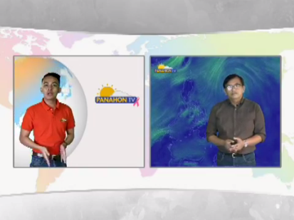
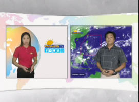
Here’s the replay of today’s interview:
A new weather disturbance has developed within the Philippine Area of Responsibility (PAR).
At 11:00 AM today, the Low Pressure Area (LPA) was at 300 kilometers east-southeast of Hinatuan, Surigao del Sur. PAGASA Weather Forecaster Shelly Ignacio said, the LPA has a slim chance of developing into a tropical cyclone but will still dampen parts of Visayas and Mindanao.
The trough of the LPA will bring moderate to heavy rains over Palawan, the whole of Visayas, and CARAGA while light to moderate rains will prevail over Northern Mindanao. The Tail-end of a Cold Front will bring light to moderate rains over the provinces of Albay, Sorsogon, Masbate, and Romblon. Residents in these areas must undertake precautionary measures against possible flash floods and landslides and coordinate with their respective local disaster risk reduction and management offices.
Meanwhile, Northeast Monsoon is bringing rains to Northern and Central Luzon, and Tail-End of a Cold Front incudes rains in the eastern section of Southern Luzon. Today, Bicol Region, MIMAROPA, Visayas, Mindanao will have cloudy skies with scattered rain showers and thunderstorms, making flash floods and landslides possible. In Cordillera, Cagayan Valley, Aurora and Quezon, cloudy skies with scattered rains will be experienced. The rest of Luzon, including Metro Manila, will have partly cloudy to cloudy skies, or generally fair weather with isolated rains.
With the surge of Amihan, gale warning remains in the northern and eastern seaboards of Northern Luzon, down to the eastern seaboards of Central Luzon, South, rn Luzon and Visayas. Affected provinces include Batanes; Babuyan Group of Islands; the northern coast of Ilocos Norte; Cagayan; Isabela; Aurora; the eastern coast of Quezon including Polillo Islands; the northern and eastern coasts of Camarines provinces; Catanduanes; the eastern coasts of Albay and Sorsogon; Northern Samar and Eastern Samar. In these areas, fishing boats and small seacraft are prohibited from venturing due to rough to very rough seas.


The Low Pressure Area (LPA) southeast of Puerto Princesa City, Palawan has developed into a Tropical Depression and was given the local name #TinoPH.

At 10:00 AM today, the Tropical Depression was located at 245 kilometers east-southeast of Puerto Princesa City, Palawan. It has maximum winds of 55 kilometers per hour (kph) with gustiness of 80 kph, moving in a west-northwest direction at a speed of 28 kph. It is expected to exit the Philippine Area of Responsibility tomorrow morning.

This weather disturbance is expected to make landfall in Southern Palawan this afternoon, between 4:00 PM to 6:00 PM. Tropical Cyclone Warning Signal Number 1 was hoisted in the said province.

Meanwhile, residents of MIMAROPA (Mindoro, Marinduque, Romblon and Palawan), the Bicol Region, Eastern Visayas, Caraga and Panay Island are alerted against possible flash floods and landslides. Metro Manila, CALABARZON (Cavite, Laguna, Batangas, Rizal and Quezon), and the province of Aurora will experience cloudy skies with light to moderate rains and isolated thunderstorms.
Sea travel is risky in the seaboards of Palawan due to moderate to rough seas brought by Tropical Depression #TinoPH.