The El Niño phenomenon indicates the unusual warming of the Pacific Ocean, which happens every two to seven years, typically in the final quarter of the year. And although this happens in the ocean, its effect is massive, taking its toll on economies at local and global scales.
Last February, PAGASA warned the public about the weak El Niño that will prevail until May, bringing droughts in many parts of Luzon and Mindanao. In spite of the reduced rainfall in the country, can storms still prevail?
A resounding TRUE.
The Philippines is situated in the Western North Pacific where an average of 20 cyclones cross our area of responsibility every year. Climatological observations of PAGASA show that some of these extreme weather events have happened during El Niño.
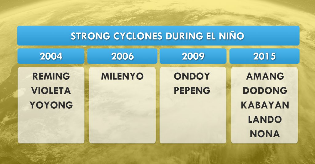
A List of Strong and Devastating Cyclones during the El Niño Phenomenon in Recent Years
These local names, except for Yoyong, Amang, Dodong and Kabayan, were removed from the list of cyclones to prevent psychological relapse among survivors. Ondoy is just an example of a disastrous storm in the presence of a strong El Niño phenomenon.
The El Niño phenomenon is part of the natural climate variability. This will be felt in provinces away from the ocean such as the Climate Type III area, which is relatively dry from December to February or from March to May. Currently, the connection between global warming and the increased frequency of El Niño trends is still inconclusive.
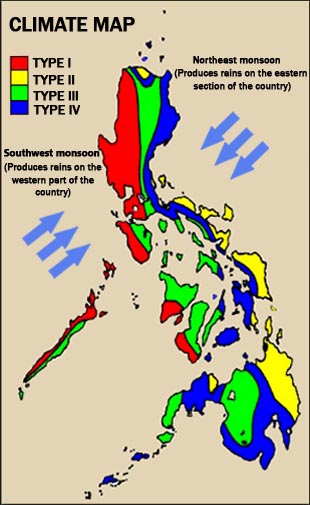
Climate Map Based on Rainfall
Climate Type III is mostly enclosed by land. Hence, these regions rely on rains for water supply.

Average Number of Cyclones that will enter the Philippine Area of Responsibility
According to PAGASA, tracks of cyclones are forecast to become stronger with erratic northward tracks.
We’ve just entered the last month of summer vacation! For some, this is the perfect time to indulge in their “huling hirit sa tag-init” fashion, selfies, playlist and memories. So, wherever you plan to spend the rest of your vacation, make sure to enjoy every moment with your family and friends.
In the midst of the Hot and Dry Season, several areas are recently experiencing rains. Weather-wise, you probably have few questions in mind. Fret not; we’ve already prepared the answers!
Are we expecting a “bagyo” this month?
According to PAGASA, different weather systems normally affect the country during this month. These include the Easterlies, Ridge of High Pressure Area (HPA), Tail End of a Cold Front, Intertropical Convergence Zone, Low Pressure Area (LPA) and Tropical Cyclone.
Despite the ongoing tag-init, the weather bureau is not dismissing the possibility of a tropical cyclone to enter or develop within the Philippine Area of Responsibility (PAR) this May. An average of 0 to 1 tropical cyclone is expected with its two possible scenarios: 1) a chance of hitting the landmass or 2) re-curving away from the country, depending on the effect of the HPA.
According to PAGASA Weather Forecaster Robert Badrina, historical records in the past 70 years show that tropical cyclones which entered the PAR during May were under Typhoon category. Hence, stronger typhoons usually cross our boundary during this month. The most recent one, Typhoon “Dodong”, entered the PAR on the second week of May last year.

How long will tag-init last?
Hot days are not over yet! PAGASA says tag-init normally lasts until the end of May. Air temperatures and heat indices will continue to soar as the Easterlies and Ridge of HPA prevail within the boundary.
Easterlies are warm and humid winds coming from the Pacific Ocean. This weather system is the main reason why we feel the sweltering heat.
In fact, the highest temperatures in Philippine history were recorded during the month of May.

After a scorching day, why do we experience thunderstorms?
May is considered as “thunderstorm month” because this is the time of the year wherein thunderstorms develop more frequently. As temperatures rise, water cycle also speeds up and becomes more active. This triggers the formation of cumulonimbus clouds, also known as thunderstorm clouds, which bring moderate to heavy rains, gusty winds, along with thunder and lightning.
Expect more thunderstorms in the coming days as we approach the transition period before the rainy season.

How’s El Niño?
PAGASA explains that the El Niño is already in its decaying stage. It will continue to weaken further this May until July, where it is expected to return to its neutral condition.
Though some areas will receive an improved amount of rainfall, several areas should still prepare for the last wave of El Niño. Dry conditions, dry spells and droughts could still affect the country in the next few weeks.


Rising temperatures, sweltering heat, and that sticky feeling – there’s no doubt that we’re already experiencing tag-init! To help you understand those weather reports better, here are some of the meteorological terms that you will often encounter this season:
1. DRY SEASON
Technically, we do not have “summer”. The Philippines, being a tropical country, has only two official seasons – wet and dry. Summer is experienced in temperate regions with four seasons. In our country, Dry season or tag-init is the equivalent of summer.
2. EASTERLIES
These are warm and humid winds coming from the Pacific Ocean, which usually affect the eastern section of the country. However, since warm air or heat is a major factor for cloud formation, Easterlies can also generate isolated thunderstorms, mostly in the afternoon or evening.
3. RIDGE OF HPA
“Ridge” refers to the extended part of a High Pressure Area or an anticyclone. Unlike a Low Pressure Area, this indicates an area where the atmospheric pressure is higher than its surroundings.
Formation of clouds is usually suppressed, thus, less chance of rains. Fair weather is typically experienced when a Ridge of High Pressure Area extends over the archipelago.
4. GENERALLY FAIR WEATHER
Many people still get confused when they hear this. Generally fair weather means partly cloudy to cloudy skies with chances of isolated rain showers or thunderstorms. Less than half of the day will be cloudy, but rains are still possible, depending on the prevailing weather system.
On the other hand, “isolated” means localized. This means that it may be raining in your place, but not in the nearby areas. It happens when clouds are scattered in different parts of the atmosphere.
5. AIR TEMPERATURE
Air temperature is determined by using a weather instrument, commonly a thermometer. Also termed as “surface temperature”, it is obtained when a thermometer is exposed to the air but is sheltered from direct sun exposure.
6. HUMIDITY
Humidity is the amount of water vapor or moisture in the air. It can make high temperatures even more unbearable, often with a moist or “malagkit” feeling. Humidity is an important factor that affects the weather and climate as well.
7. HEAT INDEX
Also called as “human discomfort index”, heat index refers to the temperature obtained from the high air temperature and relative humidity. It also describes how the human body perceives the heat or the warm weather.
PAGASA says full exposure to sunlight may increase the heat index by 9 degrees Celsius. PAGASA Weather Forecaster Aldczar Aurelio says the heat index is always higher than the actual air temperature. High heat indices could lead to fatigue, heat cramps, heat exhaustion or heat stroke.
8. THUNDERSTORM
Despite the fact that we are already in Tag-init Season, we may still experience rains brought by thunderstorms. Most people get confused when a downpour occurs after hours of scorching heat.
According to Former US Vice President Al Gore, also the founder of the Climate Reality Project, warmer air holds more moisture. Heat also speeds up the evaporation, bringing more clouds, which could later dump moderate to heavy rains.
During a thunderstorm, lightning and thunder also occur, along with gusty winds. Thunderstorms usually occur in the afternoon or evening, which can last for 1 to 2 hours.
9. EL NIÑO
El Niño is a climatic condition wherein an unusual increase in sea surface temperature (SST) or warming of the ocean is observed. In the Philippines, it mostly affects the agricultural sector due to reduced rainfall and warmer weather.
PAGASA says the prevailing El Niño may also have an effect on the current Hot and Dry season. Temperatures may continue to rise, and the duration of tag-init may be prolonged as well.
10. TROPICAL CYCLONE
Tropical cyclone is the general term for a “bagyo,” which starts out from a cloud cluster that develops into a Low Pressure Area (LPA), which has an atmospheric pressure lower than its surrounding locations.
One common misconception during tag-init is that it’s not normal to have a Tropical Cyclone. Every month, there is a chance for a Tropical Cyclone to enter or develop within the Philippine Area of Responsibility (PAR).
In fact, we monitored “Bagyong Chedeng” just last year and it coincided with the observance of the Holy Week. Chedeng intensified as a Typhoon and even made landfall in Isabela.
This April, the average number of tropical cyclone is 0 or 1. When it comes to the track, it may make landfall or may re-curve northward away from the landmass.
Related articles:
WEATHER-WISER: 10 Must-Know Weather Words | Panahon TV Blog
Climate Clever: 10 Climate Change Terms You Need to Know Now | Panahon TV Blog
All About Thunderstorm | Panahon TV Blog
Why Heavy Rains = Heavy Traffic | Panahon TV Blog
Sources:
PAGASA-DOST
NOAA
www.mymobilebay.com
www.study.com
PAGASA’s climate outlook shows that most parts of the Philippines will probably experience a Meteorological Drought, which, according to the National Centers for Environmental Information, occurs when dry weather patterns dominate an area. Meanwhile, Agricultural Droughts happen when crops are affected.
Because of the ongoing El Niño, the forecast rainfall for February is below-normal or between 41 to 80 percent. Based on the map below, a large part of Luzon, Visayas and Mindanao will experience less rainfall. These include the Cordillera Administrative Region (CAR), except for Apayao where near-normal rainfall is expected.
In Region I, Ilocos Norte, Ilocos Sur and La Union will receive above-normal rainfall. However, Pangasinan will experience a different scenario with only a 22.9 percent amount precipitation in February, which means drought is more probable in this area.
The good news: most provinces in Region II, Central Luzon, National Capital Region, Region IV-A, MIMAROPA and Bicol Region will also receive below to above-normal rainfall, thanks to the Amihan or the Northeast Monsoon and occasional Tail End of a Cold Front, bringing light to moderate rains.
In Region VI, Negros Island Region, Region VII, Region VIII, Davao Region, SOCCSKSARGEN, CARAGA and ARMM, below-normal rainfall is expected, quantified between 41 to 80 percent. The Zamboanga Peninsula and Northern Mindanao are most likely to experience the effect of El Niño this month because of way-below normal rainfall or below 40 percent amount of rains. Most of these areas consist of agricultural farms, thus making it more prone to Agricultural Drought.
According to PAGASA, A Dry Spell is characterized by three consecutive months of below- normal rainfall conditions, while Droughts are defined as having three consecutive months of way below-normal rainfall conditions. In the latest climate outlook of the weather bureau, 26 provinces (31% percent of the country) are likely to experience droughts.

Lanao Del Norte in Region X reported that there are 1,216 hectares of corn, 976 hectares of high-value crops and 694 hectares of rice affected by the Dry Condition. Meanwhile, 22 municipalities of Bukidnon are also suffering from the effect of El Niño, with 31,750 hectares of corn, 1,705 hectares of cassava and 4.0,317 hectares of rice affected by the Dry Season. Maguindanao in ARMM is now placed under a State of Calamity, where more than 20,000 farmers and 17,000 hectares of rice and corn are affected.
The Department of Agriculture (DA) is focusing on providing mitigation programs especially to areas severely affected by the El Niño. Cloud seeding, the process of scattering silver iodide aerosols or dry ice into clouds containing supercooled water to induce rain, is done to abate water scarcity.
The DA is also awaiting the release of a P900 million budget to fast-track the agency’s interventions.
With the unfavorable effects of El Niño, farmers are assured that they can rely on DA. The agency is accepting concerns and inquiries through its DA El Niño Hotline and PhilRice Text Center.

The El Niño phenomenon has become one of the most pressing global concerns today. Just recently, PAGASA has issued an update and climate outlook to prepare the public for the impending effects of El Niño, which is now being classified as a “strong” one. El Niño is a climatic condition wherein an unusual increase in sea surface temperature (SST) or warming of the ocean is observed.
The World Meteorological Organization (WMO) says a mature and strong El Niño is now in progress in the tropical Pacific, and will more likely to strengthen before the end of the present year.
WMO added that the 2015-2016 El Niño event will potentially be among the four strongest since 1950. These include the El Niño phenomena experienced during 1972-73, 1982-83 and 1997-98.
Meanwhile, according to the International Research Institute (IRI), the chance of El Niño lasting throughout the March-April-May 2016 season is greater than 95%. It also has a near 78% chance of continuing throughout the April-May-June 2016 season.

PAGASA says that from October this year until March of 2016, the weather systems that may affect the country are the Northeast Monsoon, Tail end of a cold front, Easterly Wave, Intertropical Convergence Zone (ITCZ), Low Pressure Areas (LPAs), Ridge of High Pressure Area and Tropical Cyclones.
When it comes to rainfall, the forecast of the weather bureau shows significant reduction in the coming months. This October, some areas of Mindanao are expected to receive the highest amount, while most parts of the archipelago may possibly have less rainfall.


20% of our country will experience dry conditions, dry spells and droughts. A dry condition is defined as two consecutive months of below-normal rainfall condition. A dry spell, on the other hand, happens when below-the-normal rainfall is experienced in three consecutive months, while a drought is defined as three consecutive months of way-below normal rainfall.
Currently, 23 provinces are under dry conditions, 10 under dry spells, and 6 are threatened by droughts.

According to PAGASA, four to eight tropical cylones may develop or enter the Philippine Area of Responsibility (PAR) until June 2016. Two to five tropical cyclones are expected to enter the PAR until the end of December 2015.
The public is reminded to keep monitoring updates, and to practice water conservation for preparation against the impacts of the prevailing El Niño.
Sources:
WMO
IRI
PAGASA-DOST