As of 3:00 a.m., Typhoon Kong-Rey was last spotted 1,565 kilometers (km) east of Southern Luzon. It has maximum sustained winds of up to 130 kilometers per hour (kph) and gustiness of up to 160 kph, moving west-northwest at 15 kph. Due to the trough of the Typhoon, cloudy skies with scattered rain showers and thunderstorms are expected in Bicol Region and Eastern Visayas. Meanwhile, partly cloudy to cloudy skies with isolated rain showers will prevail in Metro Manila and the rest of the country.
According to PAGASA Weather Forecaster Ariel Rojas, the Typhoon Kong-Rey will enter the Philippine Area of Responsibility (PAR), making it the 17th Tropical Cyclone to enter PAR this year.
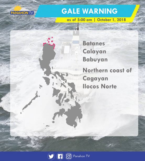
Gale warning is issued in the following areas:
Despite the weather disturbance spotted outside the Philippine Area of Responsibility (PAR), Metro Manila and the rest of the country will experience fair weather conditions associated with isolated rain showers. Meanwhile, Typhoon #PaengPH is still slowly moving away, and was last spotted at 680 kilometers (km) northeast of Basco, Batanes. According to PAGASA Weather Forecaster Gener Quitlong, #PaengPH is expected to exit PAR today at around 6:00 to 8:00 a.m.
Update on Tropical Depression: It was last spotted at 2,245 km east of Visayas, and is expected to enter PAR on Tuesday (October 2). Forecast shows that once the Tropical Depression enters PAR, it will develop into a Tropical Storm and will be named “Queenie.”
A Low Pressure Area (LPA) outside the Philippine Area of Responsibility (PAR) was spotted at 2,915 kilometers East of Mindanao. According to PAGASA Weather Forecaster Meno Mendoza, the LPA may develop into a Tropical Depression and is expected to enter PAR on Tuesday (October 2).
At 3:00 a.m. today, the eye of Typhoon #PaengPH was spotted at 695 kilometers east-northeast of Basco, Batanes with maximum sustained winds of 160 kilometers per hour (kph) near the center and gustiness of up to 195 kph. It is moving northwest slowly and is expected to exit the Philippine Area of Responsibility (PAR) tomorrow morning (September 29).
Today, Metro Manila and the rest of the country will experience partly cloudy to cloudy skies with isolated rain showers due to localized thunderstorms.
With its northward movement, Typhoon Paeng is forecast to leave the Philippine Area of Responsibility (PAR) on Saturday without any landfall activity.
Enhanced by the Typhoon, the Southwest Monsoon will bring cloudy skies with scattered rain showers in Zamboanga Peninsula, Northern Mindanao and Caraga. Elsewhere, partly cloudy to cloudy skies prevail and localized thunderstorms are possible. PAGASA raised a gale warning off the northern seaboards of Northern Luzon and the eastern seaboards of Luzon and Visayas. Fisherfolk and those with small seacraft are advised not to venture out, while larger vessels are advised to take precautionary measures against rough to very rough sea conditions.
Meanwhile, a new weather disturbance may threaten the country next week. According to PAGASA Weather Forecaster Ariel Rojas, a Low Pressure Area (LPA) was spotted at 3,100 kilometers east-southeast of Mindanao, outside PAR. It is forecast to intensify into a tropical cyclone and enter PAR next week.
As of 3:00 a.m., Typhoon Paeng was last spotted 725 kilometers east of Basco, Batanes. It has maximum sustained winds of up to 170 kilometers per hour (kph) and gustiness of up to 210 kph as it continues to move northward. Meanwhile, Metro Manila and the rest of the country will experience partly cloudy to cloudy skies with isolated rain showers caused by localized thunderstorms.
According to PAGASA Weather Forecaster Ariel Rojas, the typhoon has slightly weakened and is expected to exit the Philippine Area of Responsibility by Saturday.
Due to the threat of Typhoon Paeng in the coastal areas of Northern Luzon and Eastern Seaboards of Luzon and Visayas, gale warning was issued in the following areas:

Northern Luzon should brace for rains induced by Typhoon Paeng.
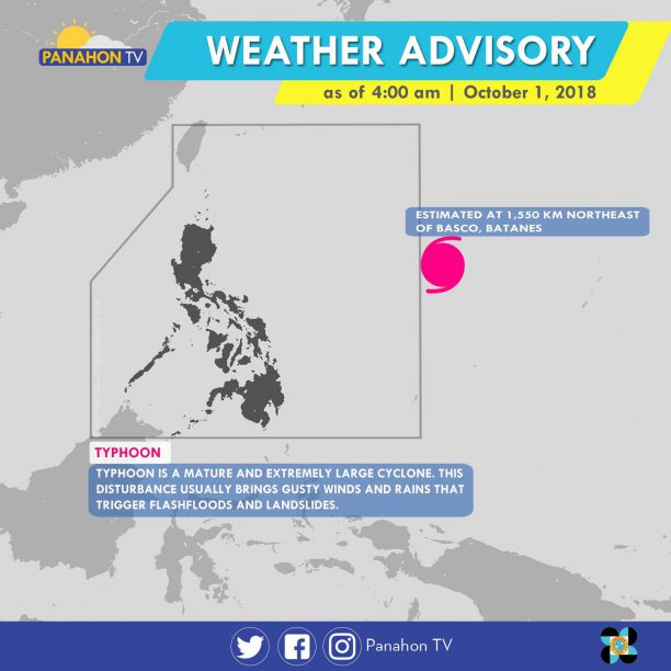
At 3:00 a.m., the eye of the typhoon was spotted 740 kilometers east of Basco, Batanes. It has slightly intensified with maximum sustained winds of 200 kilometers per hour (kph), gustiness of up to 240 kph, moving west-northwest at 10 kph. According to PAGASA Weather Forecaster Ariel Rojas, light to moderate rains will prevail in Northern Luzon starting Friday. Tropical Cyclone Warning Signals may also be hoisted. The typhoon is expected to exit the Philippine Area of Responsibility on Saturday.
Today, the trough or extension of the typhoon will bring cloudy skies with scattered rain showers in Western Visayas, Zamboanga Peninsula, ARMM and Soccsksargen. Elsewhere, partly cloudy to cloudy skies prevail, but isolated rain showers are still possible due to localized thunderstorms.
PAGASA raised a gale warning off the northern seaboards of Northern Luzon and eastern seaboards of Luzon. Fisherfolk and those with small seacraft are advised not to venture out, while larger vessels are advised to take precautionary measures against rough to very rough sea conditions.
The tropical cyclone with international name “Trami” has entered the Philippine Area of Responsibility (PAR) and is now called through its local name, Paeng.
Now categorized as a Typhoon, Paeng was last spotted at 1,100 kilometers east of Tuguegarao City, Cagayan. It has maximum sustained winds of 170 kilometers per hour (kph) near the center and gustiness of up to 210 kph, moving at 20 kph. Although landfall is less likely to happen, the typhoon is expected to move west-northwest towards the Batanes-Babuyan Group of Island where Tropical Cyclone Warning Signals may be hoisted between Thursday and Friday.
Due to its proximity, the typhoon no direct effect on any part of the country yet. Today, partly cloudy to cloudy skies will prevail in the entire country but isolated rain showers are still possible.
As of 3:00 a.m. today, a Tropical Depression was spotted at 2,015 kilometers east of Southern Luzon. According to PAGASA Weather Forecaster Loriedin Dela Cruz, though the Tropical Depression is not expected to make landfall, it may enter the Philippine Area of Responsibility (PAR) tomorrow afternoon (September 23). Once it becomes a Tropical Storm, it will be called by its local name, “Paeng”.
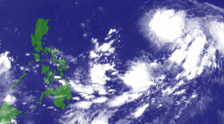
Meanwhile, the Intertropical Convergence Zone (ITCZ) continues to affect Southern Luzon, Visayas and Mindanao. This weather system brings cloudy skies with scattered rain showers and thunderstorms in MIMAROPA, Visayas, Zamboanga Peninsula, Northern Mindanao and CARAGA.
Partly cloudy to cloudy skies with isolated rain showers will be experienced in Metro Manila and the rest of the country.
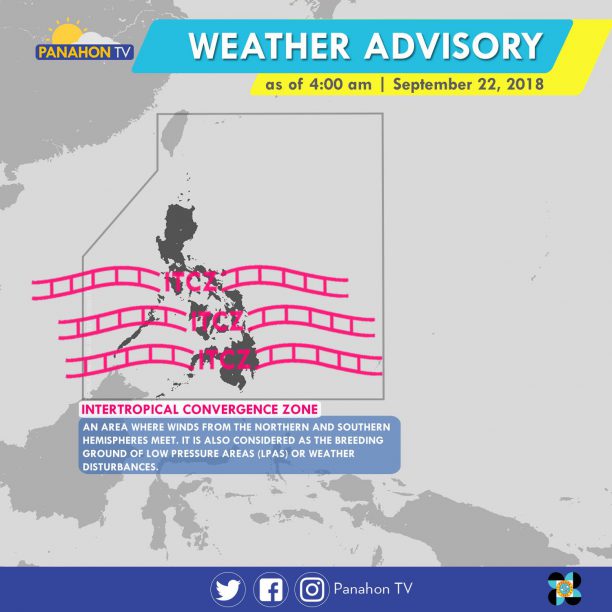
The Intertropical Covergence Zone (ITCZ), which is an imaginary line where the Northern and Southern air meet, brings cloudy skies with scattered rain showers and thunderstorms in Metro Manila, Central Luzon, CALABARZON, MIMAROPA, Western and Central Visayas and Mindanao. The rest of the country will experience partly cloudy to cloudy skies with isolated rain showers caused by localized thunderstorms.
According to PAGASA Weather Forecaster Gener Quitlong, two weather disturbances are being monitored. First is the LPA outside the Philippine Area of Responsibility (PAR) located 2,345 kilometers (km) west of Mindanao. It has no direct effect yet on the country, but is expected to enter PAR by Friday or Saturday, causing scattered rains in the country. The second weather disturbance, a shallow Low Pressure Area, is near Palawan, but is expected to dissipate in the following days.
No gale warning is issued today.